
Syed Shayan Real Estate Archive
Syed Shayan Real Estate Archive
From Real Estate History
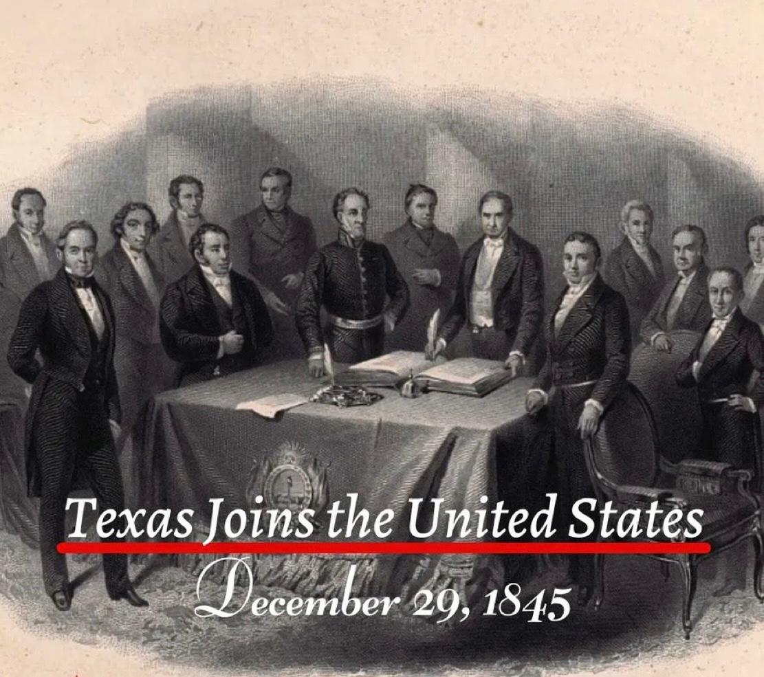
On 29 December 1845, Texas formally became the twenty eighth state of the United States. This event was not merely a political decision. It marked an extraordinary turning point in the global history of land ownership and real estate. As a result of this single day’s decision, approximately 259000 square miles, or nearly 695000 square kilometres, came under the jurisdiction of the American federal system.
Texas held a unique position because it had previously existed as an independent republic. The land was already settled. Agriculture was actively practised. Claims of private as well as communal ownership were firmly in place.
When Texas was annexed by the United States, all these lands were brought under the American constitutional and legal framework in a single moment. This transition reshaped land registration, land claims, agricultural ownership, and future urban planning within an entirely new framework influenced by American legal culture. Concepts of ownership, legal documentation, boundary demarcation, and patterns of urban expansion shifted from local traditions to align with the federal American system.
The historical importance of this annexation is further underscored by the fact that it represented the largest territorial addition ever gained through the admission of a sovereign state into the United States. At the time, the area exceeded that of several European countries and opened the path for the expansion of the American property market towards the southern and western regions. In subsequent decades, these lands formed the foundation for vast agricultural estates, railway networks, industrial centres, and newly established cities.
One of the most significant outcomes of Texas’s annexation for the United States was the acquisition of an extensive coastline, providing strong and direct access to the Gulf of Mexico.
This geographical transformation also produced a broader economic benefit for landlocked states. The development of ports along the Texas coast created new and more accessible routes for the agricultural and industrial output of inland regions to reach global markets. Over time, as expansive railway networks and integrated river systems connected these landlocked states to the Texas coastline, interior regions became part of the global trade system. In this way, the annexation of Texas emerged as a gradual yet profoundly significant milestone in the overall economic growth of the United States.
▪️Syed Shayan Real Estate Archive
▪ Reference(s):
29 دسمبر 1845 کو ٹیکساس باضابطہ طور پر امریکہ کی اٹھائیسویں ریاست بنا۔ یہ واقعہ محض ایک سیاسی فیصلہ نہیں تھا بلکہ زمینی ملکیت اور رئیل اسٹیٹ کی عالمی تاریخ کا ایک غیر معمولی موڑ ثابت ہوا۔ اس ایک دن کے فیصلے کے نتیجے میں تقریباً دو لاکھ اٹھسٹھ ہزار یعنی 259000 مربع میل، یعنی لگ بھگ چھ لاکھ پچانوے ہزار مربع کلومیٹر رقبہ امریکی حکومت کے دائرہ اختیار میں آ گیا۔
ٹیکساس کی حیثیت اس لیے منفرد تھی کہ یہ خطہ پہلے ایک آزاد جمہوریہ رہ چکا تھا۔ یہاں زمینیں پہلے سے آباد تھیں۔ زراعت ہو رہی تھی۔ نجی اور اجتماعی ملکیت کے دعوے موجود تھے۔
چنانچہ جب ٹیکساس امریکہ میں شامل ہوا تو یہ تمام زمینیں ایک ہی دن میں امریکی آئینی اور قانونی نظام کے تحت آ گئیں۔ اس عمل نے زمین کی رجسٹریشن، لینڈ کلیمز، زرعی ملکیت اور مستقبل کی شہری منصوبہ بندی کو امریکی کلچر کے زیر اثر ایک بالکل نئے فریم ورک میں منتقل کر دیا، جہاں ملکیت کے تصورات، قانونی دستاویزات، حد بندی کے اصول اور شہری توسیع کا انداز مقامی روایت کے بجائے وفاقی امریکی نظام کے مطابق ڈھلنے لگا۔
تاریخ میں اس الحاق کی اہمیت اس لیے بھی زیادہ ہے کہ یہ کسی خودمختار ریاست کے امریکہ میں شامل ہونے سے حاصل ہونے والا سب سے بڑا زمینی رقبے کا اضافہ تھا۔ یہ رقبہ اس وقت کئی یورپی ممالک سے بڑا تھا اور اسی نے امریکی پراپرٹی مارکیٹ کو جنوبی اور مغربی سمت میں پھیلنے کا راستہ دیا۔ بعد کے برسوں میں یہی زمینیں بڑے زرعی اسٹیٹس، ریلوے منصوبوں، صنعتی مراکز اور نئے شہروں کی بنیاد بنیں۔
ٹیکساس کے الحاق کا سب سے بڑا فائدہ ریاستہائے متحدہ امریکہ کو یہ بھی ہوا کہ اس کی طویل ساحلی پٹی نے امریکہ کو خلیجِ میکسیکو تک ایک مضبوط رسائی فراہم کی۔
اس جغرافیائی تبدیلی کا ایک اور فائدہ سمندر سے دور واقع لینڈ لاکڈ ریاستوں کی معاشی ترقی کی صورت میں سامنے آیا۔ ٹیکساس کی بندرگاہوں کے قیام اور ترقی سے اندرونی علاقوں کی زرعی اور صنعتی پیداوار کے لیے عالمی منڈیوں تک پہنچنے کا ایک نیا اور آسان راستہ کھل گیا۔ وقت گزرنے کے ساتھ ساتھ، جب ریلوے کے وسیع جال اور دریاؤں کے مربوط نظام نے ان لینڈ لاکڈ ریاستوں کو ٹیکساس کے ساحلوں تک رسائی دی تو یہ اندرونی علاقے بھی عالمی تجارت کے دھارے میں شامل ہو گئے۔ یوں ٹیکساس کا الحاق امریکہ کی مجموعی معاشی خوشحالی کے لیے ایک تدریجی مگر نہایت اہم سنگِ میل ثابت ہوا۔
▪️ سید شایان ریئل اسٹیٹ آرکائیو
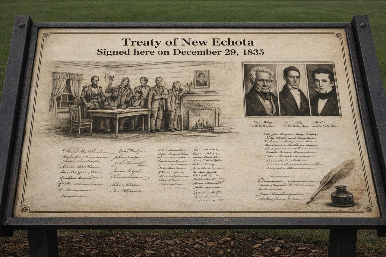
On 29 December 1835, a legal treaty was concluded in the American state of Georgia, historically known as the Treaty of New Echota. This agreement is regarded as one of the most controversial and troubling chapters in United States history, particularly in relation to land ownership, state authority, and the rights of Indigenous nations.
By the early nineteenth century, the south eastern states of the United States, especially Georgia, Alabama, and Tennessee, had become centres of an expanding agricultural economy. Cotton cultivation, commonly referred to as the Cotton Economy, was growing rapidly, leading to an exceptional demand for fertile land. Large tracts of this land were owned by Indigenous communities, most notably the Cherokee Nation. Their continued presence was increasingly viewed as an obstacle to the American policy of westward territorial expansion.
Within this context, the United States Congress passed the Indian Removal Act in 1830, which provided the legal framework for the forced relocation of Indigenous peoples from east of the Mississippi River to lands further west. The Treaty of New Echota emerged as a direct outcome of this policy.
The treaty was finalised on 29 December 1835 at New Echota, which was then the capital of the Cherokee Nation. Under its terms, the Cherokee ceded all their lands east of the Mississippi River to the United States government. This territory amounted to approximately seven million acres. In return, the government promised compensation of five million dollars and the allocation of alternative land in the west. This land lay within the area of present day Oklahoma, known at the time as Indian Territory.
From a legal perspective, the most contentious aspect of the treaty concerned the issue of representation. The agreement was not signed by the elected leadership or the national council of the Cherokee Nation. Instead, it was endorsed by a small political faction, later known as the Ridge Party, whose members included Major Ridge, John Ridge, Elias Boudinot, and Stand Watie. The principal chief of the Cherokee Nation, John Ross, along with the majority of the national council, rejected the treaty as invalid and contrary to the collective will of the people.
The United States was represented in the negotiations by John F. Schermerhorn, a federal commissioner. Despite widespread opposition among the Cherokee population, the United States Senate ratified the treaty by a margin of just one vote. This ratification elevated the agreement to the status of federal law and paved the way for the use of state force.
When a large proportion of the Cherokee people refused to comply with the treaty and abandon their ancestral lands, the United States military initiated a programme of forced removal. Between 1838 and 1839, thousands of Cherokee men, women, and children were gathered into detention camps and subsequently transported westwards. This episode became known in history as the Trail of Tears.
Historical records indicate that approximately sixteen thousand Cherokee individuals were forcibly displaced from their homelands. The journey covered an average distance of twelve hundred miles and was undertaken on foot, by riverboats, and with limited means of transport. Severe weather conditions, inadequate food supplies, disease, and poor administration resulted in the deaths of an estimated four thousand people. In the Cherokee language, this journey is remembered as Nu na da ut sun y, meaning the place where they cried.
After arriving in the west, the Cherokee Nation re established its political and social institutions in Oklahoma. Tahlequah was designated as the new capital, and systems of constitutional governance, courts, educational institutions, and newspapers were rebuilt. Nevertheless, their legal ownership of their former eastern lands was considered permanently extinguished.
The legacy of this treaty has not entirely faded in the modern era. In 2020, the United States Supreme Court, in the case of McGirt v. Oklahoma, affirmed that large parts of Oklahoma legally remain tribal reservation land, as earlier treaties had never been formally revoked. This ruling carried significant implications for land rights, jurisdiction, and property law.
[img:Images/2nd-image-29-dec.jpeg | desc:The Treaty of New Echota and the subsequent forced removal of the Cherokee people have been the subject of numerous serious documentary films and historical reconstructions based on official records and archival evidence. Notable among these are Trail of Tears: Cherokee Legacy and the PBS series We Shall Remain, which examine the legal and political consequences of the Indian Removal Act and the Treaty of New Echota. These works illustrate how treaties and federal policy were used to reshape patterns of land ownership and population geography.
]
The Treaty of New Echota has been included in the Syed Shayan Real Estate Archives to serve as a reminder of how state policy, legal instruments, and economic interests can combine to dispossess ordinary people of their land.
▪️Syed Shayan Real Estate Archive
▪ Reference(s):
29 دسمبر 1835 کو امریکہ کی ریاست جارجیا میں ایک قانونی معاہدہ طے پایا جسے تاریخ میں Treaty of New Echota کہا جاتا ہے۔ یہ معاہدہ زمین کی ملکیت، ریاست کے اختیارات اور قبائلی حقوق کے حوالے سے امریکی تاریخ کا ایک متنازع اور سیاہ باب سمجھا جاتا ہے۔
کہا جاتا ہے کہ جب امریکہ میں جنوب مشرقی ریاستیں خصوصاً جارجیا، الاباما اور ٹینیسی زرعی معیشت کا مرکز بن چکی تھیں، کپاس کی کاشت (Cotton Economy) تیزی سے پھیل رہی تھی اور زرخیز زمینوں کی مانگ میں غیر معمولی اضافہ ہو چکا تھا۔ ان علاقوں میں مقامی قبائل بالخصوص چیریکی (Cherokee) قوم کی ملکیت میں وسیع رقبہ موجود تھا، جو امریکی توسیعی پالیسی (Westward Expansion) کے راستے میں رکاوٹ سمجھا جاتا تھا۔
اس پس منظر میں 1830 میں امریکی کانگریس نے Indian Removal Act منظور کیا، جس کے تحت مقامی قبائل کو دریائے مسیسیپی کے مشرق سے مغرب کی جانب منتقل کرنے کی قانونی بنیاد فراہم کی گئی۔ نیو ایکوٹا کا معاہدہ اسی پالیسی کا عملی نتیجہ تھا۔
29 دسمبر 1835 کو یہ معاہدہ چیریکی قوم کے اس وقت کے دارالحکومت New Echota میں طے پایا۔ معاہدے کے مطابق چیریکی قوم نے مسیسیپی کے مشرق میں واقع اپنی تمام زمینیں، جن کا مجموعی رقبہ تقریباً سات ملین ایکڑ (Seven Million Acres) بنتا تھا، امریکی حکومت کے حوالے کر دیں۔ اس کے بدلے حکومت نے پانچ ملین ڈالر (Five Million Dollars) بطور معاوضہ ادا کرنے اور مغرب میں متبادل زمین فراہم کرنے کا وعدہ کیا۔ یہ رقبہ موجودہ ریاست اوکلاہوما کے علاقے میں واقع تھا، جسے اس دور میں Indian Territory کہا جاتا تھا۔
قانونی اعتبار سے اس معاہدے کا سب سے اہم اور متنازع پہلو نمائندگی (Representation) کا مسئلہ تھا۔ اس معاہدے پر چیریکی قوم کی منتخب قیادت یا قومی کونسل نے دستخط نہیں کیے۔ چیریکی فریق کی جانب سے دستخط کرنے والے افراد ایک محدود سیاسی گروہ سے تعلق رکھتے تھے، جن میں Major Ridge، John Ridge، Elias Boudinot اور Stand Watie شامل تھے۔ بعد ازاں اس گروہ کو Ridge Party کے نام سے جانا گیا۔ چیریکی قوم کے منتخب سربراہ John Ross اور اکثریتی کونسل نے اس معاہدے کو غیر قانونی (Invalid) اور قوم کی اجتماعی مرضی کے خلاف قرار دیا۔
امریکی حکومت کی نمائندگی John F. Schermerhorn نے کی، جو وفاقی کمشنر (Federal Commissioner) تھے۔ اس کے باوجود کہ چیریکی اکثریت نے معاہدہ مسترد کر دیا تھا، امریکی سینیٹ نے اسے محض ایک ووٹ کی برتری سے منظور کر لیا۔ اس منظوری نے معاہدے کو وفاقی قانون (Federal Law) کا درجہ دے دیا اور ریاستی طاقت کے استعمال کی راہ ہموار ہو گئی۔
اس معاہدے کو نہ مانتے ہوئے چیریکی قوم کی ایک بڑی تعداد نے اپنی زمینیں چھوڑنے سے انکار کیا، جس کے نتیجے میں امریکی فوج نے جبری بے دخلی (Forced Removal) کا عمل شروع کیا۔ 1838 اور 1839 کے دوران ہزاروں چیریکی افراد کو حراستی کیمپوں میں جمع کیا گیا اور پھر مغرب کی طرف منتقل کیا گیا۔ یہ عمل تاریخ میں Trail of Tears (آنسوؤں کا راستہ) کے نام سے درج ہے۔
اعداد و شمار کے مطابق تقریباً سولہ ہزار چیریکی باشندوں کو جبری طور پر ان کی آبائی زمینوں سے دوسرے علاقوں میں منتقل کیا گیا۔ اس سفر کا فاصلہ اوسطاً بارہ سو میل (Twelve Hundred Miles) تھا، جو پیدل، کشتیوں اور محدود سواری کے ذریعے طے کیا گیا۔ سرد موسم، ناکافی خوراک، بیماریوں اور ناقص انتظامات کے باعث اندازاً چار ہزار افراد اس دوران ہلاک ہوئے۔ چیریکی زبان میں اس سفر کو Nu na da ut sun y کہا جاتا ہے، جس کا مفہوم ہے وہ راستہ جہاں رونا پڑا۔
مغرب میں پہنچنے کے بعد چیریکی قوم نے اوکلاہوما میں دوبارہ اپنی سیاسی اور سماجی ساخت قائم کی۔ انہوں نے Tahlequah کو اپنا نیا دارالحکومت بنایا، آئینی حکومت، عدالتیں، تعلیمی ادارے اور اخبارات دوبارہ منظم کیے۔ تاہم قانونی طور پر ان کی سابقہ زمینوں پر ملکیتی حقوق ختم تصور کیے گئے۔
یہ معاملہ جدید دور میں بھی مکمل طور پر ختم نہیں ہوا۔ 2020 میں امریکی سپریم کورٹ کے فیصلے McGirt v. Oklahoma نے یہ تسلیم کیا کہ اوکلاہوما کا ایک بڑا حصہ قانونی طور پر اب بھی قبائلی ریزرویشن کے زمرے میں آتا ہے کیونکہ پرانے معاہدوں کو کبھی باضابطہ طور پر منسوخ نہیں کیا گیا تھا۔ اس فیصلے نے زمین، دائرہ اختیار (Jurisdiction) اور پراپرٹی قانون پر گہرے اثرات مرتب کیے۔
نیو ایکوٹا کے معاہدے (Treaty of New Echota) اور اس کے بعد ہونے والی چیریکی قوم کی جبری منتقلی پر متعدد سنجیدہ دستاویزی فلمیں اور ڈاکیو ڈراماز موجود ہیں جو تاریخی شواہد اور سرکاری ریکارڈ کی بنیاد پر اس سانحے کو محفوظ کرتی ہیں۔ ان میں Trail of Tears: Cherokee Legacy اور PBS کی سیریز We Shall Remain نمایاں ہیں، جو Indian Removal Act اور Treaty of New Echota کے قانونی اور سیاسی اثرات کو بیان کرتی ہیں کہ کس طرح Treaties (معاہدات) اور Federal Policy (وفاقی پالیسی) کے ذریعے زمین کی ملکیت اور آبادی کی جغرافیائی ترتیب کو تبدیل کیا گیا۔
نیو ایکوٹا کا معاہدہ سید شایان رئیل اسٹیٹ آرکائیوز میں اس لیے شامل کیا گیا ہے کہ یہ جبری معاہدہ یاد دلاتا رہے کہ کس طرح ریاستی پالیسی، قانونی معاہدے اور معاشی مفادات مل کر عام انسان کی زمین کی ملکیت کو غصب کر سکتے ہیں۔
▪️ سید شایان ریئل اسٹیٹ آرکائیو

On October 20, 1978, transformative zoning legislation was enacted that specifically addressed large-scale shopping center developments, creating dedicated commercial zoning categories for retail complexes. This legal framework established standards for parking requirements, traffic management, environmental impact assessments, and community benefi...
Read More →On November 12, 1892, the British Municipal Authority of Karachi approved the Frere Town Housing Project, one of the earliest organized residential developments in the region. The project was designed to house civil servants and merchants near the port area, introducing planned streets, drainage systems, and masonry housing. It marked a turning poi...
Read More →
On October 27, 2019, Pakistan's Real Estate Regulatory Authority (RERA) became fully operational, marking a significant milestone in the country's property market regulation. The authority established comprehensive frameworks for project registration, developer accountability, and consumer protection in the real estate sector. RERA introduced manda...
Read More →
On 11 December 2018, the Supreme Court of Pakistan, under the leadership of then Chief Justice Mian Saqib Nisar, imposed a strict and highly unusual restriction on the transfer, lease, and allotment of land in Sindh. The court directed that until the provincial land revenue record was fully computerised, no allotment, lease, or transfer of governme...
Read More →
On October 23, 1892, comprehensive fire-resistant building code standards were enacted, establishing mandatory requirements for fireproof construction materials and safety features in urban buildings. These regulations emerged following devastating urban fires that had destroyed entire city blocks, prompting urgent reforms in construction practices...
Read More →
The acquisition of land for the Model Town Society was one of the most remarkable and spirited chapters in its early history. Dewan Khem Chand and his...

Between 1921 and 1924, the land for Model Town Lahore was acquired in successive phases. The process began in 1921, shortly after the establishment of...
No comments yet. Be the first to comment!