
Syed Shayan Real Estate Archive
Syed Shayan Real Estate Archive
From Real Estate History
6 Historical Event found
On 2 February 1665, British forces formally consolidated their control over the Dutch colonial settlement of New Amsterdam, located in what is now the Manhattan area of New York City. On this occasion, the settlement was renamed New York. The earliest known name of the area was Manahatta or Mannahatta, a term used by the indigenous Lenape people, generally understood to describe an island or elevated land. During the period of Dutch colonial administration, when the territory came under the authority of the Dutch West India Company, it was named New Amsterdam. Following the establishment of British control, the settlement was renamed New York in honour of the Duke of York, James, who later ascended the throne as James II. This name has remained in continuous use to the present day. The history of the settlement thus reflects a succession of political authorities, with each change in name marking a shift in sovereignty. The evolving identity of the city mirrors the broader patterns of imperial control that shaped its early development. After 1776, when the United States emerged as an independent nation, discussions did arise regarding the renaming of cities and places associated with the colonial past. By that time, however, New York had already established itself as a major commercial, legal, and urban centre. Consequently, there was neither a compelling political rationale nor any significant public demand to alter its name.
Read More >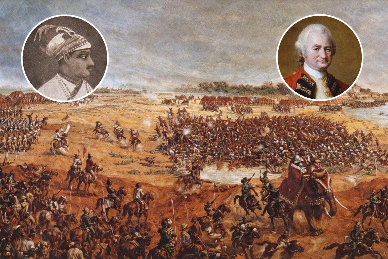
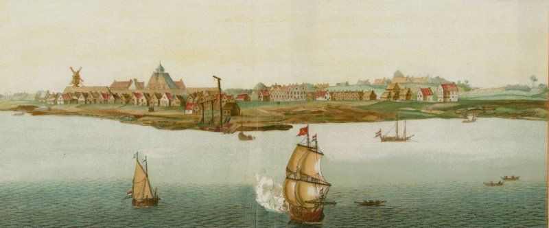
On 31 January 1757, Robert Clive signed the Treaty of Alinagar with Siraj ud Daulah, as a result of which Calcutta, known today as Kolkata, returned to British control. On the surface, this appeared to be a peace treaty. In reality, it was the agreement that paved the way for British rule in Bengal and later across the whole of India. The background to this treaty lies in the events of June 1756, when Siraj ud Daulah captured Fort William in an attempt to end British authority. In response, Robert Clive launched a military campaign in January 1757 and succeeded in retaking Calcutta. Under the Treaty of Alinagar, the East India Company was permitted to resume its commercial activities in Calcutta, strengthen its fortifications, and reclaim its previous privileges. The treaty granted the Company the following rights: • The right to mint its own coins, representing economic autonomy. • The right to fortify Calcutta, establishing military autonomy. • The right to collect land revenue directly. This marked the beginning of the dismantling of the traditional zamindari order and laid the foundation for modern title deeds. The British transformed land into a commercial commodity that could be bought, sold, and registered. Before this, land was regarded as the property of the sovereign and was allocated to subjects for use rather than ownership. Under the influence of this treaty, Calcutta, which initially consisted of only three villages, Sutanuti, Kalighat, and Govindapur, gradually developed into a Presidency Town as British power expanded. From this point onward, the British state for the first time organised land administration into a formal financial system and introduced the offices of the Collector, the revenue framework, and the principles of land registration that are now recognised as land records and the Collector Office.
Read More >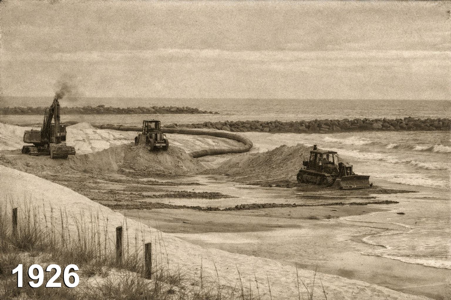
One hundred years ago, on 16 January 1926, leading English language newspapers published in Bombay, including The Times of India, Bombay Chronicle, and The Bombay, reported on an official debate held during a major government session in British India. These reports recorded that the Bombay Legislative Council had engaged in a detailed discussion on the inquiry report relating to the Back Bay Reclamation Scheme. (The term “reclamation” refers to the engineering process through which a portion of the sea is scientifically converted into new, usable land for residential, commercial, or public purposes.) The meeting took place in the Bombay Legislative Council, where members raised serious concerns about the increasing financial deficit of the scheme and the principles by which land reclaimed from the sea should be valued. Fundamental questions were formally placed on record, including whether reclaiming land from the sea was financially justified, whether such land could possess a sustainable market value, and whether public funds should be committed to the project. Several members of the Council described the scheme as an example of excessive expenditure and a potential misuse of public resources. Concerns were also expressed as to whether the land obtained through reclamation would be capable of recovering the substantial costs incurred in its development. During the proceedings, key findings from the inquiry report were presented, covering financial planning, engineering costs, and projected revenue from the future sale or utilisation of the reclaimed land. A number of members characterised the scheme as one of the most controversial and expensive urban development initiatives undertaken during the period of British India. The marine reclamation works carried out during the 1920s, while not based on modern technology, were regarded as among the most advanced engineering practices of their time. The project involved the construction of robust sea walls and stone embankments along the coastline to withstand wave action and tidal pressure. Sand and soil were dredged from the seabed and deposited through hydraulic filling, after which the land was allowed to settle naturally over several years so that excess water could drain and the soil could stabilise. Where construction was intended, deep timber and early concrete piles were driven through soft layers to reach firm strata below. Although computer modelling was not available, British engineers relied on prolonged observation of tides and coastal currents, supported by manual calculations, to design the works. As a result, despite early apprehensions, the reclaimed areas gradually stabilised and, in subsequent decades, came to be regarded among the most valuable urban real estate in the world. At the time, reclaiming land from the sea for urban and commercial use was considered a novel and unconventional idea. Many viewed it as expensive, risky, and administratively complex. However, later developments demonstrated that the scheme fundamentally transformed the city, led to exceptional increases in land values, and contributed significantly to Bombay’s emergence as a globally important centre of real estate and economic activity. [img:Images/otd-16-jan-2nd.jpeg | desc:What was once seen as an administrative burden later became the city’s greatest asset. Land reclaimed from the sea went on to shape its economic identity, carrying institutions, homes, and values that define the city today.] Although initially regarded as an administrative and financial concern, the reclaimed lands later became some of the city’s most valuable urban properties and formed the foundation of its international economic identity. Areas such as Nariman Point, Marine Drive, Cuffe Parade, Colaba, and Churchgate are all situated on land reclaimed from the sea and today accommodate major financial institutions, corporate headquarters, high rise residential buildings, and some of the most expensive urban properties in Asia.
Read More >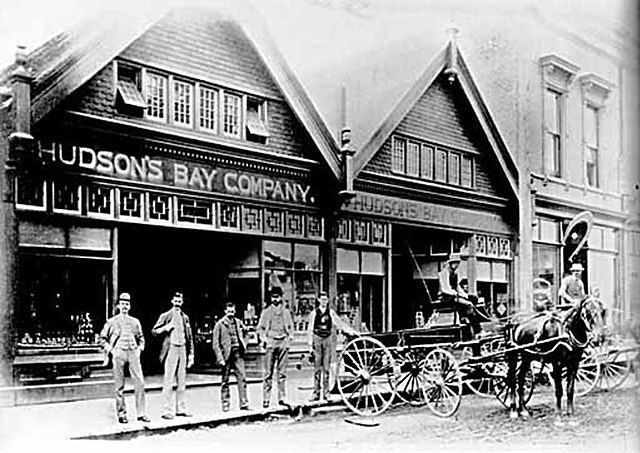
On 13 January 1849 the British government transferred the administration of Vancouver Island to the Hudson’s Bay Company, marking a distinctive moment in colonial governance. Instead of assuming direct control, the Crown delegated authority to a private commercial enterprise. The company was authorised to establish administrative order, distribute land, found settlements, regulate trade, and manage governance according to its own institutional mechanisms. In the colonial era Britain governed Canada in a manner comparable to the management of a modern gated community. Land was not owned by individuals but remained under the control of a central authority. Rules and regulations were imposed from above. Security, taxation like levies, planning, and administration operated within a structured system. Residents received protection and facilities, yet ultimate authority did not rest with them. A similar arrangement existed in colonial Canada where land was designated as Crown Land. Laws were drafted in London. Governors and senior officials were appointed from the centre. The local population benefited from order, security, and development, but decision making power remained beyond their reach. The fundamental distinction from a gated community lay in consent. Residents voluntarily choose to live within such communities, whereas colonial subjects were compelled to live under this system. This approach was not new to the British Empire. The same model had earlier been applied in the Indian subcontinent through the East India Company. What began as a trading venture gradually evolved into control over land, taxation, and governance, until effective state authority passed into the hands of a commercial organisation. The same reasoning shaped policy on Vancouver Island. Governing occupied territories through private companies was viewed as more efficient, less costly, and commercially advantageous than direct rule. As a result large scale land transfers and organised settlement began in western Canada, later known as British Columbia. The Vancouver Island experiment was, in essence, a reapplication of the colonial model previously tested in the subcontinent, employing familiar methods under a different geography. [img:Images/otd-13-jan-2nd.jpeg | desc:These images are not photographs but nineteenth century engraved illustrations. While they are not original camera captured records, they provide valuable insight into the general appearance of Vancouver Island at the time, including its trading forts, early settlements, and colonial administrative framework.] Within a few years the Hudson’s Bay Company consolidated its administrative control over Vancouver Island. It soon became evident, however, that a commercial enterprise was ill equipped to sustain long term governance. The administration of justice, maintenance of public order, and fulfilment of political responsibilities conflicted with the company’s primary objective of profit and trade. As settler numbers increased, demands for political representation, transparent legislation, and civil rights began to intensify. The situation shifted decisively after the Fraser River Gold Rush of 1858. Rapid population growth, escalating land disputes, and administrative strain led the British government to conclude that governance through a private company was no longer viable. In 1858 British Columbia was declared a Crown Colony, and in 1859 the governmental role of the Hudson’s Bay Company on Vancouver Island was formally terminated. The outcome closely resembled developments in the subcontinent, where in 1857 the East India Company proved incapable of carrying the burden of state authority, prompting direct rule by the British Crown. In 1866 Vancouver Island and British Columbia were unified, and in 1871 the territory formally entered the federal state of Canada. With this transition the era of colonial company rule came to a definitive end. In simple terms Vancouver Island today stands as a developed and autonomous region, yet its land systems, urban form, and economic orientation continue to reflect decisions taken during the British colonial period. The maps drawn, lands allocated, and towns established during that era still shape the region’s contemporary reality. A comparable pattern is evident in the subcontinent. The East India Company ceased to exist, yet the legal frameworks, bureaucratic structures, and modes of governance it introduced endured. The company departed, but its institutional legacy and imbalanced power structures remain visible in various forms even today.
Read More >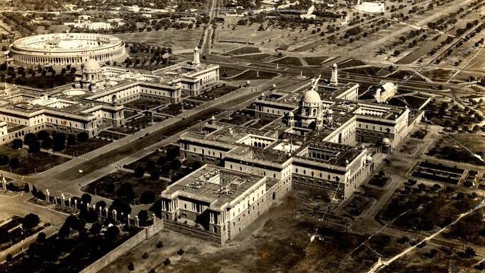
On 21 December 1911, during the period of the British Raj, a formal notice for the acquisition of land for New Delhi was published in the Punjab Gazette. This notification was issued only nine days after the proclamation of 12 December 1911, when King George V of Britain announced the transfer of the capital of British India from Calcutta to Delhi. Through this notification, the systematic acquisition of several thousand acres of agricultural land situated to the south west of present day Delhi formally commenced. These lands were subsequently developed into the core of New Delhi, upon which were constructed the Viceroy’s House now known as Rashtrapati Bhavan, the Parliament House originally called the Council House, the Central Secretariat comprising the North Block and South Block, as well as other major administrative and defence buildings that symbolised imperial authority. To connect these monumental structures, a grand ceremonial avenue later known as Rajpath was laid out, and for commemorative purposes the India Gate memorial was erected. Under the same planning framework, Connaught Place was designated as the principal commercial district of New Delhi, where banks, insurance offices and retail commercial activities were concentrated. In parallel, residential areas such as the Lutyens’ Bungalow Zone, Civil Lines and Karol Bagh emerged as planned neighbourhoods for the Viceroy, senior colonial officials, members of the civil services and the urban middle class. All these measures were undertaken under the provisions of the Land Acquisition Act of 1894, enabling the legal acquisition of land for public and governmental purposes and laying the organised urban and real estate foundation of the new imperial capital of British India. Following the announcement of the capital’s relocation, the British administration moved swiftly to advance the land acquisition process by issuing the Punjab Gazette notification of 21 December 1911, under which land values were fixed as of that date to ensure that agricultural landowners received compensation prior to the transfer of possession. As a result, lands belonging to Malcha, Raisina and other neighbouring villages were acquired, areas upon which the Parliament House, the Presidential Estate and numerous other key government buildings now stand. This historical event occupies a significant place in the history of real estate, as it marked the formal legal commencement of the largest land acquisition undertaken during the British period in the subcontinent and the construction of a new imperial capital. It not only transformed urban planning and land values but also exerted lasting influence on land use patterns and the spatial hierarchy of cities in the decades that followed.
Read More >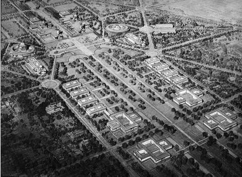
On 29 November 1912, a decisive notification was published in Part One of the Government of India Gazette, establishing the legal basis for the large scale acquisition of government land required for the construction of New Delhi, the new capital of British India. This notification followed the Delhi Durbar of 1911, during which King George V announced the transfer of the capital from Calcutta to Delhi. The British administration was therefore required to identify an appropriate site and secure the necessary land without delay for the establishment of the new city. According to the notification, and under Sections Three and Six of the Land Acquisition Act of 1894, the southern suburban districts of Delhi were declared compulsory acquisition zones. These included extensive tracts covering Raisina Hill, Malcha, the Revenue District of Mehrauli, and areas extending to the western bank of the River Yamuna. The land identified for acquisition comprised all those areas selected for the Viceroy’s House, the Central Secretariat, the Civil Lines extension, the Central Avenue, and the wider administrative framework of the proposed capital. The notification made clear that New Delhi was not intended merely as a political centre, but as a modern, comprehensively planned urban seat of government, designed to accommodate administrative institutions, major boulevards, residential settlements and commercial districts. Government records indicate that the land being acquired consisted largely of agricultural fields, woodland tracts and small rural settlements. These areas were incorporated into a consolidated urban scheme in accordance with the recommendations of the Town Planning Committee of 1912. Through this notification, the Collector of Delhi was instructed to carry out all requisite procedures without delay, including land surveys, demarcation, mapping, valuation, verification of local records and completion of acquisition proceedings, to ensure the timely construction of Lutyens Delhi. Lutyens Delhi refers to that part of New Delhi designed by the British architect Sir Edwin Lutyens. This area includes major government buildings such as the Viceroy’s House (present day Rashtrapati Bhavan), the Parliament House, the North Block, the South Block and the Central Secretariat. Its broad avenues and ordered urban layout continue to form the core of New Delhi’s administrative identity. The Gazette notification of 29 November 1912 occupies a foundational place in the history of land acquisition, urban planning, colonial architecture and state control of territory in the Indian subcontinent. These official British government records are preserved today in the National Archives of India and the India Office Records at the British Library, where the proceedings of 29 November 1912 are recognised as the formal beginning of the construction of New Delhi.
Read More >