
Syed Shayan Real Estate Archive
Syed Shayan Real Estate Archive
From Real Estate History
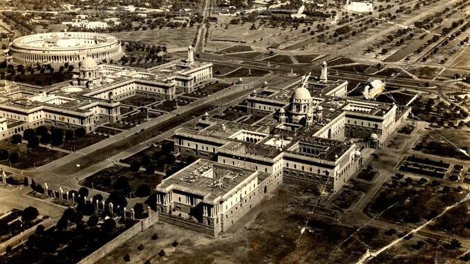
On 21 December 1911, during the period of the British Raj, a formal notice for the acquisition of land for New Delhi was published in the Punjab Gazette. This notification was issued only nine days after the proclamation of 12 December 1911, when King George V of Britain announced the transfer of the capital of British India from Calcutta to Delhi.
Through this notification, the systematic acquisition of several thousand acres of agricultural land situated to the south west of present day Delhi formally commenced. These lands were subsequently developed into the core of New Delhi, upon which were constructed the Viceroy’s House now known as Rashtrapati Bhavan, the Parliament House originally called the Council House, the Central Secretariat comprising the North Block and South Block, as well as other major administrative and defence buildings that symbolised imperial authority. To connect these monumental structures, a grand ceremonial avenue later known as Rajpath was laid out, and for commemorative purposes the India Gate memorial was erected. Under the same planning framework, Connaught Place was designated as the principal commercial district of New Delhi, where banks, insurance offices and retail commercial activities were concentrated. In parallel, residential areas such as the Lutyens’ Bungalow Zone, Civil Lines and Karol Bagh emerged as planned neighbourhoods for the Viceroy, senior colonial officials, members of the civil services and the urban middle class. All these measures were undertaken under the provisions of the Land Acquisition Act of 1894, enabling the legal acquisition of land for public and governmental purposes and laying the organised urban and real estate foundation of the new imperial capital of British India.
Following the announcement of the capital’s relocation, the British administration moved swiftly to advance the land acquisition process by issuing the Punjab Gazette notification of 21 December 1911, under which land values were fixed as of that date to ensure that agricultural landowners received compensation prior to the transfer of possession. As a result, lands belonging to Malcha, Raisina and other neighbouring villages were acquired, areas upon which the Parliament House, the Presidential Estate and numerous other key government buildings now stand.
This historical event occupies a significant place in the history of real estate, as it marked the formal legal commencement of the largest land acquisition undertaken during the British period in the subcontinent and the construction of a new imperial capital. It not only transformed urban planning and land values but also exerted lasting influence on land use patterns and the spatial hierarchy of cities in the decades that followed.
▪️Syed Shayan Real Estate Archive
▪ Reference(s):
21 دسمبر 1911 ء کو برطانوی راج کے دور میں نیو دہلی کے لئے زمین کے حصول کا باضابطہ نوٹس Punjab Gazette میں شائع کیا گیا۔ یہ نوٹیفیکیشن اس اعلان کے صرف نو دن بعد جاری ہوا تھا جس میں 12 دسمبر 1911 ء کو برطانوی راج کے بادشاہ King George V نے کلکتہ کی جگہ دہلی کو برطانوی ہندوستان کی نئی راجدھانی بنانے کا اعلان کیا تھا۔
اس نوٹیفیکیشن کے ذریعے موجودہ دہلی کے جنوب مغرب میں واقع ہزاروں ایکڑ زرعی زمینوں کے حصول کا باقاعدہ آغاز ہوا جن پر بعد ازاں Rashtrapati Bhavan جو اس وقت وائسرائے ہاؤس کہلاتا تھا، Parliament House جسے ابتدا میں کونسل ہاؤس کہا گیا، North Block اور South Block پر مشتمل مرکزی سیکریٹریٹ، اعلیٰ انتظامی و دفاعی دفاتر اور ریاستی طاقت کی علامت سرکاری عمارتیں تعمیر کی گئیں، جبکہ ان عمارتوں کو آپس میں جوڑنے کے لئے Rajpath جیسی شاہراہ اور یادگاری مقاصد کے لئے India Gate قائم کی گئی۔ اسی منصوبہ بندی کے تحت Connaught Place کو نیو دہلی کا مرکزی تجارتی علاقہ قرار دیا گیا جہاں بینک، انشورنس دفاتر اور ریٹیل کمرشل سرگرمیاں مرکوز ہوئیں، جبکہ رہائشی اعتبار سے Lutyens’ Bungalow Zone، Civil Lines اور Karol Bagh جیسے علاقے وائسرائے، اعلیٰ نوآبادیاتی افسران، سول سروس اور متوسط طبقے کے لئے منظم رہائشی بستیوں کے طور پر ابھرے۔ یہ تمام عمل Land Acquisition Act 1894 کے تحت انجام دیا گیا تاکہ زمینوں کو عوامی اور سرکاری مقصد کے لئے قانونی طور پر حاصل کر کے برطانوی ہندوستان کے نئے دارالحکومت کی منظم شہری اور رئیل اسٹیٹ بنیاد رکھی جا سکے۔
برطانوی انتظامیہ نے اس اعلان کے بعد جلد از جلد زمین کے حصول کے عمل کو آگے بڑھانے کے لئے 21 دسمبر 1911 ء کو پنجاب گزٹ میں ایک نوٹیفیکیشن جاری کیا جس سے زمین کی مالیت اسی دن کے مطابق طے ہو گئی تاکہ زرعی زمین مالکان کو اجارہ داری سے پہلے ہی قیمت دی جا سکے۔ اس کے نتیجے میں Malcha, Raisina اور دیگر قریبی دیہات کی زمینیں حاصل کی گئیں جہاں آج پارلیمنٹ ہاؤس، صدر مقام اور دیگر اہم سرکاری حکومتی عمارتیں موجود ہیں۔
یہ تاریخی واقعہ رئیل اسٹیٹ کی تاریخ میں اہم اس لئے ہے کہ برصغیر میں برطانوی دور کا سب سے بڑا زمین حصول اور نئی دارالحکومت کی تعمیر کا عمل اسی دن باقاعدہ طور پر قانونی شکل اختیار کر گیا، جس نے نہ صرف شہری منصوبہ بندی اور جائیداد کی قیمتوں کو تبدیل کیا بلکہ آنے والی دہائیوں میں شہروں میں زمین کے استعمال اور حیثیت پر بھی گہرے اثرات مرتب کئے۔
▪️ سید شایان ریئل اسٹیٹ آرکائیو
On November 21, 1987, the Punjab Planning and Development Department introduced the Inter-District Agricultural Storage & Cold-Chain Enhancement Initiative, a landmark program designed to reduce post-harvest losses and stabilize farm incomes across central and southern Punjab. During the late 1980s, regions such as Okara, Sahiwal, Rahim Yar Khan, a...
Read More →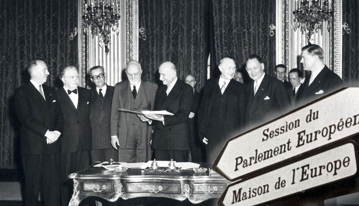
On November 1, 1993, the Maastricht Treaty officially established the European Union (EU), marking a transformative milestone in modern political and economic history. The agreement brought together 12 European nations under a unified structure, fostering economic cooperation, shared governance, and collective security. It introduced the concept of...
Read More →
On November 17, 1994, the Peshawar Development Authority (PDA) began its first Ring Road Housing Expansion Scheme to reduce congestion inside the historical core of Peshawar. By the mid-1990s, Hayatabad, Gulbahar and inner Saddar were experiencing severe residential pressure due to migration from tribal districts and rising commercial activity. The...
Read More →
On 6 December 2022, the United Kingdom’s historic weekly real estate journal Estates Gazette (EG) announced that, due to severe financial pressures, it was no longer possible to continue its traditional mode of publication. The management acknowledged that a sustained decline in advertising revenue, increasing financial strain on print media, and...
Read More →
On 27 November 1962, the Lahore Improvement Trust (LIT) issued a landmark resolution approving, for the first time, the formal urban expansion of Lahore across the western bank of the Ravi River (towards Shahdara). This decision emerged at a time when Lahore was confronting rapid population growth, the housing pressures of post Partition migration,...
Read More →
The acquisition of land for the Model Town Society was one of the most remarkable and spirited chapters in its early history. Dewan Khem Chand and his...

Between 1921 and 1924, the land for Model Town Lahore was acquired in successive phases. The process began in 1921, shortly after the establishment of...
No comments yet. Be the first to comment!