
Syed Shayan Real Estate Archive
Syed Shayan Real Estate Archive
From Real Estate History
11 Historical Event found
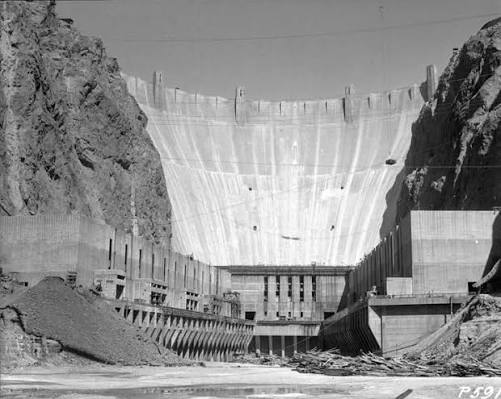
Hoover Dam was named after Herbert Hoover, the 31st President of the United States, who strongly supported the project before becoming president. The dam was also called Boulder Dam for some years, but in 1947 the U.S. Congress officially restored the name Hoover Dam. Preliminary construction work began at Hoover Dam on the Colorado River on 7th july 1930, marking the start of a project that would reshape the economic and real estate geography of the American Southwest. Built during the Great Depression, the dam was not merely an engineering achievement; it became a foundation for urban expansion, land development and long-term regional planning. Before Hoover Dam, the Colorado River was both a source of opportunity and a recurring threat. Seasonal floods damaged farms, settlements and infrastructure, while large desert areas remained difficult to develop due to unreliable water supply. The dam changed that equation by controlling floods, storing water, generating hydroelectric power and supporting large-scale irrigation. Its impact on real estate was historic. Reliable water and electricity made it possible for cities, towns and agricultural communities in Nevada, Arizona and Southern California to expand with greater confidence. Land that was once considered risky or unsuitable for settlement became more valuable as infrastructure improved. Housing, commercial districts, farming settlements and industrial activity all benefited from the stability created by the dam. The project also played an important role in the development of Las Vegas and nearby planned communities. Boulder City, originally built to house dam workers, became a model of planned urban settlement linked directly to a major infrastructure project. Over time, the availability of power and water helped support population growth, tourism, construction and investment across the region. In real estate history, Hoover Dam stands as a reminder that property markets do not grow through land alone. They grow through infrastructure, water security, energy supply, connectivity and state planning. The project showed how one strategic public works initiative could transform desert land into a powerful economic corridor.
Read More >
1979: The Hoboken Land and Improvement Company Building in New Jersey was added to the National Register of Historic Places, recognising its architectural, commercial and urban development significance. Built in 1889, the building served as the office of the Hoboken Land and Improvement Company, a real estate holding company linked to the Stevens family. The company played an important role in shaping the growth of Hoboken by managing land, supporting development and helping guide the city’s transformation into a key urban and commercial area. The building is also notable for its high quality brickwork and historic character, reflecting the commercial architecture of the late nineteenth century. Its preservation highlights the importance of protecting buildings connected not only to architecture, but also to land ownership, city planning and real estate development. Today, the Hoboken Land and Improvement Company Building remains an important reminder of how private landholding companies influenced urban expansion in the United States. Its listing on the National Register of Historic Places marked a key step in recognising the link between real estate history and historic preservation.
Read More >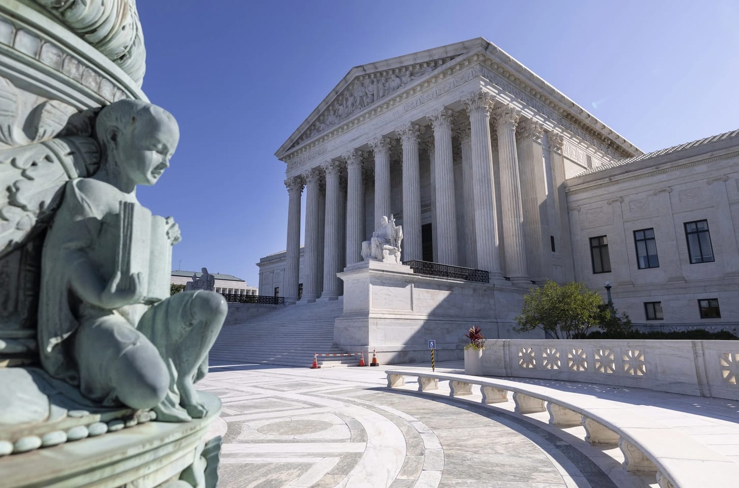
On June 17, 1968, the U.S. Supreme Court delivered an important decision in Jones v. Alfred H. Mayer Co., strengthening fair housing rights in the United States. The Court ruled that racial discrimination in the sale or rental of property was illegal, including discrimination by private property owners. The decision reinforced the Civil Rights Act of 1866 and became a major step toward equal housing opportunities and protection against racial bias in the real estate market.
Read More >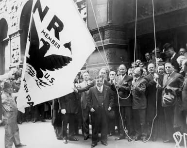
On 16 June 1933, U.S. President Franklin D. Roosevelt signed the National Industrial Recovery Act (NRA), one of the major laws of the New Deal era. The law was introduced during the Great Depression to revive the economy, support employment and encourage large scale public works. For real estate and urban development history, the law holds special importance because it helped establish the Public Works Administration, which supported major construction projects, including highways, public buildings, schools, hospitals and infrastructure works. Britannica describes the PWA as a New Deal agency designed to reduce unemployment and increase purchasing power through construction activity. The law also created space for early public housing efforts. Historical records show that public works under the programme included low-cost housing and slum-clearance projects, making it an important step in the evolution of government-backed housing and urban renewal policy. In real estate history, 16 June 1933 is remembered as a day when housing, construction and infrastructure were treated not only as property-sector issues but also as tools for economic recovery, employment generation and urban development. This approach later influenced public housing and city planning policies in different parts of the world.
Read More >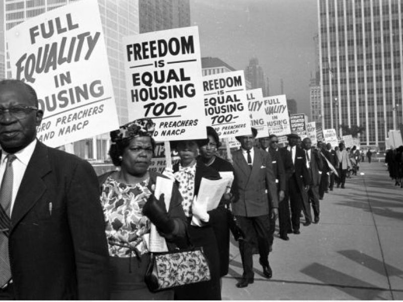
On 5 December 1957, New York City became the first city in the United States to enact legislation prohibiting racial and religious discrimination in the housing market. On this date, the New York City Council approved the Fair Housing Practices Law, which made it unlawful to discriminate in the sale, purchase, or rental of housing on the grounds of colour, race, or religion. The necessity for this legislation arose in the period following the Second World War, when racial and religious discrimination had become entrenched within the housing markets of major American cities. Property owners and real estate agents routinely prevented African American residents, Jewish families, and other minority groups from purchasing or renting homes in certain neighbourhoods. This practice led to the emergence of segregated residential areas and exposed a fundamental contradiction within American society: citizens were legally equal, yet denied equality in access to housing. This persistent injustice, combined with the growing civil rights movement, made the introduction of fair housing legislation both urgent and unavoidable. The decision represented a significant milestone in the history of civil rights in the United States. For the first time, a major city adopted a clear and formal legal position against discrimination within the private housing sector. The law provided statutory recognition to the principle of fair housing and formally aligned the housing market with broader commitments to social equality and civil rights. Later in December 1957, the legislation came into force as a local law. Nevertheless, in historical and policy terms, 5 December 1957 is recognised as the moment when New York laid the foundation for the legal prohibition of discrimination in housing. In subsequent years, this law served as an important precedent for fair housing legislation across the United States and influenced reforms introduced at the federal level.
Read More >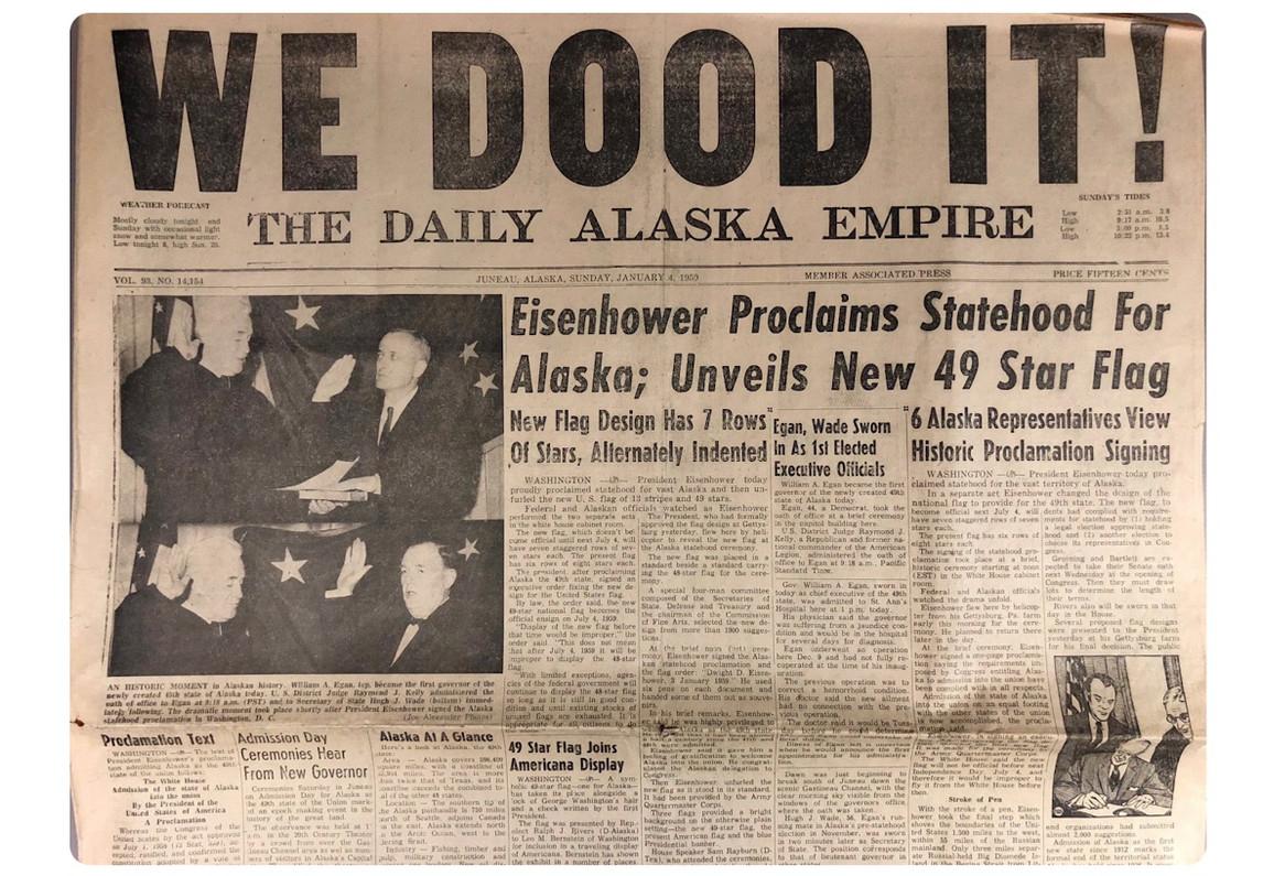
3 January 1959 marks not merely the admission of Alaska as the forty ninth state of the United States, but a historically significant moment representing the transfer of ownership of one of the largest landmasses in modern history. Prior to attaining statehood, Alaska formed part of the Russian Empire and was known as Russian America. Russian explorers first arrived in the region during the eighteenth century, with their primary interest centred on the lucrative fur trade. Over time, however, this trade declined steadily, reducing the region’s economic value for Russia. Given Alaska’s extreme geographical distance from the Russian mainland, its administration and defence became increasingly costly and impractical. These challenges were compounded by concerns that, in the event of a conflict, Britain, then in control of Canada, could readily seize the territory. Under these circumstances, Russia concluded that selling the territory to a friendly power would be the most prudent course of action. Consequently, in 1867, Alaska was sold to the United States for a sum of 7.2 million dollars. At the time, the agreement was widely criticised within the United States and derisively labelled Seward’s Folly, after the then Secretary of State, William H. Seward, who negotiated the deal. In later years, however, the discovery of gold, oil and other valuable natural resources transformed this transaction into one of the most advantageous territorial acquisitions in recorded history. Alaska covers a total area of approximately 375 million acres. With the granting of statehood, the Alaska Statehood Act introduced an unprecedented provision under which the new state was authorised to select and acquire approximately 102 to 103 million acres of federal land. Never before in American history had such an extensive transfer of land been executed under a single legal framework. This decision laid the foundations for structured urban infrastructure, town planning and commercial zoning during Alaska’s formative years as a state. [img:Images/3-jan-2-otd.jpeg | desc:Alaska Territorial Gov. Bob Bartlett in center, with the 49-star flag (Bartlett was one of Alaska’s first U.S. senators).] Before statehood, the value of Alaska’s land was largely associated with gold mining and a limited range of mineral resources. After 1959, however, systematic government surveys, land leasing policies and formal land selection processes brought the region firmly into the focus of investors. Just a few years later, in 1968, the discovery of vast oil reserves in the Prudhoe Bay area fundamentally redefined the economic significance of the land. A barren and frigid region long considered unsuitable for large scale use suddenly emerged as a centre of global energy production. This transformation elevated Alaska’s commercial land to strategic value measured in trillions of dollars. Following statehood, federal funding accelerated the development of infrastructure, leading to a substantial and decisive rise in land values. Major urban centres such as Anchorage witnessed the establishment of planned housing developments, encouraging organised urban expansion and residential growth. Similarly, the expansion of residential and commercial construction in Fairbanks stimulated economic and social activity in northern regions, improving living standards for local communities and contributing to the state’s overall development. The construction of roads and transportation networks made previously inaccessible land usable, overcoming geographical barriers that had long restricted development. Statehood also gave rise to significant disputes over land rights, as the historical claims of Indigenous populations conflicted with federal and state land selection processes. To address these issues, the Alaska Native Claims Settlement Act was enacted in 1971, under which approximately forty four million acres of land were transferred to Native tribal corporations.
Read More >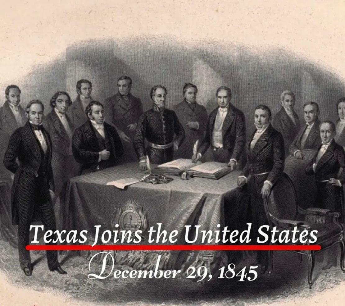
On 29 December 1845, Texas formally became the twenty eighth state of the United States. This event was not merely a political decision. It marked an extraordinary turning point in the global history of land ownership and real estate. As a result of this single day’s decision, approximately 259000 square miles, or nearly 695000 square kilometres, came under the jurisdiction of the American federal system. Texas held a unique position because it had previously existed as an independent republic. The land was already settled. Agriculture was actively practised. Claims of private as well as communal ownership were firmly in place. When Texas was annexed by the United States, all these lands were brought under the American constitutional and legal framework in a single moment. This transition reshaped land registration, land claims, agricultural ownership, and future urban planning within an entirely new framework influenced by American legal culture. Concepts of ownership, legal documentation, boundary demarcation, and patterns of urban expansion shifted from local traditions to align with the federal American system. The historical importance of this annexation is further underscored by the fact that it represented the largest territorial addition ever gained through the admission of a sovereign state into the United States. At the time, the area exceeded that of several European countries and opened the path for the expansion of the American property market towards the southern and western regions. In subsequent decades, these lands formed the foundation for vast agricultural estates, railway networks, industrial centres, and newly established cities. One of the most significant outcomes of Texas’s annexation for the United States was the acquisition of an extensive coastline, providing strong and direct access to the Gulf of Mexico. This geographical transformation also produced a broader economic benefit for landlocked states. The development of ports along the Texas coast created new and more accessible routes for the agricultural and industrial output of inland regions to reach global markets. Over time, as expansive railway networks and integrated river systems connected these landlocked states to the Texas coastline, interior regions became part of the global trade system. In this way, the annexation of Texas emerged as a gradual yet profoundly significant milestone in the overall economic growth of the United States.
Read More >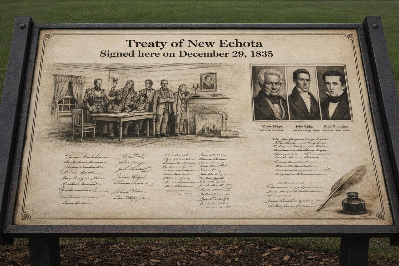
On 29 December 1835, a legal treaty was concluded in the American state of Georgia, historically known as the Treaty of New Echota. This agreement is regarded as one of the most controversial and troubling chapters in United States history, particularly in relation to land ownership, state authority, and the rights of Indigenous nations. By the early nineteenth century, the south eastern states of the United States, especially Georgia, Alabama, and Tennessee, had become centres of an expanding agricultural economy. Cotton cultivation, commonly referred to as the Cotton Economy, was growing rapidly, leading to an exceptional demand for fertile land. Large tracts of this land were owned by Indigenous communities, most notably the Cherokee Nation. Their continued presence was increasingly viewed as an obstacle to the American policy of westward territorial expansion. Within this context, the United States Congress passed the Indian Removal Act in 1830, which provided the legal framework for the forced relocation of Indigenous peoples from east of the Mississippi River to lands further west. The Treaty of New Echota emerged as a direct outcome of this policy. The treaty was finalised on 29 December 1835 at New Echota, which was then the capital of the Cherokee Nation. Under its terms, the Cherokee ceded all their lands east of the Mississippi River to the United States government. This territory amounted to approximately seven million acres. In return, the government promised compensation of five million dollars and the allocation of alternative land in the west. This land lay within the area of present day Oklahoma, known at the time as Indian Territory. From a legal perspective, the most contentious aspect of the treaty concerned the issue of representation. The agreement was not signed by the elected leadership or the national council of the Cherokee Nation. Instead, it was endorsed by a small political faction, later known as the Ridge Party, whose members included Major Ridge, John Ridge, Elias Boudinot, and Stand Watie. The principal chief of the Cherokee Nation, John Ross, along with the majority of the national council, rejected the treaty as invalid and contrary to the collective will of the people. The United States was represented in the negotiations by John F. Schermerhorn, a federal commissioner. Despite widespread opposition among the Cherokee population, the United States Senate ratified the treaty by a margin of just one vote. This ratification elevated the agreement to the status of federal law and paved the way for the use of state force. When a large proportion of the Cherokee people refused to comply with the treaty and abandon their ancestral lands, the United States military initiated a programme of forced removal. Between 1838 and 1839, thousands of Cherokee men, women, and children were gathered into detention camps and subsequently transported westwards. This episode became known in history as the Trail of Tears. Historical records indicate that approximately sixteen thousand Cherokee individuals were forcibly displaced from their homelands. The journey covered an average distance of twelve hundred miles and was undertaken on foot, by riverboats, and with limited means of transport. Severe weather conditions, inadequate food supplies, disease, and poor administration resulted in the deaths of an estimated four thousand people. In the Cherokee language, this journey is remembered as Nu na da ut sun y, meaning the place where they cried. After arriving in the west, the Cherokee Nation re established its political and social institutions in Oklahoma. Tahlequah was designated as the new capital, and systems of constitutional governance, courts, educational institutions, and newspapers were rebuilt. Nevertheless, their legal ownership of their former eastern lands was considered permanently extinguished. The legacy of this treaty has not entirely faded in the modern era. In 2020, the United States Supreme Court, in the case of McGirt v. Oklahoma, affirmed that large parts of Oklahoma legally remain tribal reservation land, as earlier treaties had never been formally revoked. This ruling carried significant implications for land rights, jurisdiction, and property law. [img:Images/2nd-image-29-dec.jpeg | desc:The Treaty of New Echota and the subsequent forced removal of the Cherokee people have been the subject of numerous serious documentary films and historical reconstructions based on official records and archival evidence. Notable among these are Trail of Tears: Cherokee Legacy and the PBS series We Shall Remain, which examine the legal and political consequences of the Indian Removal Act and the Treaty of New Echota. These works illustrate how treaties and federal policy were used to reshape patterns of land ownership and population geography. ] The Treaty of New Echota has been included in the Syed Shayan Real Estate Archives to serve as a reminder of how state policy, legal instruments, and economic interests can combine to dispossess ordinary people of their land.
Read More >US President Ulysses S. Grant signed the Yellowstone National Park Protection Act on 1 March 1872, thereby formally creating the world’s first national park. One day earlier, on 28 February 1872, the United States Congress had approved the bill. With the President’s signature, the area was permanently designated as a national park. The idea of Yellowstone first emerged during the 1871 expedition led by geologist Dr Ferdinand V. Hayden and his scientific team, who conducted a detailed survey of the region. Their report and photographic documentation convinced Congress that this extraordinary natural landscape should be preserved rather than opened for private ownership or settlement. On this basis, it was declared a “public park for the benefit and enjoyment of the people.” Yellowstone National Park covers approximately 2.2 million acres, or about 8,991 square kilometres. The area spans parts of the present day states of Wyoming, Montana, and Idaho. It is home to hot springs, geysers, dense forests, mountains, rivers, and rare wildlife species. It was this unique natural beauty and scientific significance that led to the decision to protect it. [img:Images/otd-2-mar-2nd.jpeg | desc:(National Park refers to an extensive natural territory within a sovereign state that is formally designated and protected through statutory law, ensuring the preservation of its ecological integrity, scenic landscapes, wildlife habitats, mountain systems, forests, wetlands, rivers, and broader environmental character.Such land is not ordinarily opened to private acquisition, speculative real estate development, housing schemes, or industrial construction. Instead, it is institutionally reserved for public benefit, ecological conservation, regulated tourism, environmental education, and scientific research, thereby safeguarding it as part of the nation’s natural heritage for present and future generations.In Pakistan, several National Parks have been established under federal and provincial legal frameworks, including Hingol National Park, Khunjerab National Park, Lal Suhanra National Park, Margalla Hills National Park, and Ayubia National Park, each representing a distinct ecological zone within the country’s environmental geography.When observing satellite imagery through platforms such as Google Earth, one often notices a prominent green demarcated expanse labeled “National Park.” This cartographic distinction signifies a legally protected landscape, formally set aside by the state in the collective public interest and for long term environmental stewardship.Syed Shayan Archive Editorial Head)] The most remarkable aspect of the legislation was that, for the first time, a country set aside such a vast tract of land not for sale, settlement, or commercial exploitation, but as a preserved public trust. It was protected so that future generations could benefit from it. This philosophy later became the foundation for land use regulation, zoning laws, and environmental protection policies. Today, Yellowstone National Park is managed by the National Park Service, which was established in 1916 and operates under the United States Department of the Interior. In addition, scientific research and documentation have been supported by global institutions such as National Geographic, which has played a significant role in highlighting the park’s international importance.
Read More >
Prior to Florida’s admission, the United States consisted of 26 states. Its elevation to statehood was driven in part by the need to preserve the delicate political balance between slave holding and free states. As a southern territory that permitted slavery, Florida’s admission was paired with that of a free state to maintain equilibrium in the United States Senate. Florida encompasses approximately 170,312 square kilometres, or roughly 42 million acres, giving it substantial geographic scale along with an extensive and strategically significant coastline. In its early development, Florida was widely recognised for its fertile agricultural land, particularly its citrus groves and large scale farming estates. However, during the twentieth century, its identity gradually shifted as coastal development accelerated. Residential and leisure oriented properties began to dominate its shoreline, redefining the state’s economic and social character. The growth of coastal destinations such as Miami Beach and Palm Beach helped establish Beachfront property as a distinguished global investment category. In these areas, land value came to be determined not solely by size but by ocean frontage, climate, direct beach access, and the prestige associated with a luxury coastal lifestyle. The expansion of hotels, resorts, entertainment venues, and high end residential projects further elevated seaside real estate into a recognised status symbol. Florida’s real estate legacy is also closely associated with the Florida Land Boom of the 1920s. During this period, land speculation intensified dramatically, and coastal property prices surged at an unprecedented pace. Large scale advertising campaigns promoted rapid wealth through land ownership, and pre construction sales became a common practice. It was during this era that purchasing land primarily as an investment rather than solely for personal residence gained widespread acceptance. This model later influenced coastal developments around the world, positioning Florida as a formative example in the evolution of modern real estate marketing. Today, Florida remains renowned for its residential developments, luxury coastal properties, retirement communities, and tourism driven commercial real estate. Many billionaires reside in the state, including former United States President Donald Trump, whose residence, Mar a Lago, is located in Florida.
Read More >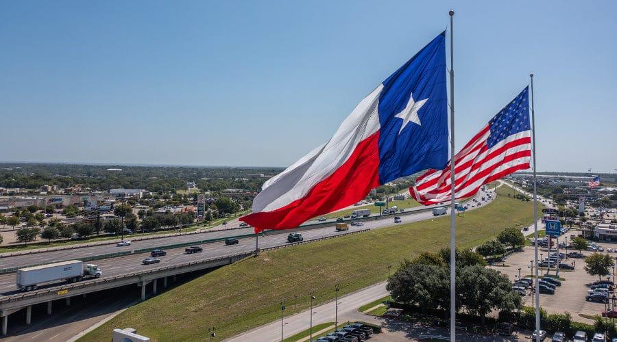
The United States Congress gave final legislative approval to the Joint Resolution providing for the annexation of Texas, marking a decisive moment in American territorial expansion. The process had begun a day earlier, on 27 February, when the Senate passed the resolution by a narrow margin of 27 to 25. The vote was initially tied, but one senator changed his position, allowing the measure to pass by a two vote difference. The following day, the House of Representatives approved the Senate version by 132 votes to 76, completing congressional action. On 1 March 1845, President John Tyler signed the resolution into law. At the time of annexation, the United States consisted of 27 states. Texas entered the Union as the 28th state. With an area of approximately 695,662 square kilometres, its admission significantly expanded the territorial footprint of the country. This was not merely a symbolic addition to the map. The territory carried immense economic potential, including vast agricultural lands, mineral resources, and, in later decades, major oil and gas discoveries. Following annexation, land settlement and distribution accelerated. Although Texas retained control over much of its public domain, integration into the American system encouraged structured land grants, railroad allocations, new town development, and organised settlement patterns. In subsequent years, federal legislation such as the Homestead Act widened access to land ownership and contributed to the long term expansion of the American real estate market. Today, Texas remains one of the largest and most influential real estate markets in the United States by area and economic activity. While California and New York typically command higher land values in absolute price terms, Texas ranks first in total agricultural land area and continues to hold strategic importance due to its industrial base and energy sector.
Read More >