
Syed Shayan Real Estate Archive
Syed Shayan Real Estate Archive
From Real Estate History
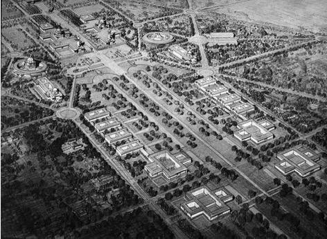
On 29 November 1912, a decisive notification was published in Part One of the Government of India Gazette, establishing the legal basis for the large scale acquisition of government land required for the construction of New Delhi, the new capital of British India.
This notification followed the Delhi Durbar of 1911, during which King George V announced the transfer of the capital from Calcutta to Delhi. The British administration was therefore required to identify an appropriate site and secure the necessary land without delay for the establishment of the new city.
According to the notification, and under Sections Three and Six of the Land Acquisition Act of 1894, the southern suburban districts of Delhi were declared compulsory acquisition zones. These included extensive tracts covering Raisina Hill, Malcha, the Revenue District of Mehrauli, and areas extending to the western bank of the River Yamuna.
The land identified for acquisition comprised all those areas selected for the Viceroy’s House, the Central Secretariat, the Civil Lines extension, the Central Avenue, and the wider administrative framework of the proposed capital. The notification made clear that New Delhi was not intended merely as a political centre, but as a modern, comprehensively planned urban seat of government, designed to accommodate administrative institutions, major boulevards, residential settlements and commercial districts.
Government records indicate that the land being acquired consisted largely of agricultural fields, woodland tracts and small rural settlements. These areas were incorporated into a consolidated urban scheme in accordance with the recommendations of the Town Planning Committee of 1912.
Through this notification, the Collector of Delhi was instructed to carry out all requisite procedures without delay, including land surveys, demarcation, mapping, valuation, verification of local records and completion of acquisition proceedings, to ensure the timely construction of Lutyens Delhi.
Lutyens Delhi refers to that part of New Delhi designed by the British architect Sir Edwin Lutyens. This area includes major government buildings such as the Viceroy’s House (present day Rashtrapati Bhavan), the Parliament House, the North Block, the South Block and the Central Secretariat. Its broad avenues and ordered urban layout continue to form the core of New Delhi’s administrative identity.
The Gazette notification of 29 November 1912 occupies a foundational place in the history of land acquisition, urban planning, colonial architecture and state control of territory in the Indian subcontinent.
These official British government records are preserved today in the National Archives of India and the India Office Records at the British Library, where the proceedings of 29 November 1912 are recognised as the formal beginning of the construction of New Delhi.
▪️Syed Shayan Real Estate Archive
▪ Reference(s):
29 نومبر 1912 کو گورنمنٹ آف انڈیا گزٹ پارٹ ون میں وہ فیصلہ کن نوٹیفکیشن شائع کیا گیا جس نے برطانوی ہند کے نئے دارالحکومت نئی دہلی کی تعمیر کے لیے سرکاری اراضی کے بڑے پیمانے پر حصول کی قانونی بنیاد فراہم کی۔
یہ نوٹیفکیشن 1911 کے دہلی دربار کے بعد سامنے آیا، جب بادشاہ جارج پنجم نے دارالحکومت کو کولکتہ سے دہلی منتقل کرنے کا اعلان کیا تھا اور برطانوی حکومت کو اس نئے شہر کے لیے مناسب جگہ کا انتخاب اور فوری اراضی کی فراہمی درکار تھی۔
نوٹیفکیشن کے مطابق Land Acquisition Act 1894 کی دفعہ تین اور چھ کے تحت دہلی کے جنوبی مضافاتی علاقوں کو لازمی حصول کی حدود میں شامل کیا گیا، جن میں Raisina Hill، Malcha، Revenue District Mehrauli، اور دریائے جمنا کے مغربی کنارے تک کے وسیع رقبے شامل تھے۔
حاصل کی جانے والی زمین میں وہ تمام علاقے شامل تھے جنہیں وائسرائے ہاؤس، مرکزی سیکریٹریٹ، سول لائنز، مرکزی ایونیو اور نئے انتظامی ڈھانچے کے لیے منتخب کیا گیا تھا۔ اس نوٹیفکیشن میں برطانوی حکومت نے واضح کیا کہ نئی دہلی صرف ایک سیاسی شہر نہیں ہوگا بلکہ جدید منصوبہ بندی سے بنایا گیا مرکزی شہری مرکز ہوگا جہاں سرکاری ادارے، شاہراہیں، رہائشی بستیاں اور تجارتی مراکز ہوں گے۔
گورنمنٹ ریکارڈ کے مطابق یہ اراضی زیادہ تر زرعی، جنگلاتی اور چھوٹے دیہاتی استعمال کی حامل تھی، جسے برطانوی حکومت نے ایک مربوط شہری منصوبے میں تبدیل کرنے کے لیے Town Planning Committee 1912 کی سفارشات پر شامل کیا۔
اس نوٹیفکیشن کے ذریعے کلکٹر دہلی کو ہدایت دی گئی کہ وہ فوری طور پر زمین کا سروے، حد بندی، نقشہ سازی، تخمینہ کاری، مقامی ریکارڈ کی تصدیق اور حصول کی کارروائی مکمل کرے، تاکہ ڈی لوٹیئنز دہلی بروقت تعمیر کیا جا سکے۔
ڈی لوٹیئنز (Lutyens Delhi) نئی دہلی کا وہ علاقہ ہے جسے برطانوی آرکیٹیکٹ سر ایڈون لوٹیئنز نے پلان کیا تھا۔ اس حصے میں وائسرائے ہاؤس (موجودہ راشٹرپتی بھون)، پارلیمنٹ ہاؤس، نارتھ بلاک، ساوتھ بلاک اور مرکزی سیکریٹریٹ جیسی اہم سرکاری عمارتیں بنائی گئیں۔ چوڑی سڑکوں اور منظم اربن پلان کی وجہ سے یہ علاقہ آج نئی دہلی کی اہم سرکاری سرگرمیوں کا مرکز ہے۔
29 نومبر 1912 کا یہ گزٹ نوٹیفکیشن برصغیر کی اراضی کے حصول، شہری منصوبہ بندی، نوآبادیاتی طرزِ تعمیر اور زمین کے ریاستی کنٹرول کی تاریخ میں بنیادی اہمیت رکھتا ہے۔
برطانوی حکومت کے یہ سرکاری ریکارڈ آج نیشنل آرکائیوز آف انڈیا اور برٹش لائبریری کے India Office Records میں محفوظ ہیں، جہاں 29 نومبر 1912 کی اسی کارروائی کو نئی دہلی کے قیام کی اصل بنیاد تصور کیا جاتا ہے۔
▪️ سید شایان ریئل اسٹیٹ آرکائیو
▫This decision is regarded as one of the most consequential developments of its era, shaping the historical geography of land, real estate, urban division, agricultural territory, industrial regions, coastal zones and the boundaries that connected transport routes across the region.
▫The refusal to accept this resolution has shaped the Palestinian experience ever since.
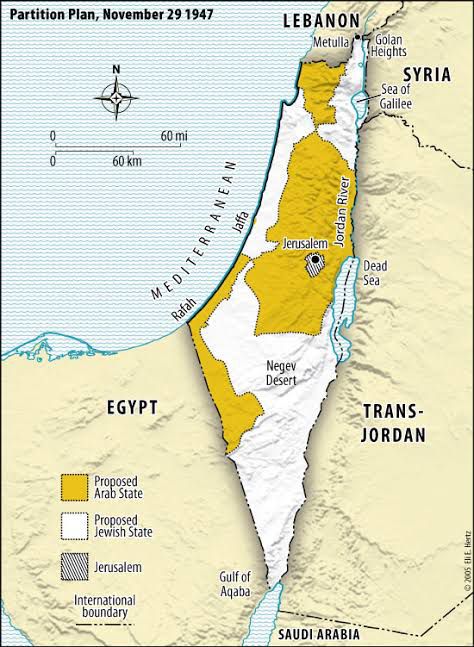
On 29 November 1947, during its second session, the United Nations General Assembly adopted Resolution one hundred and eighty one, known internationally as the United Nations Partition Plan for Palestine. Through this resolution, the Assembly recommended the division of British administered Palestine into two separate states, one Jewish and one Arab. The plan also proposed that Jerusalem and Bethlehem be placed under an International Trusteeship in recognition of their religious significance and administrative sensitivity, thereby placing them under international supervision.
The resolution received thirty three votes in favour, thirteen against, while ten states abstained.
The plan was presented to the General Assembly by the United Nations Special Committee on Palestine, established in May nineteen forty seven. The committee consisted of eleven neutral countries and was mandated to recommend an international solution for the political future of Palestine following the end of the British Mandate. Over several months, the committee conducted extensive field visits, hearings and inquiries across Palestine, and eventually submitted its final report. The report included maps, boundary lines, the proposed division of the territory, and detailed allocations of agricultural land, industrial areas, coastal regions and transport corridors. It is considered one of the most comprehensively documented land division plans of the modern century and represented the first time that the future territorial shape of a region was determined through an international vote.
The plan, however, was never implemented. The Arab states and the Palestinian leadership rejected it as unjust, and following the war of nineteen forty eight, Israel took control of far more territory than had been assigned under the resolution.
In the years that followed, the nineteen forty nine Green Line, the nineteen sixty seven war, subsequent military occupations, political negotiations and the Oslo process created the borders and administrative arrangements that exist today. These territorial realities do not follow the lines proposed in Resolution one hundred and eighty one.
For Palestine, the rejection of the resolution resulted in the loss of the state envisaged for it. The wars of nineteen forty eight and nineteen sixty seven deepened this loss. Almost all land allocated to the Arab state came under Israeli control. The nineteen forty nine Green Line further confined Palestinian territory, while the post nineteen sixty seven arrangements fragmented Gaza, the West Bank and Jerusalem into separate and often disconnected zones. The vision of a unified and sovereign Palestinian state remained limited to documents and maps.
In the present moment, after the most prolonged and destructive conflict of recent history, from twenty twenty three to twenty twenty five, both Palestine and Israel stand in a state of devastation. The coastal territory of Gaza has been almost entirely destroyed. It is this shattered landscape that the President of the United States, Donald Trump, has spoken of transforming into a Riviera once the war has ended.
(Official records of the United Nations, the General Assembly archives, Encyclopaedia Britannica, BBC Archives and the Al Jazeera Timeline all confirm this event as taking place on twenty nine November nineteen forty seven.)
▪️Syed Shayan Real Estate Archive
▪ Reference(s):
▫رئیل اسٹیٹ، زمین، شہروں کی تقسیم، زرعی اراضی، صنعتی خطے، ساحلی پٹی، نقل و حمل کے راستوں کے لیے boundaries اور عالمی جغرافیے پر اپنے وقت کی سب سے بڑی تاریخی خبر۔
▫اس قرارداد کو نہ ماننے کا خمیازہ آج تک فلسطین کو بھگتنا پڑ رہا ہے۔
29 نومبر 1947 کو اقوام متحدہ کی جنرل اسمبلی نے اپنے دوسرے سیشن میں قرارداد 181 منظور کی جسے عالمی تاریخ میں United Nations Partition Plan for Palestine کے نام سے جانا جاتا ہے۔ اس قرارداد کے ذریعے جنرل اسمبلی نے برطانوی زیرِ انتظام فلسطین کو دو الگ ریاستوں میں تقسیم کرنے کی سفارش کی: ایک یہودی ریاست اور ایک عرب ریاست۔ اس کے ساتھ ساتھ یروشلم اور بیت اللحم کے علاقے کو ایک International Trusteeship کے تحت رکھنے کی تجویز دی گئی، تاکہ مذہبی اہمیت اور انتظامی حساسیت کے باعث اسے عالمی نگرانی میں چلایا جا سکے۔
اس قرارداد کے حق میں 33 اور مخالفت میں 13 ووٹ آئے جبکہ 10 ممالک نے ووٹنگ سے اجتناب کیا۔
یہ تاریخی منصوبہ اقوام متحدہ کی جنرل اسمبلی کے سامنے خصوصی کمیٹی برائے فلسطین
United Nations Special Committee on Palestine (UNSCOP)
نے پیش کیا، جو مئی 1947 میں جنرل اسمبلی کی بنائی گئی ایک خصوصی کمیٹی تھی۔
اس کمیٹی میں گیارہ غیر جانب دار ممالک شامل تھے اور ان کا مقصد برطانوی مینڈیٹ کے خاتمے کے بعد فلسطین کے مستقبل کے سیاسی انتظام پر بین الاقوامی حل تجویز کرنا تھا۔ UNSCOP نے کئی ماہ تک فلسطین میں زمینی مشاہدہ، سماعتیں اور انکوائریاں کیں اور آخرکار اپنی حتمی رپورٹ پیش کی جس میں قرارداد کے نقشے، سرحدی لائنیں، ریاست کو دو حصوں میں تقسیم کرنے کی سفارش، زرعی اراضی، صنعتی خطے، ساحلی پٹی اور نقل و حمل کے راستوں تک کے لیے تفصیلی boundaries مقرر کی گئیں۔ یہ منصوبہ دنیا کے سب سے زیادہ documented land division plans میں شمار ہوتا ہے، جس میں پہلی مرتبہ کسی خطے کی مستقبل کی ریاستی شکل کو بین الاقوامی ووٹ کے ذریعے تعین کیا گیا۔
مگر یہ منصوبہ کبھی نافذ نہ ہو سکا۔ عرب ریاستوں اور فلسطینی قیادت نے اسے ناانصافی قرار دے کر مسترد کیا، اور 1948 کی جنگ کے بعد اسرائیل نے قرارداد میں دی گئی حد بندیوں سے کہیں زیادہ علاقہ اپنے کنٹرول میں لے لیا۔
بعد ازاں 1949 کی گرین لائن، 1967 کی جنگ، فوجی قبضوں، سیاسی مذاکرات اور اوسلو معاہدوں کے نتیجے میں موجودہ اسرائیلی اور فلسطینی حدود قائم ہوئیں، جو قرارداد 181 کے نقشے کی پیروی نہیں کرتیں۔
فلسطین کو قرارداد 181 کے نہ ماننے پر بعد اپنی مجوزہ ریاست سے محرومی کا سامنا ہوا اور 1948 اور 1967 کی جنگوں نے اس نقصان کو مزید بڑھا دیا۔ عرب ریاست کے لیے مختص علاقہ عملی طور پر اسرائیلی قبضوں میں چلا گیا، 1949 کی گرین لائن نے فلسطینی سرزمین کو محدود کر دیا اور 1967 کے بعد کے کنٹرول نے غزہ، ویسٹ بینک اور یروشلم کو الگ الگ انتظامات میں تقسیم کر دیا۔ یوں ایک مکمل اور خود مختار فلسطینی ریاست کا تصور کاغذی نقشوں تک محدود ہو کر رہ گیا۔
آج کی صورت حال یہ ہے کہ تاریخ کی موجودہ طویل ترین اور تباہ کن جنگ (2023-2025) کے بعد فلسطین اور اسرائیل دونوں بربادی کی کیفیت میں کھڑے ہیں، خاص طور پر غزہ کی ساحلی پٹی مکمل طور پر اجڑ چکی ہے۔ اور اسی تباہ شدہ خطے کے بارے میں اب امریکی صدر ڈونلڈ ٹرمپ یہ بات کر رہے ہیں کہ جنگ کے بعد یہاں ایک Riviera بنایا جا سکتا ہے۔
(قوام متحدہ کی آفیشل دستاویزات، جنرل اسمبلی کے ریکارڈ، Encyclopaedia Britannica، BBC Archives اور Al Jazeera Timeline سب اس واقعے کو 29 نومبر 1947 کی تاریخ پر کنفرم کرتے ہیں۔)
▪️ سید شایان ریئل اسٹیٹ آرکائیو
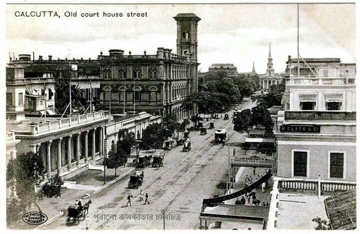
On October 10, 1924, the Registrar of Co-operative Societies in the Bengal Presidency recorded one of the earliest applications for a Residential Cooperative Housing Society in Calcutta, now Kolkata. This marked a turning point in South Asia’s urban development when the cooperative principle, previously used for credit and agriculture, was extend...
Read More →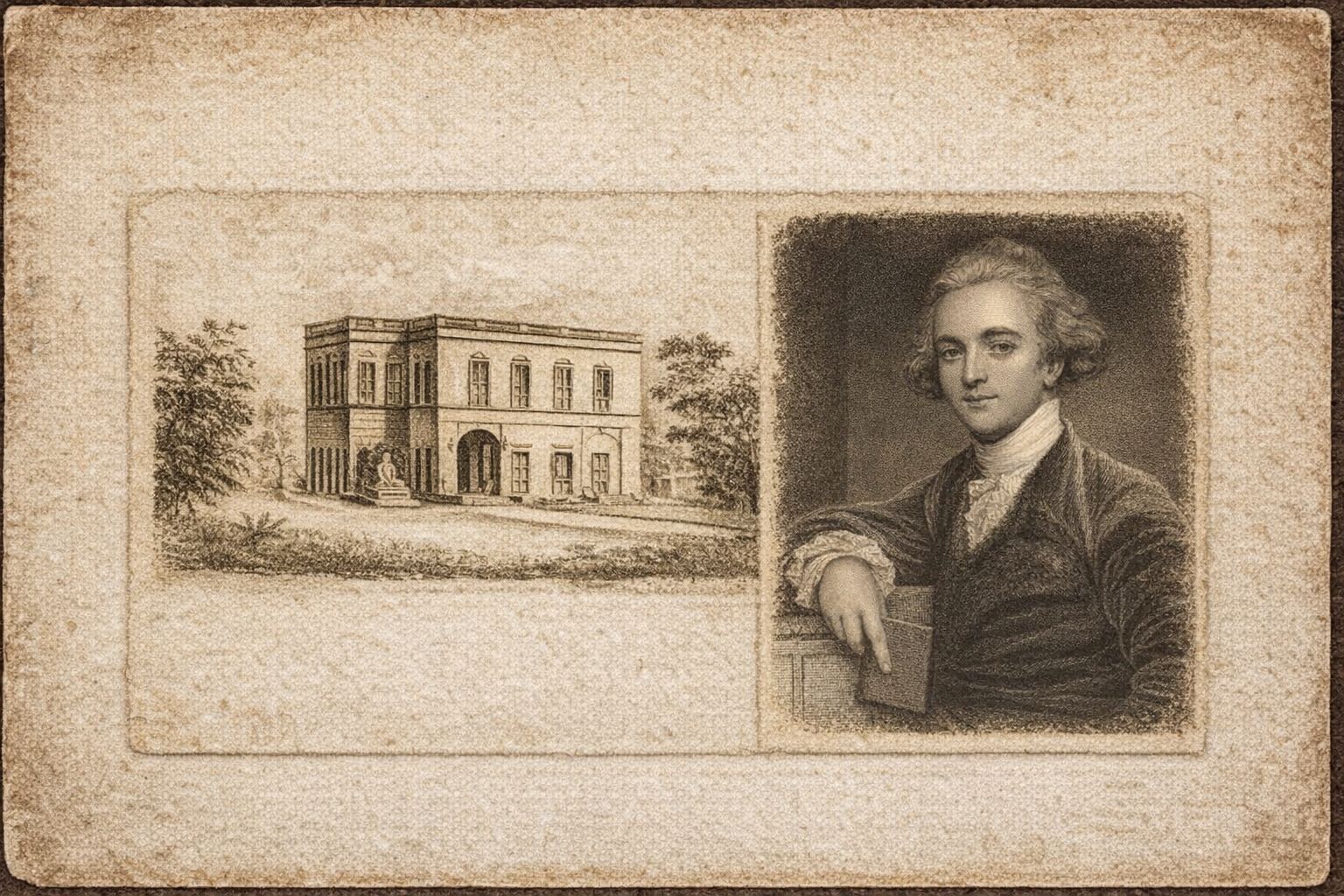
Exactly 242 years ago, on 15 January 1784, the Asiatic Society of Bengal was founded in Calcutta by Sir William Jones. On the same day, the Society convened its first formal meeting. The institution emerged as the earliest organised centre in the subcontinent dedicated to the systematic study of ancient manuscripts, archaeology, and geographical kn...
Read More →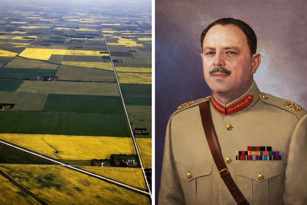
In the agrarian history of Pakistan, 8 January 1959 stands as a moment of enduring significance. On this date, the military government of Muhammad Ayub Khan announced the first comprehensive land reforms in the country’s history. These reforms were designed to curtail the entrenched feudal order and to relocate land ownership from the realm of ...
Read More →
According to the notification published in Part One of the Government of India Gazette on 28 November 1903, the East Indian Railway authorised for the first time an extensive acquisition of state land in the stretch between Howrah and Liluah. The measure was undertaken under Section Six of the Land Acquisition Act of 1894 and its principal purpose ...
Read More →
On November 11, 1894, the British Parliament approved the London Housing Reform Act to address worsening living standards in industrial London. The nineteenth century had transformed the city into a dense, polluted metropolis where entire families were crowded into small, unsanitary tenements. Poor ventilation, unsafe structures, and limited access...
Read More →
The acquisition of land for the Model Town Society was one of the most remarkable and spirited chapters in its early history. Dewan Khem Chand and his...

Between 1921 and 1924, the land for Model Town Lahore was acquired in successive phases. The process began in 1921, shortly after the establishment of...
No comments yet. Be the first to comment!