
Syed Shayan Real Estate Archive
Syed Shayan Real Estate Archive
From Real Estate History
6 Historical Event found
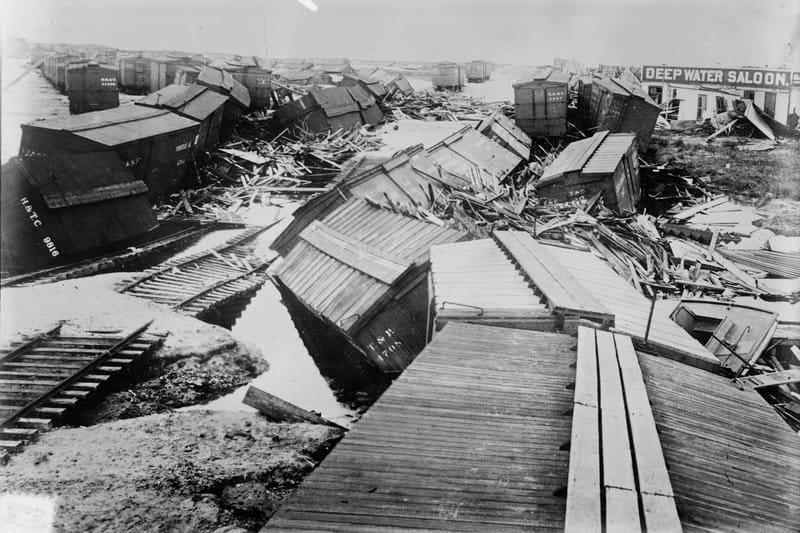
On September 8, 1900, the devastating Galveston Hurricane struck Galveston, Texas, becoming one of the deadliest natural disasters in U.S. history. The disaster was also a defining moment in the history of property, urban planning, construction and coastal real estate. The hurricane destroyed 2,636 houses in Galveston and damaged thousands of additional buildings. Property losses were estimated at approximately $28–30 million at the time—a staggering amount for 1900. What makes the event particularly significant for real estate is what happened after the disaster. Instead of simply rebuilding the destroyed properties, Galveston undertook one of the most extraordinary urban-engineering projects of its era. The city constructed a massive seawall, initially about six miles long and 17 feet above mean low tide, while large sections of the city were physically raised above the existing ground level. The scale of the reconstruction was extraordinary. Sand was pumped from the Gulf to raise the city's grade by as much as 17 feet, and 2,146 buildings had to be raised, along with streetcar tracks, fireplugs and water pipes. Even a 3,000-ton church was lifted with jacks and had fill pumped underneath it. The September 8, 1900 disaster fundamentally changed the way Galveston approached coastal property development and urban resilience. It demonstrated that rebuilding after a catastrophic event could involve not merely replacing buildings, but completely redesigning the physical foundations and protective infrastructure of an entire city. The lessons remain highly relevant today for cities facing flooding, sea-level rise, extreme weather, coastal development and climate-related property risks. The U.S. National Weather Service describes the September 8, 1900 hurricane as the greatest natural disaster to strike the United States at the time, with at least 6,000 deaths.
Read More >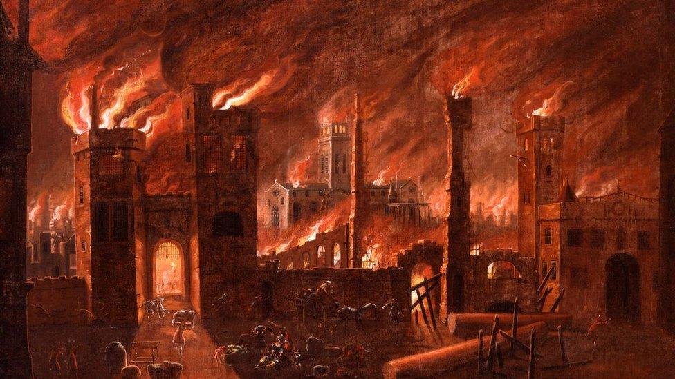
September 4, 1666, stands as an important date in global real estate and urban history. On this day, the Great Fire of London reached its peak after starting two days earlier. The fire swept through major parts of the City of London, destroying important commercial and civic areas including Cheapside, Guildhall and much of the area around St Paul’s Cathedral. The disaster had a profound impact on housing and property. Around 13,200 houses, 87 churches and large parts of the City were destroyed, leaving roughly 100,000 people homeless. Much of London’s building stock consisted of timber structures packed along narrow streets, conditions that allowed the flames to spread rapidly. The rebuilding challenge soon became much more than replacing destroyed homes. It became an opportunity to introduce stronger rules for the built environment. The Rebuilding Act of 1667 required safer construction using brick and stone and introduced controls over building heights and urban density. Special Fire Courts were also established to settle disputes between landlords and tenants over rebuilding responsibilities and costs. The rebuilding of London therefore became an important milestone in the evolution of modern real estate regulation. The experience demonstrated that recovery after an urban disaster requires more than replacing buildings. It requires safer construction standards, organised urban planning and mechanisms for resolving property disputes. More than three centuries later, the legacy of the Great Fire remains visible in London’s architecture and planning framework, making September 4 a significant date for understanding how disaster can reshape the future of a city’s real estate landscape. The Birth of Modern Fire Insurance Before 1666, fire insurance did not exist. The financial ruin of the fire prompted entrepreneurs to find a solution to mitigate future risks. In 1680, Nicholas Barbon established the "Fire Office," the world's first property fire insurance company. To identify insured properties, companies created "fire insurance marks"—metal plaques affixed to the front of brick buildings. Because there was no public fire department, insurance companies formed their own private fire brigades to extinguish fires, but exclusively for buildings bearing their specific mark.
Read More >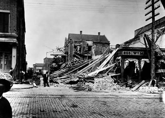
On August 31, 1886, a powerful earthquake struck Charleston, South Carolina, becoming one of the most significant natural disasters in the history of the eastern United States. The earthquake caused extensive damage across the city, severely affecting homes, commercial properties, churches and other masonry structures. Many buildings developed major cracks, while some collapsed completely. Property losses in Charleston were estimated at more than $5 million at the time, making the disaster a major economic setback for the city. The destruction highlighted a critical weakness in traditional construction: many buildings had not been designed to withstand powerful ground movement. Brick masonry structures were particularly vulnerable, while a number of wooden buildings performed comparatively better. The disaster demonstrated that construction materials, building foundations, workmanship and the overall strength of a structure can determine how well a property survives a natural disaster. In the aftermath, Charleston’s building owners and engineers began looking for ways to strengthen damaged structures. Iron rods and tie rods were installed in many masonry buildings to reinforce walls and improve their structural stability. These measures represented an early effort to make existing buildings more resistant to earthquake forces. The Charleston earthquake became an important historical lesson for the real estate and construction industries. It showed that property development cannot focus solely on appearance, location or economic value. Structural safety must be considered from the earliest stages of planning and construction. The event also contributed to a broader understanding of disaster-resistant construction. Over time, engineers developed stronger foundations, improved building materials, structural reinforcement techniques and construction standards designed to reduce earthquake damage. Today, earthquake-resistant design is an essential part of modern construction in regions exposed to seismic risks. Modern buildings are planned according to engineering principles that consider the movement of the ground and the ability of structures to absorb and withstand seismic forces. The Charleston earthquake therefore remains more than a historical disaster. It represents an important turning point in the development of safer construction practices and serves as a reminder that resilient buildings can protect both property investments and human lives.
Read More >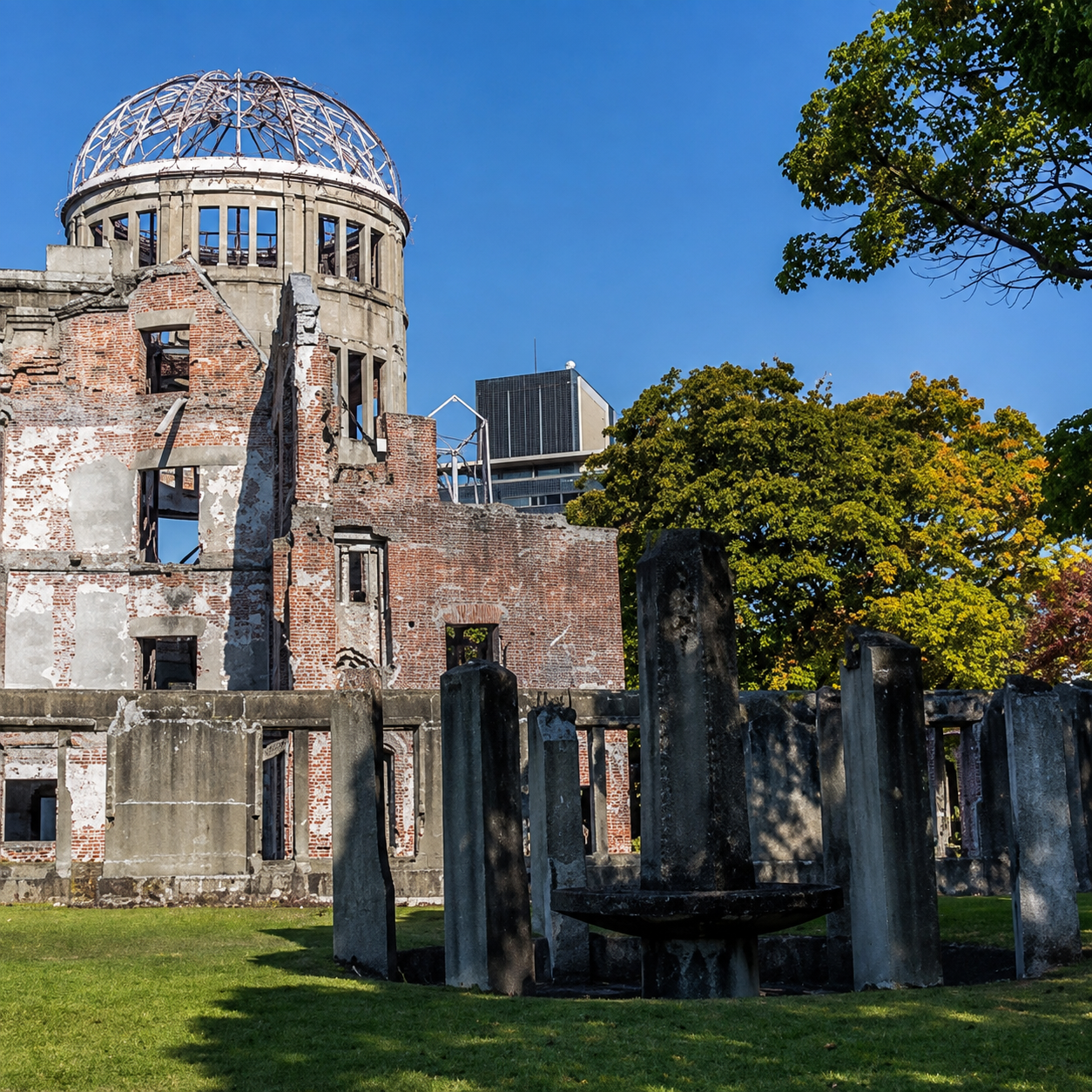
Japan enacted the Hiroshima Peace Memorial City Construction Law, establishing a special legal framework for the reconstruction, urban planning and redevelopment of Hiroshima after its destruction during the Second World War. Created under Article 95 of the Japanese Constitution, the legislation applied specifically to Hiroshima and came into force following a local referendum. It transformed the rebuilding of the city from a financially constrained municipal effort into a project supported by the national government. Hiroshima faced an acute shortage of financial resources, housing and functioning infrastructure after the war. The municipal government lacked sufficient funds to reconstruct roads, homes, drainage systems, schools and public facilities. Under the new law, former military sites and other nationally owned properties were transferred to the city as part of a preferential assistance programme. Official records show that approximately 35 hectares of state owned land were provided without compensation for educational facilities, water supply systems, sanitation services and welfare infrastructure. The legislation also led to the adoption of the Hiroshima Peace Memorial City Construction Plan in 1952. The plan proposed the development of Peace Memorial Park near the centre of the devastated city, the creation of major public parks and riverside green areas, the preservation of surrounding woodland and the construction of an efficient sewerage and drainage system. A grid based road network was designed around a 100 metre wide east to west boulevard running through the city centre. Land readjustment schemes were also used to reorganise damaged districts for housing, commercial activity, public services and transportation. The reconstruction programme supported the development of municipal housing, bridges, roads, parks and civic institutions. Among its early housing projects were the “Peace Apartments,” built beside the Kyobashi River in 1951. The development was Hiroshima’s first postwar municipal apartment complex constructed with reinforced concrete and represented an important step in restoring permanent urban housing. Hiroshima’s reconstruction remains significant in global real estate and urban development history because it demonstrated how destroyed urban land could be restored through special legislation, public land transfers, national subsidies and long term city planning. Rather than simply replacing damaged buildings, the programme reshaped the city around public spaces, modern infrastructure, environmental planning and a new civic identity. The law enacted on August 6, 1949 continues to serve as an important foundation for Hiroshima’s planning and development, showing how coordinated land policy and urban investment can transform a devastated city into a functioning and internationally recognised urban centre.
Read More >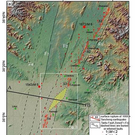
On the evening of 25 July 1668, a massive earthquake struck near Tancheng in present day Shandong province. Historical earthquake catalogues place the event near latitude 35 north and longitude 118.6 east and estimate its magnitude at 8.5. Modern researchers describe it as the largest known historical earthquake in eastern China and one of the most significant earthquakes recorded within the interior of a continent. The earthquake occurred along the Tan Lu fault system. Because scientific instruments did not exist at the time, specialists reconstructed its strength and location from official records, descriptions of collapsed buildings, changes in the ground and reports collected from affected districts. Research based on these archives continues to refine the likely epicentre, rupture area and intensity of the disaster. The losses were enormous. Academic studies estimate that about 43,000 to 50,000 people died. Tancheng, Ju County, Linyi and surrounding settlements suffered severe destruction, while shaking was reported across a wide region. Homes, public buildings, roads and water systems of the period were highly vulnerable because most structures had little resistance to powerful sideways ground movement. The disaster remains important for modern urban planning because it shows that major earthquakes are not limited to the edges of tectonic plates. Long quiet periods can encourage cities to underestimate hidden faults, particularly when rapid construction places more people and property in exposed locations. The lasting lesson is practical. Land use plans should identify active fault zones, essential buildings should meet stronger safety standards, older structures should be assessed and strengthened, and emergency routes and open gathering spaces should remain available. Historical records are equally valuable because they reveal risks that may not appear clearly in recent instrumental data. More than three centuries later, the Tancheng earthquake is remembered not only as a tragedy, but also as evidence that safer cities depend on understanding and learning from the ground beneath them.
Read More >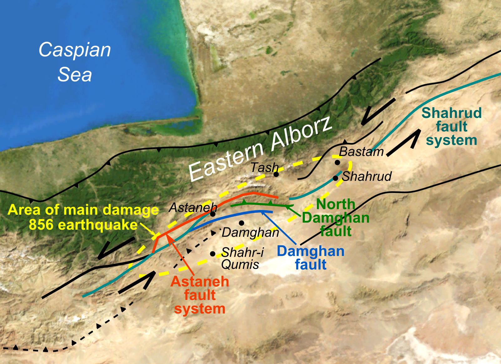
Approximately 1,169 years ago, on 22 December 856 AD, a devastating earthquake struck the city of Damghan and its surrounding areas in the northern region of Qumis in Persia, present day Iran. Contemporary historical accounts and later scholarly records agree that this earthquake ranks among the most destructive natural disasters in human history in terms of both intensity and loss of life. According to historical estimates, the earthquake reached a magnitude of approximately 7.9 on the Richter scale. The death toll is commonly cited at around two hundred thousand people. Although systematic population censuses did not exist in the ninth century, early Islamic and Persian historical sources consistently describe the scale of human loss as extraordinarily high, leaving little doubt about the severity of the catastrophe. At the time, Damghan was an important commercial centre under Abbasid administration and one of the most densely populated cities of ancient Iran. The earthquake caused widespread destruction across the city. Residential quarters, mosques, fortifications, and public buildings collapsed almost entirely, while many nearby settlements disappeared altogether. Historical narratives report that aftershocks continued for several days, deepening fear and instability among the surviving population and compounding the humanitarian crisis. In later centuries, with the emergence of modern historiography and scientific research approximately between 1880 and 1930 AD, scholars undertook systematic efforts to convert dates recorded in the lunar calendar into the Christian calendar using astronomical calculations. Through this process, the date of the Damghan earthquake was established as 22 December 856 AD, a conclusion that is now widely accepted in international academic and scientific records. The Damghan disaster represents more than a natural calamity. It marked a profound turning point in human settlement patterns and construction practices across the region. In the aftermath of the earthquake, greater attention was given to safer locations for habitation. Communities increasingly moved away from unstable mountainous zones toward comparatively secure plains, and the relationship between human settlement and natural risk began to be taken seriously for the first time.
Read More >