
Syed Shayan Real Estate Archive
Syed Shayan Real Estate Archive
From Real Estate History
7 Historical Event found

On September 14, 1901, a private residence in Buffalo, New York, suddenly became part of American history when Vice President Theodore Roosevelt took the oath of office as the 26th President of the United States inside the library of the Ansley Wilcox House. The ceremony took place only hours after President William McKinley died following an assassination attempt. Roosevelt took the presidential oath at approximately 3:32 p.m. The house belonged to prominent Buffalo lawyer Ansley Wilcox and his wife, Mary Grace Wilcox. Wilcox and Roosevelt had been friends for years and shared interests in civil service reform and conservation. Roosevelt stayed at the Wilcox residence during the tense hours following McKinley’s death, and the house was ultimately selected as the location for the unexpected presidential inauguration. The building itself has a much longer history than the dramatic event of 1901. Its earliest section was associated with a military post in Buffalo before the property was converted into a private residence. During the late 19th century, the Wilcox family substantially improved and expanded the property, transforming it into an imposing urban residence. According to the National Park Service, the Wilcoxes redesigned both the interior and exterior of the house and converted two first-floor parlours into a large library. That library was later meticulously restored to its 1901 appearance and remains the central space associated with Roosevelt’s inauguration. The property also demonstrates how a private urban residence can evolve into a nationally significant heritage site. After the Wilcox family period, the building went through several changes and was eventually used as a restaurant. During the 1960s, the historic house faced the possibility of demolition, but preservation efforts helped save the property. The building was restored and became a national historic site in 1970. On September 14, 1971, exactly 70 years after Roosevelt’s inauguration, it opened to the public as a historic site. Today, the Ansley Wilcox House preserves not only the memory of a sudden presidential transition but also an important example of historic-property preservation and adaptive reuse in an American city.
Read More >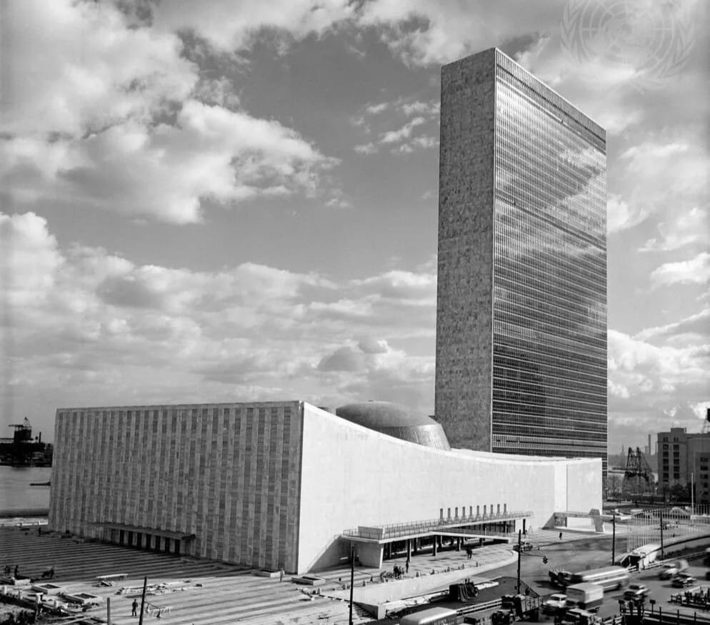
The first offices in the newly built United Nations Secretariat Building in Manhattan were occupied as UN staff began moving from their temporary headquarters at Lake Success, Long Island. The event became significant not only in the history of the United Nations but also in the evolution of modern real estate, urban development and high rise office architecture. The 39-storey Secretariat Building rises about 544 feet above street level. Excavation for the UN Headquarters complex began in September 1948, while erection of the Secretariat Building's steel structure started in April 1949. Within a few years, the tower became one of the most recognisable features of Manhattan's skyline. The real estate story behind the project was equally significant. Before the United Nations established its headquarters there, the East River site was a run down district occupied by slaughterhouses, a railroad garage and other commercial buildings. An $8.5 million contribution from John D. Rockefeller Jr. played a crucial role in securing the site, while New York City later contributed additional property. The Secretariat Building also introduced a striking architectural language to New York. According to the United Nations, it was the city's first skyscraper to feature all glass curtain walls. Its white and green glass exterior stood in sharp contrast to the brick and stone towers that dominated Manhattan at the time. The design helped popularise a style that would later become standard for corporate office towers around the world. The project therefore represented far more than the construction of an international institution. It transformed a former industrial waterfront into one of the world's most important diplomatic addresses and demonstrated how a landmark development could reshape the identity and value of an urban district. August 21, 1950 consequently stands as an important date in real estate history, linking urban regeneration, landmark architecture and the emergence of the modern glass office skyscraper.
Read More >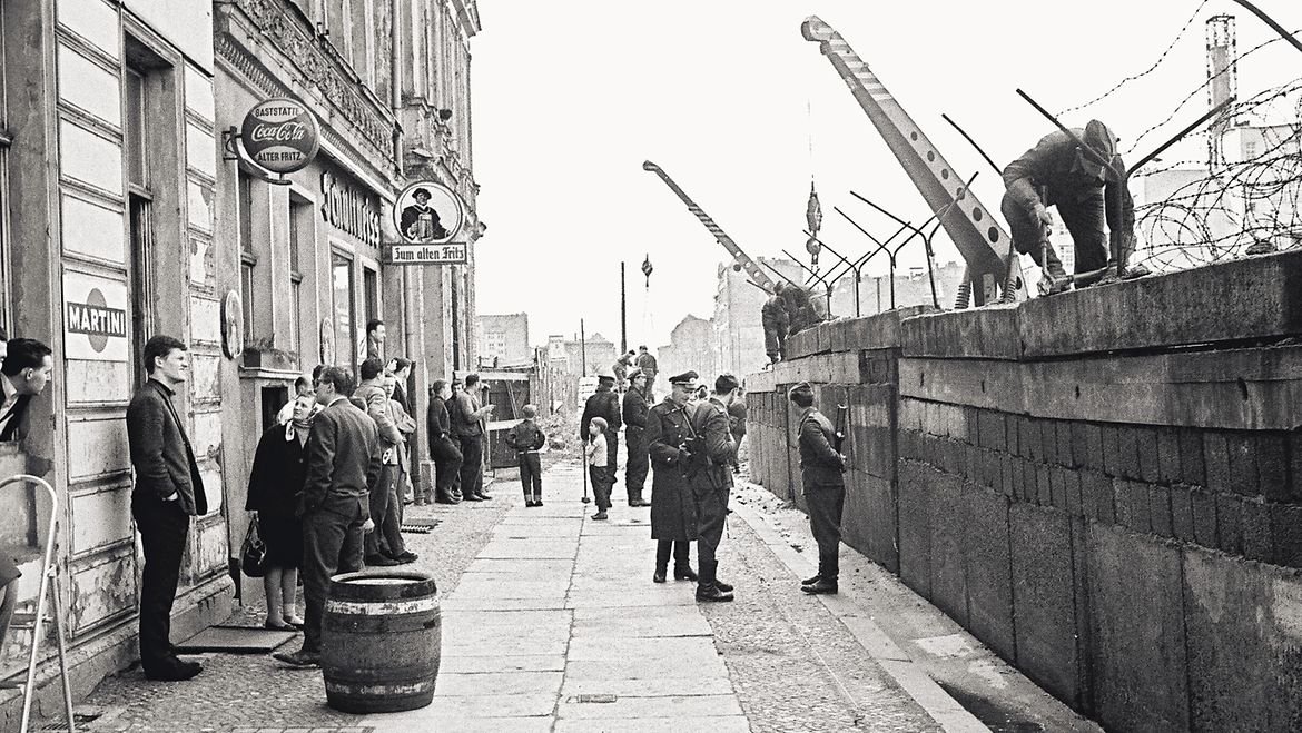
East German authorities began sealing the border between East and West Berlin, an action that would transform not only the political geography of Europe but also the physical structure of one of its most important cities. In the early hours of that Sunday, police, border forces and work crews tore up streets, erected barricades, installed concrete posts and stretched barbed wire across crossing points. Most sector crossings were closed and S Bahn and U Bahn connections between the two sides were interrupted. What began as a sudden barrier of wire and roadblocks was gradually expanded into the Berlin Wall, a 155 kilometre border system that surrounded West Berlin and cut through the city centre. Its impact on urban life was immediate. Streets ended abruptly, public transport routes were severed, neighborhoods were divided and buildings that had once faced ordinary city streets suddenly stood on a major political frontier. Bernauer Strasse became one of the clearest examples. The border ran directly in front of buildings on the East Berlin side, prompting some residents to escape through apartment windows into West Berlin. Within weeks, the buildings were evacuated, residents were forced to move elsewhere and windows and doors facing the border were bricked up. In later years, several buildings were demolished to create a wider and more controlled border strip. For urban and real estate history, August 13 demonstrates how political decisions can instantly alter access to land, housing, streets, transport networks and the relationship between neighborhoods. The Wall remained a defining element of Berlin until November 9, 1989, while systematic dismantling of the border installations began in 1990. August 13, 2026 marks the 65th anniversary of the start of construction, with an official commemoration being held at the Berlin Wall Memorial. The anniversary remains a powerful reminder that cities are shaped not only by architects, developers and property markets; political borders can also redraw the urban landscape and fundamentally change how people use, reach and experience property.
Read More >
Penn Central, one of America’s major railroad companies, declared bankruptcy. Beyond its rail network, the company held extensive interests in land, terminals, hotels and railway-linked commercial properties. Its collapse triggered the restructuring, sale and redevelopment of major transport-related real estate assets across the northeastern United States. Penn Central went bankrupt around two and a half years after the merger of the New York Central Railroad and the Pennsylvania Railroad. At the time, it was the largest corporate bankruptcy in American history. The company operated nearly one-third of the country’s passenger trains and a substantial share of freight rail services in the northeastern United States, meaning its financial crisis also had a severe impact on the regional economy. The bankruptcy was driven by management and business conflicts between the merged companies, redundant rail assets, the movement of industries away from the Rust Belt, and a government condition requiring Penn Central to absorb another already-bankrupt railroad into its system. In 1976, Conrail, a government-established corporation, took control of major assets from Penn Central and other failed railway companies. Unprofitable rail lines and surplus properties were either sold or abandoned, while Conrail later developed into a profitable enterprise.
Read More >
In the aftermath of the First World War, Europe faced widespread devastation. Millions of homes had been destroyed, while soldiers returned from the front to cities unable to absorb them. In Britain, this moment gave rise to the slogan “Homes Fit for Heroes”, encapsulating a growing belief that postwar reconstruction demanded more than physical rebuilding. Within this context, the French government decree issued on 22 December 1924, alongside Britain’s Wheatley Act of the same year, marked a decisive turning point in the history of housing and real estate. For the first time, the provision of housing was formally acknowledged as a public responsibility rather than a charitable or purely private concern. On 22 December 1924, France issued a formal governmental order that transformed the Loucheur Law from a legislative framework into an operational programme. This decree authorised, for the first time, the allocation of public funds specifically for affordable housing, enabled the acquisition and designation of land for residential development, and vested municipal authorities with clear mandates for construction and implementation. Through this administrative and financial framework, the state assumed the role of housing developer, explicitly recognising access to affordable housing as a public right. In the immediate aftermath of the decree, construction commenced under the model of Habitations à Bon Marché (HBM), representing France’s earliest systematic approach to affordable housing. In subsequent years, this framework evolved into the structured system of Habitations à Loyer Modéré (HLM), establishing regulated, low-rent public housing as a permanent feature of the urban landscape. The importance of this moment has endured. Contemporary debates around low-cost housing and social housing policy continue to draw upon the practical foundations laid by the decision of 22 December 1924. Following the issuance of the decree, land acquisition began in the outskirts of Paris for the development of garden cities and collective residential apartment blocks. Designed around principles of open space, natural light, greenery, and access to essential services, these schemes represented a significant departure from prevailing urban models. For the first time, it was formally asserted that low-income citizens were entitled not merely to shelter, but to dignified and adequate living conditions. This decision also established a new precedent for state intervention. While municipal and cooperative housing initiatives had existed on a limited scale prior to this period, it was within this framework that the state, for the first time at a national level, assumed responsibility for large-scale funding, land allocation, and construction. This model later informed social housing policies across Europe and, eventually, across much of the world. Today, as discussions continue in Pakistan and elsewhere regarding low-cost housing, access to housing for lower-income populations, and the role of state subsidy, their intellectual and practical origins can be traced to the decision of 22 December 1924. That moment reframed real estate from a purely investment-driven asset into an arena of social responsibility, positioning housing as a foundational element of the relationship between the state and its citizens.
Read More >
(Berlin) On 3 December 1938, the Nazi government enacted a severe state decree titled “Verordnung über den Einsatz des jüdischen Vermögens” (Regulation on the Use of Jewish Property), through which the forced sale of all residential, commercial and agricultural assets owned by Jewish citizens was formalised in law. Signed by Economics Minister Walther Funk and Interior Minister Wilhelm Frick, the order formed part of Adolf Hitler’s direct policy following Kristallnacht, aimed at removing Jews entirely from Germany’s economic, social and territorial life. Under this decree, Jewish property owners were compelled to sell all their holdings within a fixed period, with only “Aryan” non Jewish Germans permitted as purchasers. As a result, homes, shops and land were transferred at prices far below their actual market value, while a substantial portion of the proceeds was absorbed by the state through taxes and confiscatory measures. Remaining funds were deposited into government-controlled blocked accounts, to which former owners had no free access. A key provision prohibited Jews from acquiring any new real estate, residential rights, mortgages or land. Thus, while they were forced to relinquish their existing property, they were simultaneously denied the right to obtain any alternative accommodation, giving full legal support to the process of Aryanisation. (Aryanisation was the systematic Nazi policy under which Jewish homes, businesses, land, bank accounts and commercial assets were forcibly transferred to non-Jewish German “Aryans”.) This policy became a structured instrument of economic dispossession, depriving thousands of Jewish families of their homes and workplaces and pushing them into ghettos (ghettos being enclosed, prison-like quarters where Jews were segregated from the general population) and forced-labour camps. It represented one of the clearest violations of private property rights and a stark example of state driven expropriation. Following the end of the Second World War, Allied authorities repealed this decree and all anti-Jewish laws in 1945. Post war Germany subsequently enacted restitution and compensation statutes to restore confiscated properties or provide financial redress. Even today, the decree of 3 December 1938 remains a central historical reference point in international discussions on forced expropriation, private property rights and state abuse of authority.
Read More >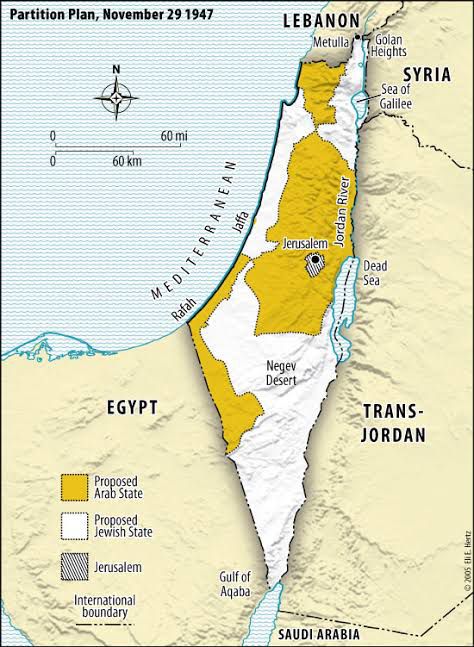
▫This decision is regarded as one of the most consequential developments of its era, shaping the historical geography of land, real estate, urban division, agricultural territory, industrial regions, coastal zones and the boundaries that connected transport routes across the region. ▫The refusal to accept this resolution has shaped the Palestinian experience ever since. On 29 November 1947, during its second session, the United Nations General Assembly adopted Resolution one hundred and eighty one, known internationally as the United Nations Partition Plan for Palestine. Through this resolution, the Assembly recommended the division of British administered Palestine into two separate states, one Jewish and one Arab. The plan also proposed that Jerusalem and Bethlehem be placed under an International Trusteeship in recognition of their religious significance and administrative sensitivity, thereby placing them under international supervision. The resolution received thirty three votes in favour, thirteen against, while ten states abstained. The plan was presented to the General Assembly by the United Nations Special Committee on Palestine, established in May nineteen forty seven. The committee consisted of eleven neutral countries and was mandated to recommend an international solution for the political future of Palestine following the end of the British Mandate. Over several months, the committee conducted extensive field visits, hearings and inquiries across Palestine, and eventually submitted its final report. The report included maps, boundary lines, the proposed division of the territory, and detailed allocations of agricultural land, industrial areas, coastal regions and transport corridors. It is considered one of the most comprehensively documented land division plans of the modern century and represented the first time that the future territorial shape of a region was determined through an international vote. The plan, however, was never implemented. The Arab states and the Palestinian leadership rejected it as unjust, and following the war of nineteen forty eight, Israel took control of far more territory than had been assigned under the resolution. In the years that followed, the nineteen forty nine Green Line, the nineteen sixty seven war, subsequent military occupations, political negotiations and the Oslo process created the borders and administrative arrangements that exist today. These territorial realities do not follow the lines proposed in Resolution one hundred and eighty one. For Palestine, the rejection of the resolution resulted in the loss of the state envisaged for it. The wars of nineteen forty eight and nineteen sixty seven deepened this loss. Almost all land allocated to the Arab state came under Israeli control. The nineteen forty nine Green Line further confined Palestinian territory, while the post nineteen sixty seven arrangements fragmented Gaza, the West Bank and Jerusalem into separate and often disconnected zones. The vision of a unified and sovereign Palestinian state remained limited to documents and maps. In the present moment, after the most prolonged and destructive conflict of recent history, from twenty twenty three to twenty twenty five, both Palestine and Israel stand in a state of devastation. The coastal territory of Gaza has been almost entirely destroyed. It is this shattered landscape that the President of the United States, Donald Trump, has spoken of transforming into a Riviera once the war has ended. (Official records of the United Nations, the General Assembly archives, Encyclopaedia Britannica, BBC Archives and the Al Jazeera Timeline all confirm this event as taking place on twenty nine November nineteen forty seven.)
Read More >