
Syed Shayan Real Estate Archive
Syed Shayan Real Estate Archive
From Real Estate History

On 24 December 1968, the Apollo 8 spacecraft was orbiting the Moon. As it emerged from behind the Moon’s far side, an extraordinary sight appeared before the astronauts. Slowly rising above the Moon’s barren and gray horizon, Earth came into view.
Recognizing the significance of the moment, astronaut William Anders immediately reached for a camera. At the time, the onboard camera was intended primarily for photographing the lunar surface. Acting on instinct, he quickly loaded color film, adjusted the angle, and captured an image of Earth. This photograph was neither planned nor instructed as part of the mission.Yet history was made in that unplanned moment.
The image, later known as Earthrise, became the first photograph of Earth taken from lunar orbit and preserved by a human using a camera. Its historical importance lies in the fact that it marked the first time a human observer captured Earth from space in its entirety.
Before this, images of Earth, including those taken in 1966 by Lunar Orbiter 1, were produced exclusively by automated spacecraft, without any direct human involvement.
The Earthrise photograph profoundly reshaped global thinking about the environment, natural resources, and the protection of the planet. In the United States, its influence was reflected in the adoption of environmentally conscious land-use policies, stricter zoning regulations in urban and suburban areas, and the creation of green belts designed to curb uncontrolled urban expansion and preserve Earth’s natural beauty.
▪️Syed Shayan Real Estate Archive
▪ Reference(s):
24 دسمبر 1968 کو اپالو 8 خلائی جہاز چاند کے مدار میں گردش کر رہا تھا۔ جیسے ہی جہاز چاند کے پچھلے حصے سے نکل کر سامنے آیا، تو خلا بازوں کی آنکھوں کے سامنے ایک غیر متوقع منظر آیا۔ انہیں چاند کے ویران اور سرمئی افق کے اوپر سے زمین آہستہ آہستہ ابھرتی ہوئی نظر آئی۔
یہ منظر دیکھ کر خلا باز ولیم اینڈرز نے فوراً کیمرہ اٹھایا۔ اس وقت جہاز کے اندر موجود کیمرہ بنیادی طور پر چاند کی سطح کی تصویروں کے لیے تھا، مگر انہوں نے جلدی سے رنگین فلم لگائی، زاویہ بدلا اور زمین کی تصویر لے لی۔ نہ یہ تصویر مشن پلان میں شامل تھی اور نہ ہی اس کے لیے کوئی خاص ہدایت دی گئی تھی۔ بس اس لمحے کو یادگار بننا تھا، وہ بن گیا۔
یوں یہ تصویر، جسے ارتھرائز (Earthrise) کا نام دیا گیا، زمین کی پہلی تصویر ہے جسے چاند کے مدار سے خلا میں ایک انسان نے کیمرے کی مدد سے کھینچ کر محفوظ کیا۔
اور اس تصویر کی تاریخی حیثیت یہ ہے کہ یہ خلا سے کھینچی گئی زمین کی پہلی تصویر ہے۔
اس سے پہلے زمین کی جو تصویریں لی گئیں، مثلاً 1966 میں Lunar Orbiter 1 کی تصاویر، وہ بغیر انسان کے، خودکار مشینوں نے لی تھیں۔
خلا سے لی گئی زمین کی اس تصویر نے ماحولیات، قدرتی وسائل اور زمین کے تحفظ کے بارے میں عالمی سوچ کو بدل دیا۔ امریکہ میں اس کا عملی اثر یہ ہوا کہ زمین کے استعمال سے متعلق پالیسیوں میں ماحول دوست اصول شامل کیے گئے، شہروں اور مضافاتی علاقوں میں زوننگ کے قوانین مزید سخت کیے گئے، اور گرین بیلٹس یعنی سبز حفاظتی پٹیاں قائم کی گئیں تاکہ بے ہنگم شہری پھیلاؤ کو روکا جا سکے اور زمین کے قدرتی حسن کو محفوظ رکھا جا سکے۔
▪️ سید شایان ریئل اسٹیٹ آرکائیو

On November 22, 1991, the Punjab Public Health Engineering Department launched a major rural water supply rehabilitation program targeting villages located along major canal systems in districts including Vehari, Lodhran, Jhang, and Muzaffargarh. Throughout the late 1980s and early 1990s, canal-adjacent villages faced declining water quality due to...
Read More →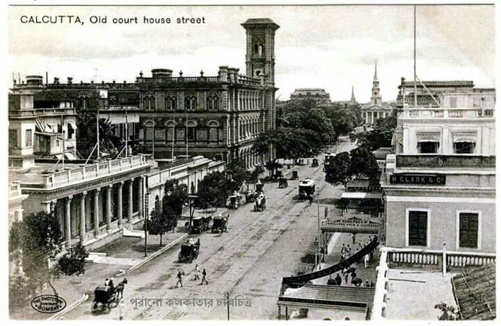
On October 10, 1924, the Registrar of Co-operative Societies in the Bengal Presidency recorded one of the earliest applications for a Residential Cooperative Housing Society in Calcutta, now Kolkata. This marked a turning point in South Asia’s urban development when the cooperative principle, previously used for credit and agriculture, was extend...
Read More →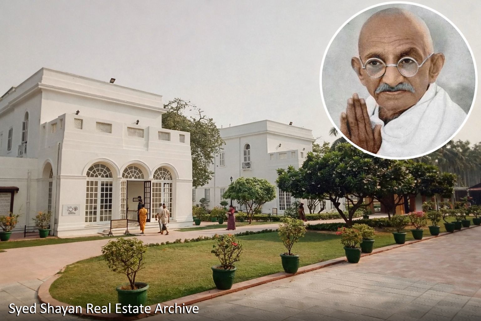
Birla Bhavan is situated within Lutyens’ Delhi, an area regarded as India’s most exclusive, secure, and expensive residential zone. This district is home to foreign diplomatic residences, official homes of central ministers, and several of the country’s most important constitutional institutions. It was on the lawn of Birla Bhavan that Mah...
Read More →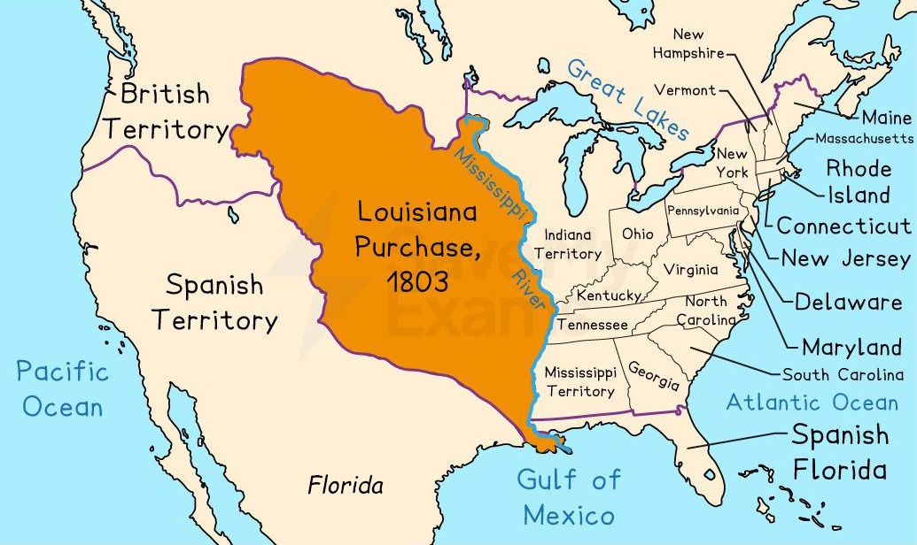
20 December 1803 stands as a defining date in the global history of real estate and land agreements. It not only reshaped the concept of land acquisition but also introduced a new dimension to state expansion, geopolitics, and the strategic value of land. This event is historically known as the Louisiana Purchase. The Louisiana Purchase was not a c...
Read More →
On November 10, 1992, the Capital Development Authority of Pakistan announced a major plan to expand Islamabad toward the southern side of the city. The plan included the creation of two new residential sectors named D12 and E12. The purpose of this expansion was to manage the city’s increasing population and to provide affordable housing options...
Read More →
The acquisition of land for the Model Town Society was one of the most remarkable and spirited chapters in its early history. Dewan Khem Chand and his...
Between 1921 and 1924, the land for Model Town Lahore was acquired in successive phases. The process began in 1921, shortly after the establishment of...
No comments yet. Be the first to comment!