
Syed Shayan Real Estate Archive
Syed Shayan Real Estate Archive
From Real Estate History

On 24 December 1968, the Apollo 8 spacecraft was orbiting the Moon. As it emerged from behind the Moon’s far side, an extraordinary sight appeared before the astronauts. Slowly rising above the Moon’s barren and gray horizon, Earth came into view.
Recognizing the significance of the moment, astronaut William Anders immediately reached for a camera. At the time, the onboard camera was intended primarily for photographing the lunar surface. Acting on instinct, he quickly loaded color film, adjusted the angle, and captured an image of Earth. This photograph was neither planned nor instructed as part of the mission.Yet history was made in that unplanned moment.
The image, later known as Earthrise, became the first photograph of Earth taken from lunar orbit and preserved by a human using a camera. Its historical importance lies in the fact that it marked the first time a human observer captured Earth from space in its entirety.
Before this, images of Earth, including those taken in 1966 by Lunar Orbiter 1, were produced exclusively by automated spacecraft, without any direct human involvement.
The Earthrise photograph profoundly reshaped global thinking about the environment, natural resources, and the protection of the planet. In the United States, its influence was reflected in the adoption of environmentally conscious land-use policies, stricter zoning regulations in urban and suburban areas, and the creation of green belts designed to curb uncontrolled urban expansion and preserve Earth’s natural beauty.
▪️Syed Shayan Real Estate Archive
▪ Reference(s):
24 دسمبر 1968 کو اپالو 8 خلائی جہاز چاند کے مدار میں گردش کر رہا تھا۔ جیسے ہی جہاز چاند کے پچھلے حصے سے نکل کر سامنے آیا، تو خلا بازوں کی آنکھوں کے سامنے ایک غیر متوقع منظر آیا۔ انہیں چاند کے ویران اور سرمئی افق کے اوپر سے زمین آہستہ آہستہ ابھرتی ہوئی نظر آئی۔
یہ منظر دیکھ کر خلا باز ولیم اینڈرز نے فوراً کیمرہ اٹھایا۔ اس وقت جہاز کے اندر موجود کیمرہ بنیادی طور پر چاند کی سطح کی تصویروں کے لیے تھا، مگر انہوں نے جلدی سے رنگین فلم لگائی، زاویہ بدلا اور زمین کی تصویر لے لی۔ نہ یہ تصویر مشن پلان میں شامل تھی اور نہ ہی اس کے لیے کوئی خاص ہدایت دی گئی تھی۔ بس اس لمحے کو یادگار بننا تھا، وہ بن گیا۔
یوں یہ تصویر، جسے ارتھرائز (Earthrise) کا نام دیا گیا، زمین کی پہلی تصویر ہے جسے چاند کے مدار سے خلا میں ایک انسان نے کیمرے کی مدد سے کھینچ کر محفوظ کیا۔
اور اس تصویر کی تاریخی حیثیت یہ ہے کہ یہ خلا سے کھینچی گئی زمین کی پہلی تصویر ہے۔
اس سے پہلے زمین کی جو تصویریں لی گئیں، مثلاً 1966 میں Lunar Orbiter 1 کی تصاویر، وہ بغیر انسان کے، خودکار مشینوں نے لی تھیں۔
خلا سے لی گئی زمین کی اس تصویر نے ماحولیات، قدرتی وسائل اور زمین کے تحفظ کے بارے میں عالمی سوچ کو بدل دیا۔ امریکہ میں اس کا عملی اثر یہ ہوا کہ زمین کے استعمال سے متعلق پالیسیوں میں ماحول دوست اصول شامل کیے گئے، شہروں اور مضافاتی علاقوں میں زوننگ کے قوانین مزید سخت کیے گئے، اور گرین بیلٹس یعنی سبز حفاظتی پٹیاں قائم کی گئیں تاکہ بے ہنگم شہری پھیلاؤ کو روکا جا سکے اور زمین کے قدرتی حسن کو محفوظ رکھا جا سکے۔
▪️ سید شایان ریئل اسٹیٹ آرکائیو

On 27 January 1888, the National Geographic Society was established in Washington DC. The purpose of this institution was to advance understanding of the world’s lands, mountains, rivers, cities, regions, and the human and wildlife populations inhabiting them, and to document this knowledge through systematic mapping. Prior to this, land was gen...
Read More →
On October 26, 2018, blockchain technology began transforming real estate transactions through pilot programs testing property tokenization and smart contracts. This innovation promised to revolutionize property ownership transfers, title management, and transaction recording by creating immutable, transparent digital ledgers. Early adopters explor...
Read More →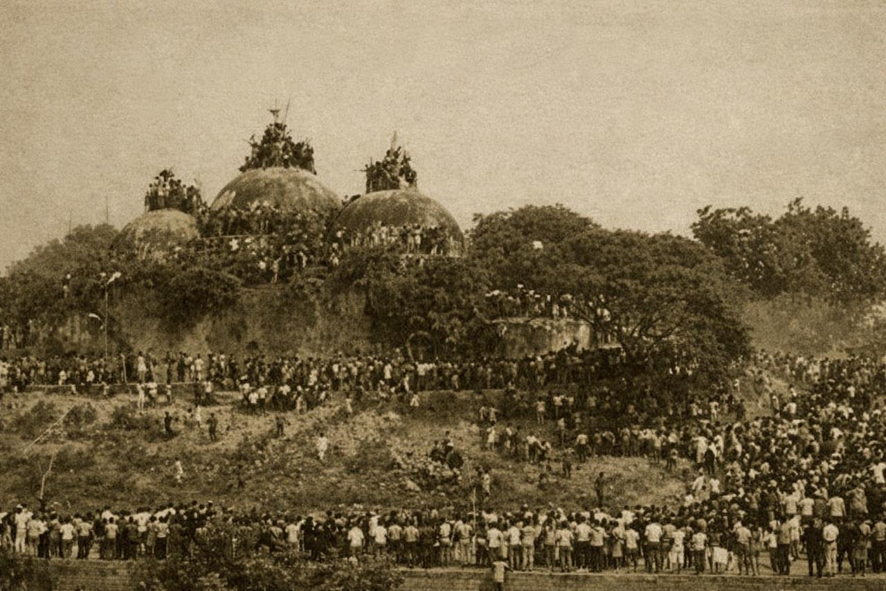
On 6 December 1992, the historic Babri Masjid in the Indian city of Ayodhya was demolished by a large crowd. This event constituted a profound religious trauma for Muslims of the subcontinent and simultaneously became the symbol of a prolonged and complex legal dispute over land and property. Its consequences continue to shape legal reasoning and s...
Read More →
On 26 January 1905, the world’s largest known gem quality diamond, the Cullinan Diamond, was discovered at the Premier Mine in South Africa. The find immediately transformed the economic standing of the mine and its surrounding land, elevating the area to exceptional geological and commercial importance. Weighing 3,106 carats, the Cullinan Diamon...
Read More →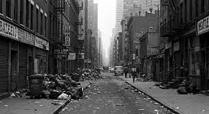
On October 30, 1975, New York City narrowly averted financial catastrophe when President Gerald Ford authorized crucial federal loan guarantees, preventing complete municipal bankruptcy that would have devastated the city's real estate market. The escalating financial crisis had threatened to halt all essential municipal services and construction p...
Read More →
The acquisition of land for the Model Town Society was one of the most remarkable and spirited chapters in its early history. Dewan Khem Chand and his...
Between 1921 and 1924, the land for Model Town Lahore was acquired in successive phases. The process began in 1921, shortly after the establishment of...
No comments yet. Be the first to comment!