
Syed Shayan Real Estate Archive
Syed Shayan Real Estate Archive
From Real Estate History
On This Date
On October 13, 1884, a historic vote at the International Meridian Conference in Washington, D.C., marked a turning point in the development of internationally standardized geographical measurements and mapping systems
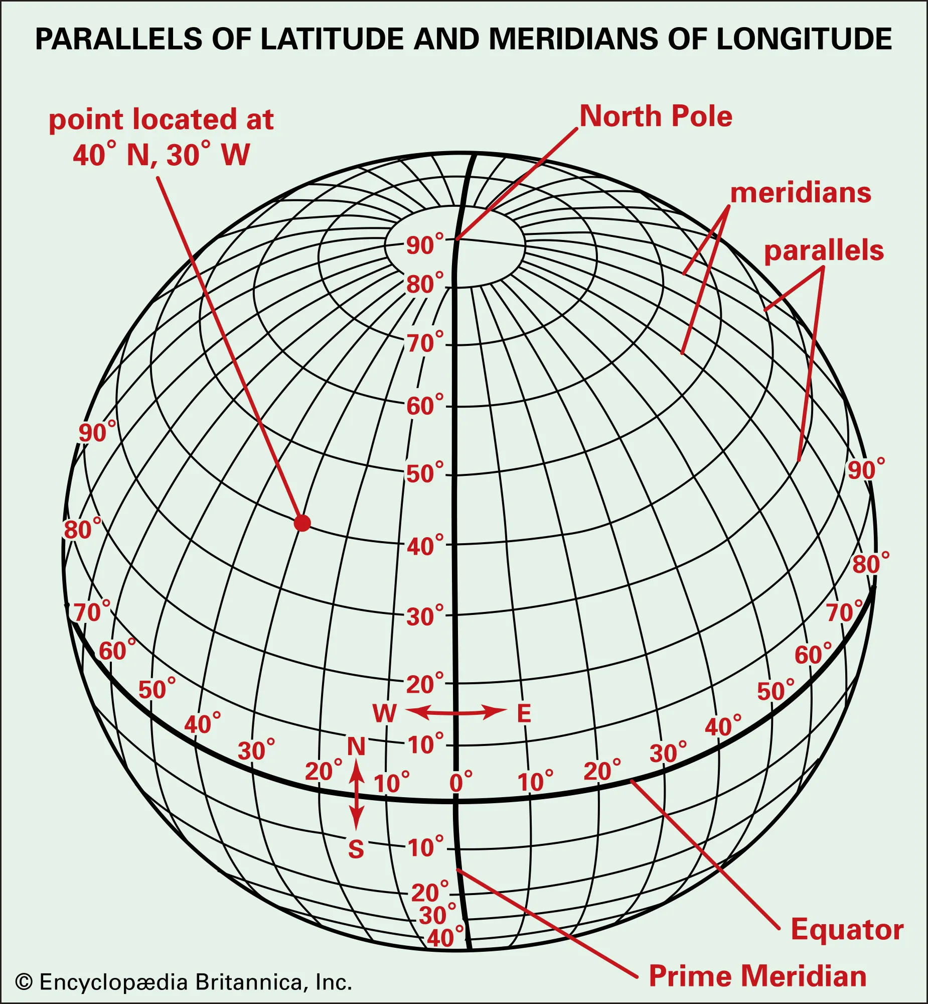
On October 13, 1884, a historic vote at the International Meridian Conference in Washington, D.C., marked a turning point in the development of internationally standardized geographical measurements and mapping systems.
Delegates voted to recommend the meridian passing through the Royal Observatory at Greenwich, England, as the world's common reference for zero degrees longitude, an agreement that would eventually influence geographical mapping, navigation and land surveying across the globe.
During the nineteenth century, different countries used different prime meridians as reference points for their maps and geographical calculations. This lack of standardization created difficulties in international navigation, cartography and the exchange of geographical information.
To address these inconsistencies, the United States government convened the International Meridian Conference in Washington in October 1884. The gathering brought together 41 delegates representing 25 nations to consider a common geographical reference and international timekeeping arrangements.
On October 13, the proposal to adopt Greenwich as the international prime meridian received 22 votes in favour and one against, while representatives of France and Brazil abstained.
The conference formally adopted its final resolutions on October 22, 1884, recommending Greenwich as the starting reference for calculating longitude eastward and westward.
Although the immediate purpose of the conference was to standardize geographical and timekeeping references, its significance extended to fields that would later become central to land administration, surveying and urban development.
From a real estate perspective, accurate geographical referencing is fundamental to establishing the location of land parcels, preparing cadastral maps, planning infrastructure and supporting reliable property information systems.
The principles of geographical standardization advanced by the conference remain relevant to modern technologies, although today's Global Navigation Satellite Systems, Geographic Information Systems (GIS) and digital mapping platforms operate through far more sophisticated geodetic frameworks.
These technologies now assist governments, urban planners and property authorities in identifying land boundaries, developing infrastructure networks, preparing master plans and maintaining digital land records.
For countries such as Pakistan, where rapid urbanization and land administration challenges have increased the importance of accurate mapping, the event offers a valuable historical perspective.
Reliable geographical information can strengthen transparency in land management, improve planning decisions and support more efficient property administration.
The vote of October 13, 1884, remains a landmark in the history of geographical standardization, demonstrating how a shared global reference helped prepare the ground for modern mapping, surveying and spatial planning.
▪️Syed Shayan Real Estate Archive
▪ Reference(s):
On This Date
13 اکتوبر 1884 کو امریکی دارالحکومت واشنگٹن میں منعقدہ بین الاقوامی میریڈیئن کانفرنس میں ایک ایسا تاریخی فیصلہ سامنے آیا جس نے دنیا بھر میں نقشہ سازی اور جغرافیائی مقامات کے تعین کے طریقہ کار پر گہرے اثرات مرتب کیے۔ کانفرنس کے مندوبین نے برطانیہ کے علاقے گرین وچ سے گزرنے والے خطِ طول کو صفر درجے کا مشترکہ عالمی حوالہ بنانے کے حق میں ووٹ دیا۔
13 اکتوبر 1884 کو امریکی دارالحکومت واشنگٹن میں منعقدہ بین الاقوامی میریڈیئن کانفرنس میں ایک ایسا تاریخی فیصلہ سامنے آیا جس نے دنیا بھر میں نقشہ سازی اور جغرافیائی مقامات کے تعین کے طریقہ کار پر گہرے اثرات مرتب کیے۔ کانفرنس کے مندوبین نے برطانیہ کے علاقے گرین وچ سے گزرنے والے خطِ طول کو صفر درجے کا مشترکہ عالمی حوالہ بنانے کے حق میں ووٹ دیا۔
انیسویں صدی کے دوران مختلف ممالک اپنے جغرافیائی نقشوں اور زمینی پیمائش کے لیے الگ الگ ابتدائی خطوطِ طول استعمال کرتے تھے۔ ان مختلف نظاموں کے باعث بین الاقوامی نقشہ سازی، بحری جہاز رانی اور جغرافیائی معلومات کے تبادلے میں مشکلات پیدا ہوتی تھیں۔
اس مسئلے کے حل کے لیے اکتوبر 1884 میں امریکی حکومت کی دعوت پر واشنگٹن میں بین الاقوامی میریڈیئن کانفرنس منعقد ہوئی، جس میں 25 ممالک کے 41 مندوبین شریک ہوئے۔
13 اکتوبر کو ہونے والی ووٹنگ میں 22 مندوبین نے گرین وچ کو عالمی ابتدائی خطِ طول بنانے کی تجویز کی حمایت کی، ایک نے مخالفت کی، جبکہ فرانس اور برازیل کے مندوبین نے رائے شماری میں حصہ نہیں لیا۔ بعدازاں 22 اکتوبر 1884 کو کانفرنس کی قراردادوں کو حتمی شکل دے دی گئی۔
اس فیصلے کے تحت گرین وچ کے تاریخی رصدگاہ سے گزرنے والے خطِ طول کو صفر درجے کا حوالہ بنانے کی سفارش کی گئی، جس سے مشرق اور مغرب کی جانب جغرافیائی طول البلد کے تعین کے لیے مشترکہ بنیاد میسر آئی۔
اگرچہ اس کانفرنس کا بنیادی مقصد بین الاقوامی جغرافیائی اور وقت کے معیارات میں یکسانیت پیدا کرنا تھا، تاہم اس کے اثرات زمین کی پیمائش، سروے اور شہری منصوبہ بندی سمیت متعدد شعبوں تک پھیلے۔
رئیل اسٹیٹ کے تناظر میں اس تاریخی پیش رفت کی اہمیت اس حقیقت میں پوشیدہ ہے کہ کسی بھی زمین یا جائیداد کے درست جغرافیائی محلِ وقوع کے تعین کے لیے قابلِ اعتماد نقشہ سازی بنیادی ضرورت ہے۔
آج جدید جیوگرافک انفارمیشن سسٹمز (GIS)، سیٹلائٹ نیویگیشن، ڈیجیٹل لینڈ ریکارڈز اور شہری منصوبہ بندی میں عالمی جغرافیائی حوالہ جاتی نظام اہم کردار ادا کرتے ہیں۔ اگرچہ موجودہ ٹیکنالوجی کے معیارات 1884 کے فیصلے سے کہیں آگے بڑھ چکے ہیں، لیکن مشترکہ جغرافیائی حوالہ اختیار کرنے کا اصول اسی تاریخی پیش رفت سے مضبوط ہوا۔
پاکستان جیسے ممالک میں، جہاں اراضی کی درست نشاندہی، ڈیجیٹل ریکارڈز اور شہری توسیع اہم انتظامی چیلنج ہیں، یہ واقعہ یاد دلاتا ہے کہ زمین کے شفاف اور مؤثر انتظام کی بنیاد قابلِ اعتماد پیمائش اور یکساں جغرافیائی معلومات پر استوار ہوتی ہے۔
13 اکتوبر 1884 کی تاریخی ووٹنگ نے دنیا کو ایک مشترکہ جغرافیائی حوالہ دینے کی راہ ہموار کی، جو آج بھی جدید نقشہ سازی اور زمین کے انتظامی نظام کی تاریخ کا اہم سنگِ میل ہے۔

On October 18, 2020, the United Arab Emirates (UAE) introduced a set of comprehensive new regulations governing real estate brokerage practices across all seven...
Read More →
UNESCO added the western section of the Roman Empire’s Danube frontier to the World Heritage List. Extending for almost 600 kilometres across Germany, Austria a...
Read More →
On 4 December 2002, the federal government approved the first comprehensive technical review of Islamabad’s 1960 master plan. The cabinet was informed that rap...
Read More →
On 16 September 1939, Moscow witnessed one of the most extraordinary urban engineering operations of the twentieth century when Soviet engineers moved an entire...
Read More →On November 16, 1911 the British East Africa Protectorate (modern day Kenya) issued one of its earliest Township Housing Regulations to address disorderly infor...
Read More →
The acquisition of land for the Model Town Society was one of the most remarkable and spirited chapters in its early history. Dewan Khem Chand and his...

Between 1921 and 1924, the land for Model Town Lahore was acquired in successive phases. The process began in 1921, shortly after the establishment of...
No comments yet. Be the first to comment!