
Home

This article is available in two languages:

What Is Preventing Gilgit Baltistan from Becoming a Constitutional Province?

What Is Preventing Gilgit Baltistan from Becoming a Constitutional Province?

Gilgit Baltistan and Pakistan’s Constitutional Framework: Why Has Provincial Status Remained Unresolved?
🔳 If present day realities are taken into account, Gilgit Baltistan today arguably holds greater strategic importance for Pakistan than Kashmir itself. Pakistan’s land connection with China, the China Pakistan Economic Corridor, billions of dollars in investment, the Diamer Bhasha Dam, and important defence routes are all located in this region. For this reason, continuing to keep Gilgit Baltistan under an unclear federal status rather than granting it formal constitutional provincial status requires serious reconsideration.
▫️ Was linking Gilgit Baltistan with the Kashmir dispute a historical mistake?
▫️ There is considerable debate about creating new provinces in Pakistan, but why is there silence when it comes to making Gilgit Baltistan a province?
▫️ Why has Pakistan still not been able to make Gilgit Baltistan a formal constitutional province? What constitutional, diplomatic, or political obstacles have delayed such a decision for decades?
Subject: Does Pakistan Need New Provinces? | Episode 7
What Is Preventing Gilgit Baltistan from Becoming a Constitutional Province?
🔺 The constitutional status of Gilgit Baltistan is a sensitive national issue. In light of the resolution adopted by its present Legislative Assembly, immediate progress should therefore be made towards granting the region the status of an interim constitutional province.
Written and Researched by Syed Shayan
Gilgit Baltistan is not currently a formal constitutional province of Pakistan. It is a separate territory administered by the federation and is generally regarded as a federally administered Administrative Unit. Spread over 72,496 square kilometres of difficult mountainous terrain, it had a population of approximately 1.71 million according to the 2023 Census, with an average population density of about 24 persons per square kilometre.
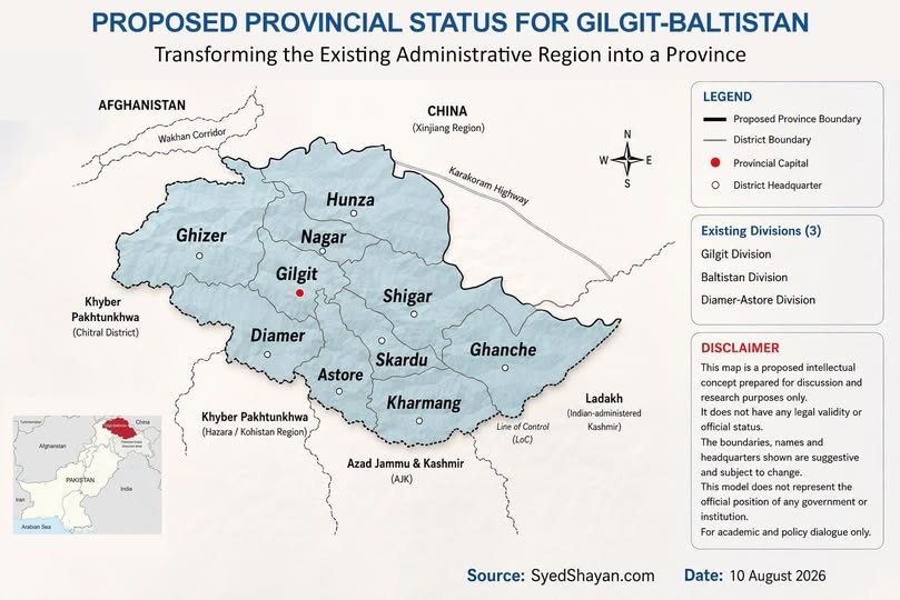
Under the present administrative structure, Gilgit Baltistan consists of 3 divisions, Gilgit, Baltistan and Diamer, and 10 established districts. Gilgit Division comprises Gilgit, Ghizer, Hunza and Nagar. Baltistan Division comprises Skardu, Shigar, Ghanche and Kharmang. Diamer Division comprises Diamer and Astore.
Basic Statistics of Gilgit Baltistan
Total Area: 72,496 square kilometres
Population 2023: 1,709,049, approximately 1.709 million
Divisions: 3
Districts: 10
Tehsils: 34
Average Population Density: approximately 24 persons per square kilometre
1. Gilgit Division
Gilgit District
Area: 4,208 square kilometres
Population: 324,552
Tehsils: Gilgit, Danyor, Jaglot
Ghizer District
Area: 12,381 square kilometres
Population: 200,069
Tehsils: Punial, Ishkoman, Gupis, Yasin, Phander
In the official 2026 EMIS records, Gupis and Yasin continue to be shown as part of Ghizer District.
Hunza District
Area: 10,109 square kilometres
Population: 65,497
Tehsils: Aliabad, Gojal, Shinaki
Nagar District
Area: 4,137 square kilometres
Population: 87,410
Tehsils: Nagar I, Sikandarabad Nagar II, Chalt
2. Baltistan Division
Skardu District
Area: 10,168 square kilometres
Population: 278,885
Tehsils: Skardu, Gamba, Roundu, Gultari
Shigar District
Area: 4,173 square kilometres
Population: 84,608
Tehsils: Shigar, Gulabpur
Kharmang District
Area: 6,144 square kilometres
Population: 61,304
Tehsil: Kharmang
Ghanche District
Area: 8,531 square kilometres
Population: 157,822
Tehsils: Khaplu, Mashabrum, Daghoni, Chorbat, Keris, Ghawari
In the current official EMIS records, Ghawari is listed as a separate tehsil, while Haldi falls under Mashabrum Tehsil.
3. Diamer Division
Diamer District
Area: 7,234 square kilometres
Population: 337,329
Tehsils: Chilas, Darel, Tangir, Babusar, Goharabad
In the official 2026 records, Darel and Tangir continue to be shown as part of Diamer District.
Astore District
Area: 5,411 square kilometres
Population: 111,573
Tehsils: Astore, Shounter
A review of the above details concerning divisions, districts and tehsils shows that Gilgit Baltistan already has an established governmental structure. The central question is therefore simple: when will it be granted constitutional provincial status?
For several decades, the people of Gilgit Baltistan have consistently demanded that the region be recognised as a constitutional province of Pakistan so that its citizens can obtain full and formal representation in the National Assembly, the Senate and other constitutional institutions, including the NFC and CCI.
The strongest formal basis for this public and political demand is the unanimous resolution adopted by the Gilgit Baltistan Legislative Assembly on 11 August 2015. The resolution called upon the federation to declare Gilgit Baltistan an interim constitutional province, or Provisional Province, until the final international settlement of the Kashmir dispute, so that the region’s citizens could receive all basic constitutional rights without prejudicing Pakistan’s international position.
This resolution was not merely symbolic. It explicitly stated that the people of Gilgit Baltistan had liberated the region from Dogra rule in 1947 and 1948 and had acceded to Pakistan without conditions. Since then, the people of the region have used Pakistani passports and have remained part of the administrative system of the State of Pakistan, yet constitutionally they still remain outside the formal federal structure.
The demand continued after 2015. In March 2021, the Gilgit Baltistan Assembly once again unanimously adopted a resolution seeking interim provincial status.
In July 2026, the Assembly again unanimously reiterated the same position and called for implementation of the recommendations of the Sartaj Aziz Committee. That committee had also recommended interim provincial status so that Pakistan’s international position on Kashmir could remain protected until a final settlement.
The people of the region have also demanded constitutional rights and full national representation for many years. The question of making Gilgit Baltistan a formal Constitutional Province of Pakistan should therefore no longer be indefinitely postponed. It should now be taken seriously towards a final decision.
The question, then, is this: why does Pakistan not make Gilgit Baltistan a legal province?
Pakistan has refrained from granting Gilgit Baltistan permanent constitutional provincial status primarily because of its connection with the Kashmir dispute. The official position is that if Article 1 of the Constitution were amended to incorporate the region as a permanent province, it could create the international impression that Pakistan had permanently integrated the territory. This could, in turn, weaken Pakistan’s position on the right of self determination under United Nations resolutions concerning Kashmir.
For this reason, the Sartaj Aziz Committee recommended interim constitutional provincial status in 2015. Later, in 2020, Imran Khan also announced that Gilgit Baltistan would be granted interim provincial status, but the required constitutional amendment was never completed. The same formula remains under discussion so that the region’s citizens can receive representation and constitutional rights while Pakistan’s international position remains protected.
If Gilgit Baltistan is granted interim constitutional provincial status, its existing 3 divisions, Gilgit, Baltistan and Diamer, appear sufficient and reasonably balanced for the present. There is no strong and sustained demand for the creation of a fourth or fifth division. It may therefore be preferable to begin with the existing administrative boundaries. Gilgit could remain the provincial capital, while a permanent second secretariat or seasonal sessions of the Assembly could be established in Skardu so that the people of Baltistan also have greater administrative access.
As a student of history and politics, I often ask myself whether linking Gilgit Baltistan with the Kashmir dispute was a historical mistake on the part of Pakistan’s former rulers.
My own view is that making Gilgit Baltistan’s constitutional status conditional upon the Kashmir dispute proved to be a political decision that left the people of this region constitutionally suspended for decades. Looking further back into history, the region has a distinct political, geographical and cultural identity that extends over many centuries.
Historical records from the 7th and 8th centuries contain references to Great Bolor for Baltistan and Little Bolor for the Gilgit region. The distinguished historian Dr Ahmad Hasan Dani, in his book History of Northern Areas of Pakistan, also discusses the region’s distinct historical identity and makes clear that the whole of present day Gilgit Baltistan did not have one continuous and permanent historical constitutional relationship with Kashmir.
In the 19th century, the Dogra rulers established control over different parts of Gilgit and Baltistan through military force. However, a few decades of Dogra rule cannot reasonably be treated as a substitute for the region’s separate historical identity extending over centuries. In 1947, a revolt against Dogra rule took place in Gilgit, and independence was declared on 1 November, after which the local leadership chose the path of association with Pakistan.
Nevertheless, Gilgit Baltistan had no direct representation in the Karachi Agreement of 1949. Its administrative affairs were handed over to the Government of Pakistan, while its constitutional status remained linked with the Kashmir dispute. In my view, this reflected both insufficient attention to history and a lack of political foresight on the part of earlier policymakers. Had the region’s long and distinct history been fully considered at the time, Gilgit Baltistan might not have been linked to the Kashmir dispute in the manner that it was.
The consequence of that decision is that even today Gilgit Baltistan does not enjoy the status of a full province under the Constitution of Pakistan. It does not have provincial level constitutional representation in the National Assembly and Senate, and its position within important federal constitutional institutions, including the NFC, remains unclear.
India’s actions in 2019 changed the political context of the region when it removed the special constitutional status of Jammu and Kashmir under its administration and incorporated it into its federal system. Following that development, a view also emerged within Pakistan that, as a corresponding measure and without prejudicing Pakistan’s position at the United Nations, Gilgit Baltistan could be granted interim provincial status so that its people could obtain constitutional rights and the problem of its incomplete administrative status could be addressed.
The question is: how long is Gilgit Baltistan to remain under its present Administrative Status?
Gilgit Baltistan is not an ordinary region.
It contains some of the world’s highest mountains, including K2, the great Karakoram and Himalayan ranges, vast glaciers, the Karakoram Highway, Pakistan’s land connection with China, and national assets such as the Diamer Bhasha Dam. The region is therefore of exceptional importance not only because of its natural wealth, but also for Pakistan’s water resources, energy, tourism and national security.
A brief examination of its economic and mineral potential shows that Gilgit Baltistan contains valuable gemstones, including rubies, emeralds and topaz, as well as important industrial and rare minerals such as copper, gold and Rare Earth Elements.
Its tourism economy alone attracts hundreds of thousands of domestic and international tourists every year, generating billions of rupees in economic activity within the region. If Gilgit Baltistan were granted a formal fiscal share under the NFC Award, together with clear provincial laws governing local minerals and tourism, the region could potentially become financially self sufficient rather than remaining dependent on the federation and could contribute billions of rupees to the national economy.
The question therefore arises: is it appropriate for a region of such extraordinary geographical, economic and strategic significance to remain merely an Administrative Unit under federal administration?
The time has come to review this historical issue afresh and grant Gilgit Baltistan the status of an interim constitutional province, thereby giving it a clearly defined place within Pakistan’s constitutional system, parliamentary representation and full constitutional rights.
Pakistan now needs a clear and serious national decision on the constitutional status of Gilgit Baltistan.
(To be continued in the next instalment)
3
0
Views
20
1

Previous Articles

How Many Provinces Could Be Created in Balochistan?

Balochistan: When the Provincial Capital Is 900 Kilometres Away If a resident of Balochistan has to travel from a distant area such as Gwadar, Turbat or Khuzdar to Quetta for official work, the journey may cover as much as 900 kilometres one way. A return trip can therefore extend to approximately 1,800 kilometres, with two or three days consumed largely by travel. The question is simple: should a provincial capital be this far from its citizens? Subject: Does Pakistan Need New Provinces? | Episode 6 How Many Provinces Could Be Created in Balochistan? 🔺 Pakistan’s problem is not simply the number of provinces. It is also the growing distance between government and the people. A central conclusion of my research is that provinces should not be so large that, for an ordinary citizen, reaching the provincial capital feels like entering an entirely different world. Written and Researched by Syed Shayan The demand for new provinces in Balochistan is not new. In the past, proposals have been made for a separate province for Pashtun majority areas, while in more recent years the idea of creating a separate province in southern Balochistan has also emerged. The model presented in this article, however, proposes six provinces across Balochistan. It is a new administrative concept developed by our think tank after considering historical demands, geography, population, distances and economic potential. Following a notification issued by the Revenue Department of the Government of Balochistan on 8 July 2026, the province now consists of 11 divisions and 41 districts. Quetta has been divided into East Quetta and West Quetta, Mastung has been included in Quetta Division, and four new divisions, Pishin, Khuzdar, Lasbela and Koh e Suleman, have been created. The new structure is as follows. 1. Quetta Division: 3 Districts East Quetta, West Quetta, Mastung 2. Pishin Division: 4 Districts Pishin, Killa Abdullah, Chaman, Barshore 3. Khuzdar Division: 4 Districts Khuzdar, Kalat, Surab, Wadh 4. Lasbela Division: 3 Districts Lasbela, Hub, Awaran 5. Rakhshan Division: 4 Districts Chagai, Kharan, Nushki, Washuk 6. Makran Division: 4 Districts Kech, Gwadar, Panjgur, Tump 7. Naseerabad Division: 5 Districts Naseerabad, Jaffarabad, Jhal Magsi, Sohbatpur, Usta Muhammad 8. Sevi Division, formerly Sibi: 3 Districts Sevi, Kachhi, South Dera Bugti 9. Zhob Division: 3 Districts Zhob, Killa Saifullah, Sherani 10. Loralai Division: 5 Districts Loralai, Duki, Musakhail, Ziarat, Harnai 11. Koh e Suleman Division: 3 Districts Kohlu, Barkhan, North Dera Bugti Total: 11 divisions and 41 districts. Under this new arrangement, Quetta has been divided into two districts, the former Kalat Division has been replaced by Khuzdar and Lasbela Divisions, and several new districts have been created with newly defined boundaries. 🔘 Balochistan is Pakistan’s largest province by area, covering 347,190 square kilometres. According to the 2023 Census, its population is 14,894,402. In terms of population density, Balochistan differs dramatically from the other provinces. It has only about 43 people per square kilometre, compared with approximately 622 in Punjab, 402 in Khyber Pakhtunkhwa and 395 in Sindh. This contrast makes it clear that Balochistan’s administrative challenges cannot be assessed on population alone. Its vast area, long distances and dispersed population must also be taken into account. How far does a citizen living in a remote part of Balochistan have to travel if provincial level official work requires a visit to Quetta? For example, the road distance from Gwadar to Quetta is approximately 900 kilometres, and the journey can take between 12 and 14 hours. Turbat is around 750 kilometres from Quetta, while Zhob is approximately 330 kilometres away. For residents of some parts of the province, therefore, reaching their own provincial capital can require almost a full day of travel. In large and sparsely populated regions around the world, the solution is not to force citizens to travel to government. The objective is to bring government closer to citizens. The United States, Australia, India and China have each developed different systems for devolving authority and administrative services closer to local populations. Australia even measures how far communities are located from essential services. The same principle raises a fundamental question for Balochistan: how far should government be from the people? This is where the question of Balochistan’s administrative restructuring begins. If the objective is to bring government closer to citizens, will the creation of new districts alone be sufficient, or does a province of this size also require additional provincial centres? And if new provinces are to be created, how many should there be, where should their boundaries lie, and where should their capitals be located? The answer cannot be found through population figures alone. Area, distance, travel time, economic resources, and regional and cultural realities must all be considered. Before considering a new administrative structure for Balochistan, it is also necessary to understand its linguistic and cultural composition. The 2023 Census records mother tongue rather than ethnicity. According to the census, Balochi, Pashto and Brahui speakers constitute the major linguistic groups in the province, while Sindhi, Saraiki, Urdu and other languages are also spoken. Balochi speaking populations are concentrated primarily in Makran, Rakhshan and southwestern Balochistan. Pashto speaking populations are more prominent in Quetta, Pishin, Chaman, Zhob, Killa Saifullah and northern areas, while Brahui speaking populations are more concentrated in Kalat, Khuzdar, Mastung and central Balochistan. In many areas, however, these communities are also intermixed. For this reason, we believe that new provinces cannot be designed solely on the basis of area and distance. Linguistic sensitivity, regional identity and social cohesion must also be considered so that administrative reform does not create a new sense of deprivation or separation among any major community. With these considerations in mind, we examined Balochistan’s regions, existing divisions, demographic linkages, distances, employment opportunities and sources of income, and developed the following model of six proposed provinces. The objective is to make government more accessible while avoiding unnecessary division of regions or communities. 1. Proposed Province of Makran Existing Division: Makran Division Districts: Gwadar, Kech, Panjgur, Tump Proposed Capital: Turbat Population 2023: approximately 1.876 million Area: 52,067 square kilometres Population Density: approximately 36 persons per square kilometre Languages and Culture: Balochi speaking communities are predominant in this region, although other local languages and dialects are also spoken in different areas. Makran is one of Balochistan’s most distinctive regions in terms of Balochi language, culture, coastal traditions and historical regional identity. Prominent Tribes and Communities: Gichki, Buledi, Bizenjo, Dashti, Hot, Rind and other local Baloch tribes and communities. Rationale for the Proposed Province: Makran forms a naturally connected coastal and southwestern region whose districts already share historical, linguistic, cultural and economic links. Gwadar, because of its port, coastal economy and international commercial importance, could become the principal economic centre of the proposed province, while Kech, Panjgur and Tump are important for agriculture, border trade and the local economy. Turbat has been proposed as the capital instead of Gwadar primarily because of administrative accessibility and geographical balance. Gwadar is the region’s most important port, economic and commercial centre, but Turbat occupies a relatively more central location within Makran and offers more balanced access between Panjgur, Kech, Tump and Gwadar. This would allow Gwadar to function as the economic centre while Turbat serves as the administrative capital. Note: Tump was part of Kech District at the time of the 2023 Census and became a separate district later. For this reason, the total population and area calculations for 2023 include the complete figures of the former Kech District. 2. Proposed Province of Rakhshan Existing Division: Rakhshan Division Districts: Chagai, Nushki, Kharan, Washuk Proposed Capital: Kharan Population 2023: approximately 1.040 million Area: 98,596 square kilometres Population Density: approximately 11 persons per square kilometre Languages and Culture: Balochi speaking populations are predominant in this region, while Brahui and other languages are also spoken. Prominent Tribes and Communities: Rakhshani, Nausherwani, Sanjrani, Muhammad Hasni, Badini, Jamaldini, Reki and other local Baloch and Brahui tribes and communities. Rationale for the Proposed Province: Rakhshan is one of Balochistan’s largest and most sparsely populated regions. Chagai’s mineral resources, proximity to the Iranian and Afghan borders, Nushki’s role as a transport connection, and the vast geography of Kharan and Washuk provide a strong basis for considering it as a separate provincial unit. Kharan has been proposed as the capital because of its relatively central location, which could provide more balanced administrative access across this extensive region. 3. Proposed Province of Khuzdar Existing Divisions: Khuzdar Division and Lasbela Division Districts: Khuzdar, Kalat, Surab, Wadh, Lasbela, Hub, Awaran Proposed Capital: Khuzdar Population 2023: approximately 2.408 million Area: 88,459 square kilometres Population Density: approximately 27 persons per square kilometre Languages and Culture: Brahui and Balochi speaking populations are prominent in this region, while Lasi, Sindhi and other languages are also spoken in Lasbela and Hub. Prominent Tribes and Communities: Mengal, Zehri, Bizenjo, Muhammad Hasni, Sumalani, Sajidi, Jamot, Lasi and other Baloch, Brahui and local tribes and communities. Rationale for the Proposed Province: Khuzdar is an important administrative, educational and commercial centre of central Balochistan. The historical and geographical connections among Khuzdar, Kalat, Surab and Wadh, combined with the inclusion of Lasbela, Hub and Awaran, would create a relatively integrated provincial unit. Hub and Lasbela connect the region with Karachi’s industrial, commercial and coastal economy, while Khuzdar’s relatively central location and existing urban and administrative capacity make it an appropriate choice for the proposed capital. Note: Wadh was part of Khuzdar District at the time of the 2023 Census and was made a separate district in 2026. Its territory and population are therefore already included in the 2023 figures for Khuzdar District. 4. Proposed Province of Quetta Existing Divisions: Quetta Division and Pishin Division Districts: East Quetta, West Quetta, Mastung, Pishin, Barshore, Killa Abdullah, Chaman Proposed Capital: Quetta Population 2023: approximately 4.572 million Area: 17,867 square kilometres Population Density: approximately 256 persons per square kilometre Languages and Culture: Pashto speaking communities are prominent in this region, while Quetta itself is a multilingual and multicultural urban centre inhabited by Pashtun, Baloch, Brahui, Hazara, Urdu speaking and other communities. Prominent Tribes and Communities: Achakzai, Tareen, Kakar, Kasi and other Pashtun tribes and communities. Baloch, Brahui, Hazara and other local and urban communities are also present in Quetta and Mastung. Rationale for the Proposed Province: Keeping the complete Quetta and Pishin Divisions within one provincial unit would preserve the geographical and administrative continuity of northwestern Balochistan without dividing any existing division. Quetta is already the largest administrative, educational, medical and commercial centre of this region and possesses the principal infrastructure required at the provincial level. Retaining it as the proposed capital is therefore the most appropriate option. Note: East Quetta, West Quetta and Barshore assumed their current administrative form after the 2023 Census. The 2023 figures have therefore been compiled by aligning the geography of the former districts with the present boundaries. 5. Proposed Province of Sevi Naseerabad Existing Divisions: Sevi Division, Naseerabad Division and Koh e Suleman Division Districts: Sevi, Kachhi, South Dera Bugti, Naseerabad, Jaffarabad, Jhal Magsi, Sohbatpur, Usta Muhammad, Kohlu, Barkhan, North Dera Bugti Proposed Capital: Sevi Population 2023: approximately 3.094 million Area: 43,534 square kilometres Population Density: approximately 71 persons per square kilometre Languages and Culture: The region includes Baloch, Brahui, Sindhi, Saraiki and other local populations. Baloch tribal communities are prominent in Kohlu and Dera Bugti, while Khetran and other local communities are present in Barkhan. Sindhi and Saraiki linguistic and cultural influences are particularly visible in the plains of Naseerabad, Jaffarabad, Sohbatpur and Usta Muhammad. Prominent Tribes and Communities: Marri, Bugti, Khetran, Magsi, Jamali, Domki, Umrani, Rind, Khosa and other Baloch and local tribes and communities. Rationale for the Proposed Province: This could form a large but geographically connected provincial unit covering eastern and southeastern Balochistan. Naseerabad and Jaffarabad are important centres of agricultural production. Dera Bugti is significant for natural gas and mineral resources, while Kohlu and Barkhan are important for livestock and other natural resources. Sevi occupies a relatively balanced location between the mountainous and plains regions of Balochistan and serves as a natural point of connection between them. It is therefore proposed as the provincial capital. Under this arrangement, all three existing divisions would remain intact and no district or division would need to be divided. Note: North Dera Bugti and South Dera Bugti assumed their present administrative form as separate districts after the 2023 Census. The combined 2023 population and area figures therefore include the complete geography of the former Dera Bugti District. 6. Proposed Province of Zhob Loralai Existing Divisions: Zhob Division and Loralai Division Districts: Zhob, Killa Saifullah, Sherani, Loralai, Duki, Musakhail, Ziarat, Harnai Proposed Capital: Loralai Population 2023: approximately 1.904 million Area: 46,667 square kilometres Population Density: approximately 41 persons per square kilometre Languages and Culture: Pashto speaking populations are predominant in this region, while individual districts also contain local linguistic, cultural and tribal diversity. Prominent Tribes and Communities: Kakar, Mandokhel, Sherani, Musakhail, Luni, Nasar and other Pashtun and local tribes and communities. Rationale for the Proposed Province: A look at the map shows that the Zhob and Loralai regions are naturally connected. Their populations share broadly similar patterns of life and environment. One of the most important advantages of creating this province would be that residents of distant districts such as Zhob, Sherani, Killa Saifullah and Musakhail would no longer need to undertake long and exhausting journeys to Quetta for relatively routine government work. Loralai has been proposed as the capital because it lies in a comparatively central position among these districts. It provides relatively convenient access from across the proposed province and would allow residents of different areas to reach the provincial centre more easily. This arrangement would also keep the region’s Pashtun population within a broadly connected social and cultural administrative unit. An important advantage is that the proposal does not divide any existing district or area within the present Zhob and Loralai Divisions. The two divisions would simply be combined in their existing form to constitute a new province. 🔘 Readers, In developing these six proposed provinces, the principal criteria have been area, population, travel accessibility, the existing administrative structure, economic autonomy, urban capacity and geographical connectivity. Although language, culture and the tribal and sardari systems have not been used as the basis of the proposed division, they have been recognised as important social realities. The objective is to avoid unnecessarily dividing historically connected communities in a manner that could create new disputes. Accordingly, historical and administrative continuity has been preserved wherever possible. The districts of Makran have been kept together. Rakhshan has been retained in its existing administrative form. The historical continuity of Kalat has been preserved as far as possible. In restructuring Quetta and northeastern Balochistan, particular attention has been given to geographical continuity, distance, economic linkages and the administrative capacity of central cities. The discussion of the tribal system in this article is not intended to endorse a tribal approach. It is included because the history, geography and social realities of Balochistan cannot simply be ignored. Administrative reform that disregards these realities is unlikely to succeed. This is neither a final judgement nor a definitive map. The proposed boundaries can be improved through local consultation and further research. The central and sole objective of this entire exercise is the establishment of better governance. The History of Demands for New Provinces in Balochistan The idea of creating new provinces in Balochistan is not new. When Pakistan was created in 1947, the territory now known as Balochistan did not exist in its present form. The area administered by the British had a separate status, while the states of Kalat, Makran, Lasbela and Kharan also had their own distinct status. Following several political developments, and after the abolition of the One Unit system in 1970, Balochistan acquired the provincial form that exists today. The present province of Balochistan is therefore itself the product of an earlier administrative restructuring. Since 1970, demands for a separate administrative identity for the Pashtun areas of northern Balochistan have repeatedly emerged. This demand was initially raised by Khan Abdul Samad Khan Achakzai and was later carried forward by the Pashtunkhwa Milli Awami Party. December 2006: Mahmood Khan Achakzai proposed the creation of a separate administrative unit for Pashtun areas and suggested names including Pakhtunkhwa, Pashtunistan and Afghania. October 2010: Dr Mir Haji Tareen, head of the Balochistan Pashtun Movement, called for a separate province comprising Pashto speaking areas and argued that the region could finance its own expenditure from its own resources. 2016: On the anniversary of Khan Abdul Samad Khan Achakzai, Mahmood Khan Achakzai again presented the idea of an Afghania Province for the Pashtun population. Historically, therefore, the most persistent and longstanding demand for administrative restructuring within Balochistan has concerned a separate province or administrative unit for the northern Pashtun areas. Southern Balochistan and the Government’s Own Experience Another dimension of the debate concerns southern Balochistan. In 2020, the federal government announced a special development initiative for districts including Washuk, Kharan, Panjgur, Kech, Lasbela, Awaran, Khuzdar and Gwadar. Prime Minister Imran Khan travelled to Turbat to inaugurate the development package. Although this was not an announcement of a new province, it did demonstrate that the government itself recognised southern Balochistan as a region with distinct development challenges and needs. Then, in July 2026, the Government of Balochistan itself undertook a major administrative restructuring. Quetta was divided into two districts, East Quetta and West Quetta, while new districts and divisions were created. As a result, the total number of divisions increased to 11 and districts to 41. Balochistan covers approximately 44 percent of Pakistan’s total land area. Gwadar, Reko Diq, gold and copper deposits, and maritime trade could transform the region into a major economic centre in the coming decades. For this reason, decisions concerning Balochistan’s administrative system should not be based solely on present conditions. They should be made with the needs of the next 50 or 100 years and future generations in mind. (To be continued in the next instalment)
Does Pakistan Really Need New Provinces?

The Debate on New Provinces in Pakistan Is a Valid Question Raised at the Wrong Time 🔳 The debate on creating new provinces in Pakistan is undoubtedly a valid issue, but it has been raised at the wrong time. Various international studies have shown that when new provinces or administrative units are created, people become less dependent on major cities for healthcare, employment and judicial matters, allowing economic activity to spread more widely across the country. ▫️ People in Pakistan need to understand that a province is not a separate state. It is an administrative unit through which the state governs. ▫️ Administrative division should not be confused with political division. Just as a large institution, bank or company creates different zones or branches in order to operate more efficiently, provinces are also a means of improving governance. ▫️ People strongly prefer that the taxes they pay should be spent in their own regions. The smaller and more accessible a province is, the easier it becomes to monitor the misuse of funds and corruption. ▫️ When administrative units are smaller and empowered, the burden on central and provincial governments is reduced and the federation becomes stronger because citizens are less dependent on the centre or a distant provincial capital for the protection of their rights. ▫️ In countries with ethnic, linguistic or geographical diversity, the creation of new provinces or the granting of regional autonomy has, in several cases, led to a noticeable reduction in rebellion against central authority and in feelings of deprivation. ▫️ International surveys and research reports examining public views on the creation of provinces and the distribution of powers have found that more than 70 percent of respondents in some studies believed that education, healthcare and policing function more effectively and more rapidly in smaller and empowered provinces than in large provinces governed from distant centres. 🔳 Subject: Does Pakistan Really Need New Provinces? | Episode 5 Title: A Province Is Not a State. It Is an Administrative Unit Through Which Government Functions 🔺 Differences of opinion on national issues are natural, but serious debate and national consensus are essential for finding sustainable solutions. Written and Researched by Syed Shayan The purpose of creating provinces is to make government more accessible to citizens and to enable legislation according to the circumstances and needs of each region. There are seven major advantages: 1. Government Comes Closer to the People Today, many people have to travel hundreds of kilometres to a provincial capital for official work, complaints or administrative problems. When a new province is created, the government, secretariat and major institutions become more accessible to the people of that region. 2. Decisions About a Region Are Made Within the Region Mountainous areas, agricultural regions, industrial cities and desert territories do not have identical needs. When each region has its own government, decisions can be made according to its actual requirements. 3. The Budget Is Not Confined to Major Cities In large provinces, much of the public expenditure is concentrated in the provincial capital and a few major cities. When a new province is created, the region has its own budget and funds can be directed towards local roads, hospitals, schools and employment opportunities. 4. Decisions Are Made More Quickly When one government has to manage a very large population and a vast territory, decision making becomes slower. A smaller and better organised province can understand its problems more quickly and resolve them more efficiently. 5. Responsibility Becomes Easier to Identify When government is distant, institutions often shift responsibility from one department to another. When government is closer to citizens, people know who is responsible for roads, water, schools, hospitals and law and order. 6. Development Is Not Confined to One City The creation of new provinces can lead to the development of new capitals, universities, hospitals, courts, government offices, industries and employment centres. In this way, development can spread across the country instead of remaining concentrated in two or four major cities. 7. National Unity and a Stronger Federation When people in smaller or neglected regions are given meaningful authority over their own affairs and greater control over the use of local resources, feelings of deprivation are reduced. This can reduce resentment towards the centre, strengthen national unity and reinforce the federation. After reading these arguments, many people may reasonably think that most of the benefits attributed to new provinces could also be achieved through an empowered and effective local government system. Development projects and municipal services fundamentally fall within the domain of local government. In that case, how far is it correct to present these services as advantages of creating new provinces, when establishing a strong and empowered Local Government system may be a simpler and less costly solution? The distinction can be explained as follows: Local governments deal with lower level services and administrative matters such as streets, drainage and sanitation. They do not possess broad legislative and administrative powers because key areas such as policing, revenue administration, provincial taxation and policymaking remain under provincial control. The second major difference is Financial Autonomy. Local government institutions depend on provincial governments for funding, whereas a province constitutionally receives its share under the NFC framework. Most importantly, local government institutions remain dependent on provincial governments and may, under the law, be dissolved, suspended or have their powers restricted. A province, by contrast, provides its region with Constitutional Protection and meaningful Power and Authority. This raises another question. If new provinces make life easier for ordinary citizens, why do people oppose them? The reality is that ordinary citizens often benefit the most from the creation of new provinces. They no longer have to approach an MNA or MPA for every minor or major issue because many matters begin to be handled directly through institutions. This is one reason why some political figures may feel that their personal importance and influence could decline. Opposition is then often amplified by those politicians or their supporters, whereas for the ordinary citizen, bringing administration closer is not a disadvantage but a major convenience. The purpose of creating provinces is to make government more accessible to citizens and to enable legislation according to the circumstances of each region. 🔘 Let us examine why, despite the many economic and administrative advantages associated with new provinces, political parties and citizens often oppose the idea or show limited interest in it. The main reasons are as follows: ▫️ Fear of Losing Political Influence: Governing parties and major regional political groups may fear that dividing a province will divide their vote bank and weaken their political power. The creation of new provinces may also threaten established political monopolies. ▫️ Disputes over Resources and Fiscal Transfers: Conflicts may arise between existing and newly created regions over natural resources such as water, minerals and gas, as well as financial allocations, particularly under the NFC Award. No region is easily willing to surrender what it considers its existing share. ▫️ Concerns About Linguistic and Cultural Unity: Provinces are often associated with language or geography. When a province is divided, local populations may fear that their historical, cultural and linguistic identity will be weakened or fragmented. ▫️ High Administrative Costs: Creating a new province requires a new Provincial Assembly, Governor House, Chief Minister House, secretariat and administrative structure. These arrangements may require billions of rupees in additional expenditure and could place a further burden on the national economy. ▫️ Centralisation of Power: Political elites and bureaucracies are generally reluctant to transfer authority to lower levels because the creation of new provinces may reduce their central control. ▫️ A Complex Constitutional and Legislative Process: Creating a new province is an extremely complex and lengthy constitutional process requiring a two thirds majority in Parliament and in the relevant Provincial Assembly. Building consensus among all political groups can therefore be extremely difficult. These are the principal reasons why debates over new provinces often move away from administrative necessity and become political controversies. In Pakistan’s present debate, there is an additional problem: the timing. The discussion about creating new provinces began at a time when the government’s public standing and the broader national situation were themselves under serious scrutiny. As a result, an important national issue became unnecessarily controversial. However, now that the debate has begun, it should proceed through reasoned argument and research. Before taking the discussion further, one fundamental distinction must be understood. People in Pakistan need to clearly understand the difference between a province and a state. A province is not a separate state. It is an administrative unit through which the state governs. For example, if a family consists of five people, one house, one kitchen, one drawing room and one dining room may be sufficient. But if that same family grows over time to fifty members, one house will obviously no longer be enough. Some members may then build a second house and others a third. Does this mean that the family has broken apart? Certainly not. It simply means that the family has grown, and its administrative arrangements must also expand. The same principle applies to a state. As population grows, administrative structures must also expand so that government remains close to citizens, decisions reflect local needs and people do not have to repeatedly travel to distant capitals for their work. When a family grows, the number of houses may increase. When a country grows, its administrative structure must also expand. Neither the family nor the country is divided merely because its administration has expanded. Another important point is that people often treat Local Government, districts, divisions and provinces as though they were the same thing, although each performs a different function. Local Government deals with local issues. Districts and divisions primarily provide administrative convenience. A province, however, operates at the level where the secretariat, Chief Minister, cabinet, High Court, police, healthcare, education, budget and major administrative decisions are located. This is why, when citizens face significant problems relating to health, education or major legal and administrative matters, they often have to approach provincial level institutions rather than a Union Council or division. In some cases, they may even have to travel to Islamabad. To understand the debate over the creation of new provinces, some important examples from Islamic history are also relevant. As the State of Madinah expanded and Makkah, Taif, Yemen, Bahrain, Khaybar and other regions became part of the Islamic state, the Prophet Muhammad ﷺ did not administer every matter exclusively from Madinah. Governors, administrators and other officials were appointed in different regions. The purpose of this arrangement was to ensure that local matters could be resolved locally, that people could obtain justice and government services closer to where they lived, and that they would not need to travel to Madinah for every minor or major issue. This illustrates an important principle: as the territory and population of a state expand, administrative responsibilities must also be distributed so that governance remains effective and the distance between rulers and citizens is reduced. Later, during the period of Hazrat Umar Farooq رضی اللہ عنہ, when the Islamic state expanded into Iraq, Syria, Egypt and Persia, the same principle was developed in a more organised form. Separate governors, judges, treasury officials and other administrators were appointed for different regions. New administrative centres such as Kufa, Basra and Fustat were also established so that people did not have to travel to Madinah whenever they required justice, administration or government services. The development of Wilayat, meaning provinces, Jund, meaning military garrisons, Diwan, meaning financial and administrative offices, and systems of accountability during the period of Hazrat Umar Farooq رضی اللہ عنہ demonstrates that the principles of state administration are not static. As population and geographical reach expand, administrative systems must also be expanded and reformed. Wilayat is an Arabic term referring to a territory under administration, while Wali refers to its administrator or governor. In contemporary administrative terms, these concepts may broadly be understood as corresponding to a province and its governor. This demonstrates that within the Islamic tradition of governance as well, administrative structures expanded as the state and population grew, with the objective of providing better public services and more timely justice. (To be continued in the next instalment)
How Many Provinces Should Khyber Pakhtunkhwa Be Divided Into

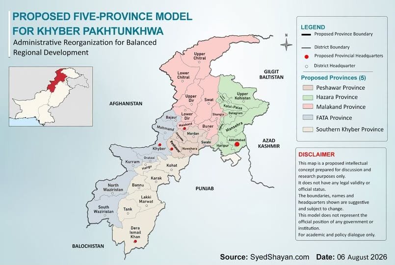
How Many Provinces Should Khyber Pakhtunkhwa Be Divided Into? 🔳 Subject: Does Pakistan Really Need New Provinces? | Episode 4 Title: How Many Provinces Should Khyber Pakhtunkhwa Be Divided Into? 🔺 Differences of opinion on national issues are natural, but serious debate and national consensus are essential for finding sustainable solutions. Written and Researched by Syed Shayan Khyber Pakhtunkhwa, formerly known as the North West Frontier Province and historically associated with the regions of Gandhara and Afghania, acquired its present geographical form primarily on 31 May 2018, when the former FATA was merged into Khyber Pakhtunkhwa through the 25th Constitutional Amendment. Before that, FATA was not part of Khyber Pakhtunkhwa. It was a separate territory administered by the federation. The name of the province itself was changed from the North West Frontier Province to Khyber Pakhtunkhwa in 2010 through the 18th Constitutional Amendment. On the basis of the preliminary analysis conducted by our think tank, a model of 5 provinces for Khyber Pakhtunkhwa appears more workable in terms of population, geography, economic capacity and administrative balance. The proposed structure is as follows. 🔘 Province of Peshawar ▫️ Districts: Peshawar, Nowshera, Charsadda, Mardan, Swabi ▫️ Population 2023: 12,974,469 ▫️ Total Area: 7,437 square kilometres The main reason for proposing Peshawar as a separate province is that Peshawar, Nowshera, Charsadda, Mardan and Swabi are located within the same geographical region and are connected through a strong road and transport network. Peshawar, Charsadda and Nowshera have historically formed part of the urban, agricultural and commercial system of the Peshawar Valley, while Mardan and Swabi are also closely linked with the economy and everyday life of the same region. The proposed province would not be very large in area, but it would have a substantial population and would hold particular importance within Khyber Pakhtunkhwa in terms of education, healthcare, industry, trade, agriculture and public services. Peshawar is the largest centre for education, healthcare, employment, business and government administration. Nowshera is important for industry, defence installations and agriculture. Charsadda has a strong agricultural and food related economy, while Mardan and Swabi hold important positions in education, industry and agricultural production. If these areas were combined into a separate province, the administrative burden on the present Khyber Pakhtunkhwa government could be reduced and decisions could be made more rapidly and more effectively according to the specific needs of this region. 🔘 Province of Hazara ▫️ Districts: Abbottabad, Haripur, Mansehra, Battagram, Torghar, Kolai Palas, Upper Kohistan, Lower Kohistan ▫️ Population 2023: 6,188,736 ▫️ Total Area: 17,064 square kilometres The demand for a separate Hazara province is not new. It has remained part of the region’s politics and public debate for several decades. People in the region have long argued that Hazara possesses its own historical, geographical and regional identity and should therefore be granted provincial status. Hazara already exists as a complete administrative division. If it were made a province, the existing administrative structure could be expanded and used on a broader scale. Because of the distance from Peshawar and the mountainous terrain, access to the provincial capital is particularly difficult for people living in Kohistan, Torghar and Battagram. Hazara also has a strong economic base. Tourist destinations such as Naran, Kaghan, Shogran, Balakot and the Galiyat, together with Tarbela Dam, other hydropower projects, mineral resources, forests and the northern route of CPEC, constitute major economic strengths of the region. If Abbottabad were made the provincial capital, public services, basic facilities and development resources could be delivered more effectively to remote and difficult mountainous areas. 🔘 Province of Malakand ▫️ Districts: Swat, Buner, Shangla, Upper Dir, Lower Dir, Malakand, Upper Chitral, Lower Chitral ▫️ Population 2023: 8,671,439 ▫️ Total Area: 29,872 square kilometres There is currently no strong and organised political movement demanding a separate Malakand province, but the region possesses historical, geographical and administrative characteristics that provide a strong basis for considering such a proposal. The former states of Swat, Dir and Chitral were historically connected through the wider administrative structure of Malakand, while today Swat, Dir, Chitral, Buner, Shangla and Malakand together form a distinct mountainous region. Because of difficult terrain and long distances, travelling to Peshawar is particularly difficult and time consuming for residents of Chitral and Upper Dir. Much of the population lives in mountain valleys where requirements relating to roads, water, healthcare, education and public services differ substantially from those of the plains. Tourism, hydropower, forests, fruit orchards, minerals, emeralds and other precious stones represent important economic strengths of the region. The Kalash valleys of Chitral also provide the region with a distinctive cultural and tourism identity. If Malakand were established as a separate province, residents of remote mountain districts could gain better access to courts, hospitals, educational institutions and government offices, while decisions could be made in accordance with the region’s own requirements. 🔘 Province of FATA ▫️ Districts: Bajaur, Mohmand, Khyber, Orakzai, Kurram, North Waziristan, South Waziristan ▫️ Population 2023: 5,743,162 ▫️ Total Area: 22,407 square kilometres The demand for FATA to become a separate province has appeared in the past, although there was never complete political consensus within the tribal areas. A significant section of opinion supported merger with Khyber Pakhtunkhwa, while some political leaders and local groups favoured the creation of a separate province on the basis of FATA’s historical and geographical identity. For a long period, this region was governed under a constitutional, legal and administrative framework different from the rest of Pakistan. In 2018, it was merged into Khyber Pakhtunkhwa through the 25th Constitutional Amendment, but the border, social, security and development requirements of the tribal districts stretching from Bajaur to South Waziristan remain different from those of much of the rest of the province. This region forms one of Pakistan’s most important border belts with Afghanistan and for decades constituted the former Federally Administered Tribal Areas. Torkham and other border crossings are of fundamental importance for trade with Afghanistan and Central Asia. Although customs revenues are collected by the federation, the regional economy could be strengthened through the development of trade, transport, warehousing, markets, industry, minerals, tourism and local services. If a separate provincial government were established, the tribal districts could receive a clearer and more direct share in federal fiscal transfers, the provincial budget, development programmes and political representation. Decisions concerning border security, roads and other infrastructure, education, healthcare, employment and the rehabilitation of conflict affected areas could also be made more closely according to local needs. The principal advantage of creating a separate province could be that the region receives focused attention and that decisions are made locally. If the federation provides the necessary financial assistance and development investment during the initial years, the province could gradually become more financially sustainable through border trade, minerals, tourism and the local economy. A strong and developed border province would not only benefit the people of the region but could also serve as an important economic and security buffer for Pakistan along the Afghan border. 🔘 Province of Bannu or Southern Khyber ▫️ Districts: Kohat, Hangu, Karak, Bannu, Lakki Marwat, Tank, Dera Ismail Khan ▫️ Population 2023: 7,278,291 ▫️ Total Area: 24,961 square kilometres The principal reason for proposing Bannu or Southern Khyber as a separate province is that the needs of this region differ considerably from those of Peshawar and the northern districts. Kohat, Hangu, Karak, Bannu, Lakki Marwat, Tank and Dera Ismail Khan are geographically connected and already share commercial, economic and social linkages. Because of their distance from Peshawar, reaching the provincial capital can be difficult and time consuming for residents of these districts. Karak and Kohat are important for oil, gas, mineral resources and industry, while Bannu, Lakki Marwat, Tank and Dera Ismail Khan are major centres of agriculture, livestock, fruit and grain production. Dera Ismail Khan is located on the western route of CPEC and can also develop into an important commercial centre connecting Punjab, Balochistan, Khyber Pakhtunkhwa and the tribal districts. If this region were established as a separate province, greater attention could be given to local resources, oil and gas, agriculture, industry and development projects, while citizens could gain better access to government offices, courts, hospitals and educational institutions. (To be continued in the next instalment)
تمام تحریریں دیکھیں