
From Real Estate History
4 December
4 December 2002
Major deviations uncovered in Islamabad’s master plan, federal government orders full review in 2002
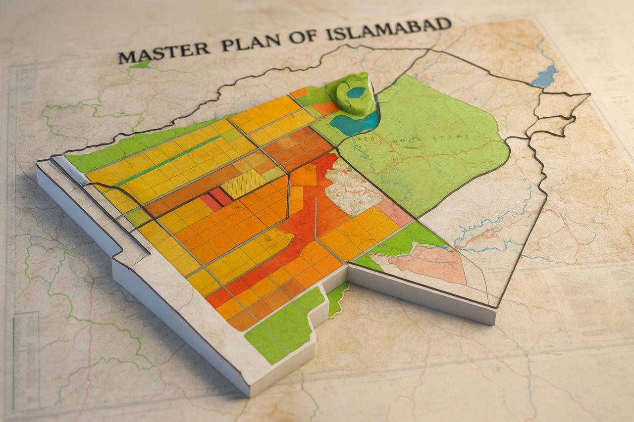
On 4 December 2002, the federal government approved the first comprehensive technical review of Islamabad’s 1960 master plan. The cabinet was informed that rapid population growth, uncontrolled commercialisation and extensive public and private construction had fundamentally altered the original plan, while land-use patterns and designated green areas had also changed significantly. The meeting emphasised the need to restore the master plan, protect green zones and enforce zoning regulations, directing the CDA to begin the technical review with the support of international specialists.
Below are the verified deviations and alterations recorded in the 1960 master plan of Islamabad.
▫️Over 40 percent of land use had changed
The original distribution of land residential, commercial, institutional and green areas, had been altered by more than 40 percent, either officially changed or used in an unplanned manner.
▫️Nearly 30 percent reduction in green areas
Green belts, parks and reserved forests were reduced by almost one third compared to the original plan. Public and private construction, expansion of institutional buildings, residential encroachments and illegal occupation severely damaged the city’s green cover.
▫️Commercial zones had tripled
Islamabad was originally designed as a non commercial capital, but by 2002, uncontrolled commercialisation had expanded markets, plazas, marriage halls and private businesses to nearly three times the size of the original commercial zones.
▫️Over 100 zoning violations recorded
According to CDA’s internal reports, more than 100 documented violations were identified across Zones I to V by 2002.
Examples included:
* Commercial construction on residential plots
* Encroachments in Zone 3 (foothills of Margalla)
* Institutional buildings on green areas
* Housing schemes in Zone 4 where only farming was permitted
▫️Alignment of 52 major roads and corridors changed
Increased traffic pressure had altered the original alignment at 52 locations, including redesigned intersections, re-engineered corridors, conversions from single to dual roads and overloaded urban arteries.
▫️Population exceeded projections by 250 percent
The 1960 master plan projected Islamabad’s population to remain between 300,000 and 400,000 by the year 2000.
But by 2002, the population had crossed one million, two and a half times higher than anticipated, placing enormous pressure on services, infrastructure and the environment.
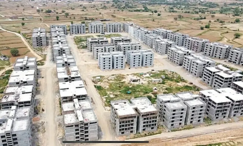
▫️Housing schemes expanded by 70 percent beyond planned limits
The spread of public and private housing schemes in Zones 2, 4 and 5 exceeded the master plan’s projections by 70 percent, much of it unplanned.
Summary
By 2002, Islamabad’s 1960 master plan had undergone severe distortion:
* 40 percent of land use had changed
* 25–30 percent of green areas were lost or damaged
* Commercial zones had expanded threefold
* More than 100 zoning violations had been recorded
* Alignment of 52 major roads had shifted
* Population exceeded projections by 250 percent
* Housing schemes had spread 70 percent beyond the planned limits
These factors prompted the federal government’s decision on 4 December 2002 to launch the first full technical review of the master plan. The aim was to reorganise the capital’s development according to modern international planning standards.
Islamabad’s master plan, prepared in 1960 by Greek architect Constantinos A. Doxiadis, envisioned a capital defined by controlled population, extensive green belts, balanced sectoral architecture and environmental protection. However, weak enforcement over the decades gradually changed the city’s urban form.
By the 1980s, the city’s population began increasing at a pace never anticipated by the master plan. The projected three to four lakh residents grew to over one million by 2002, placing direct pressure on public services, roads, parks, traffic systems and the environment.
▪References:
4 دسمبر 2002
اسلام آباد شہر کے ماسٹر پلان میں سنگین انحرافات ، وفاق نے 2002 میں مکمل جائزے کا حکم دیا
4 دسمبر 2002 کو وفاقی حکومت نے اسلام آباد کے 1960 ماسٹر پلان کے پہلے جامع تکنیکی ریویو کی منظوری دی۔ کابینہ کو بتایا گیا کہ آبادی کے تیز اضافے، بے قابو کمرشلائزیشن اور سرکاری و نجی تعمیرات نے ماسٹر پلان کو بنیادی طور پر متاثر کیا ہے، جبکہ اصل لینڈ یوز اور گرین ایریاز بھی نمایاں حد تک تبدیل ہو چکے ہیں۔ اجلاس میں ماسٹر پلان کی بحالی، گرین زونز کے تحفظ اور زوننگ قوانین کے مؤثر نفاذ کے لیے جامع ری انجینئرنگ اسٹڈی کی ضرورت پر زور دیا گیا اور سی ڈی اے کو بین الاقوامی ماہرین کی مدد سے تکنیکی ریویو شروع کرنے کی ہدایت دی گئی۔
اسلام آباد کے 1960 ماسٹر پلان میں جو مصدقہ تبدیلیاں اور انحرافات ریکارڈ پر آئے، ان کا خلاصہ ذیل میں پیش ہے۔
▫️چالیس فیصد سے زیادہ لینڈ یوز تبدیل ہو چکا تھا
اصل ماسٹر پلان میں زمین کی جو تقسیم تھی (رہائشی، کمرشل، ادارہ جاتی اور گرین ایریاز)، اس کا چالیس فیصد سے زائد حصہ تبدیل ہو گیا تھا یا اس کا استعمال تبدیل شدہ شکل میں آ چکا تھا۔
▫️گرین ایریاز کا تقریباً تیس فیصد حصہ متاثر ہوا
گرین بیلٹس، پارکس اور جنگلات کے لیے مخصوص علاقہ اصل ماسٹر پلان کی نسبت تقریباً ایک تہائی کم ہو گیا تھا۔ متعدد مقامات پر سرکاری و نجی تعمیرات، اداروں کی عمارتیں، رہائشی توسیع اور تجاوزات کے باعث گرین کور شدید متاثر ہوا۔
▫️کمرشل زون تین گنا بڑھ گئے تھے
اسلام آباد کو بنیادی طور پر ایک غیر تجارتی (Non Commercial) دارالحکومت کے طور پر ڈیزائن کیا گیا تھا، لیکن 2002 تک بے قابو کمرشلائزیشن کے نتیجے میں مارکیٹس، پلازے، میرج ہالز اور دیگر کمرشل سرگرمیاں اصل کمرشل زونز کے مقابلے میں تقریباً تین گنا بڑھ چکی تھیں۔
▫️زوننگ ریگولیشنز کی سو سے زائد خلاف ورزیاں ریکارڈ ہوئیں
CDA کی اندرونی رپورٹس کے مطابق 2002 تک زون I تا زون V میں ایک سو سے زیادہ documented خلاف ورزیاں سامنے آئیں۔
مثلاً:
* رہائشی پلاٹس پر کمرشل تعمیر
* زون 3 (مارگلہ کی پہاڑیوں کے دامن) میں تجاوزات
* گرین ایریاز پر ادارہ جاتی عمارتیں
* زون 4 میں فارمنگ کی جگہ ہاؤسنگ اسکیمیں
▫️52 سڑکوں اور شاہراہوں کا اصل alignment تبدیل ہو گیا
ٹریفک بڑھنے کے بعد شہر کے اندر 52 ایسے مقامات تھے جہاں سڑکوں کی ری انجینئرنگ، چوراہوں کی تبدیلی، سنگل سے ڈبل روڈز، اور اوورلوڈڈ کوریڈورز نے شہر کو اصل پلان سے ہٹا دیا۔
▫️آبادی 250 فیصد زیادہ ہو گئی تھی
1960 ماسٹر پلان میں اسلام آباد کی 2000 تک متوقع آبادی تین سے چار لاکھ رکھی گئی تھی، لیکن 2002 تک یہ آبادی دس لاکھ سے تجاوز کر گئی، جو کہ اصل پلان سے تقریباً ڈھائی گنا زیادہ ہے۔
▫️ہاؤسنگ اسکیمیں 70 فیصد اضافی پھیل گئیں
نجی اور سرکاری رہائشی اسکیموں کا پھیلاؤ زون 2، زون 4 اور زون 5 میں اصل ماسٹر پلان سے ستر فیصد زیادہ بڑھ گیا تھا، اور یہ توسیع زیادہ تر غیر منصوبہ بند تھی۔
▪️خلاصہ
2002 تک اسلام آباد کے 1960 ماسٹر پلان میں شدید بگاڑ پیدا ہو چکا تھا۔
* 40 فیصد لینڈ یوز تبدیل ہو چکا تھا
* 25 سے 30 فیصد گرین ایریاز ختم یا متاثر ہو گئے
* کمرشل زون تین گنا بڑھ گئے
* سو سے زیادہ زوننگ خلاف ورزیاں سامنے آئیں
* 52 سڑکوں کا alignment بدل چکا تھا
* آبادی اصل اندازے سے 250 فیصد زیادہ ہو گئی
* اور ہاؤسنگ اسکیمیں 70 فیصد اضافی علاقے تک پھیل گئیں
یہ تمام عوامل 4 دسمبر 2002 کے سرکاری فیصلے کا محرک بنے، جس کے تحت اسلام آباد کے ماسٹر پلان کا پہلا جامع تکنیکی ریویو شروع ہوا۔ اس اقدام کا مقصد دارالحکومت کی ترقی کو جدید بین الاقوامی اصولوں کے مطابق دوبارہ منظم کرنا تھا۔
یاد رہے کہ اسلام آباد کا ماسٹر پلان، جو 1960 میں یونانی ماہرِ تعمیرات کنسٹنٹائن ڈاکسیایڈس Constantinos A. Doxiadis نے تیار کیا تھا، ایک ایسے دارالحکومت کے طور پر تصور کیا گیا تھا جو محدود آبادی، وسیع گرین ایریاز، متوازن سیکٹرل آرکیٹیکچر اور ماحولیاتی تحفظ کے اصولوں پر قائم ہو۔ مگر وقت گزرنے کے ساتھ اس پلان پر عمل درآمد میں واضح کمزوریاں پیدا ہوئیں، جنہوں نے شہر کی شہری ساخت کو بتدریج تبدیل کر دیا۔
1980 کی دہائی میں دارالحکومت کی آبادی اس رفتار سے بڑھنے لگی جسے ماسٹر پلان نے کبھی تصور نہیں کیا تھا۔ متوقع تین سے چار لاکھ کی آبادی 2002 تک دس لاکھ سے زائد ہو چکی تھی، جس نے پبلک سروسز، سڑکوں، پارکوں، ٹریفک سسٹم اور ماحولیات پر براہ راست دباؤ ڈالا
(سید شایان رئیل اسٹیٹ آرکائیو: سیکشن پاکستان)
▪️سید شایان ریئل اسٹیٹ آرکائیو


No comments yet. Be the first to comment!