
From Real Estate History
26 November
26 November 1947
Punjab Issues Final Evacuee Property Survey Lists
On 26 November 1947 the Government of West Punjab completed its first major survey of Evacuee Property, documenting thousands of abandoned agricultural lands urban buildings and industrial units left behind during the mass migration of Partition. The survey established the first verified list of transferable assets that could be allocated to incoming Muslim refugees from East Punjab and northern India.
Municipal teams recorded street widths drainage paths property boundaries and ownership claims across almost fifteen thousand villages and towns. These verified lists became the basis for temporary and later permanent allotments to displaced families. The effort formed a critical administrative link between the chaos of migration and the creation of a new urban and rural ownership structure in Pakistan.
▪References:
•️ Impact on Real Estate Sector
The 1947 survey stabilised the disrupted land market by creating verified ownership records. It allowed structured redistribution of urban and agricultural properties and reduced violent disputes over abandoned assets.
•️ Policy Response
West Punjab introduced administrative procedures for boundary verification and claim registration. The Custodian of Evacuee Property supervised documentation and temporary allotments, building the foundation for later rehabilitation laws.
•️ Historical Legacy
The survey shaped the long term land governance system of Pakistan. Its methods informed later legislation including the Pakistan Administration of Evacuee Property Act 1957 and the Displaced Persons Compensation and Rehabilitation Act 1958.
•️ Current Status
Evacuee records from the 1947 survey remain part of the archival reference system used in property verification. Many urban neighbourhoods in Lahore Faisalabad and Rawalpindi still trace their ownership patterns to this early documentation.
26 نومبر 1947
تقسیم کے بعد جائیدادوں کی باقاعدہ منتقلی کا تاریخی آغاز
تقسیم ہند کے بعد لاکھوں افراد کی ہجرت کے نتیجے میں چھوڑی گئی جائیدادوں کے انتظام کا سنگین بحران پیدا ہوا تھا۔ مغربی پنجاب میں اس مسئلے سے نمٹنے کے لیے 26 نومبر 1947 کو ایوکیوئی پراپرٹی کے پہلے بڑے سروے کی بنیاد پر قابلِ انتقال املاک کی فائنل لسٹ جاری کی گئی، جس نے مہاجرین کی آبادکاری اور شہری و دیہی زمینوں کی نئی ملکیت کے ڈھانچے کو متعین کیا۔
ابتدائی اقدامات کے تحت 29 اگست 1947 کو “کیسٹوڈین آف ریفیوجیز پراپرٹی” کا نظام قائم کیا گیا تھا، جس کے بعد 23 ستمبر 1947 کو ویسٹ پنجاب حکومت نے Administration of Evacuee Property Act نافذ کیا۔ اس قانون کا مقصد ایوکیوئی جائیدادوں کی حفاظت، ان کی فہرست سازی اور فوری الاٹمنٹ کے انتظامات تھے۔
▪️سید شایان ریئل اسٹیٹ آرکائیو
•️ رئیل اسٹیٹ سیکٹر پر اثرات
26 نومبر 1947 کی فائنل لسٹ میں پنجاب کے تقریباً پندرہ ہزار دیہاتوں اور شہروں کے ریکارڈ شامل تھے۔ شہری علاقوں میں چھوڑی گئی ہندو اور سکھ جائیدادوں کی نشاندہی، زرعی اراضی کی حدبندی، صنعتی یونٹس کی تفصیل، اور قابلِ انتقال املاک کی نشریات اسی سروے کا حصہ تھیں۔ ریونیو افسران، پولیس اور کیسٹوڈین عملہ گھر گھر جا کر جائیدادوں کی تصدیق اور boundaries کی جانچ کرتا رہا۔
•️ پالیسی کا ردعمل
مغربی پنجاب نے سرحدوں کی تصدیق اور دعووں کی رجسٹریشن کے لیے انتظامی طریقۂ کار متعارف کرائے۔ متروکہ املاک کے متولی نے دستاویزات اور عارضی الاٹمنٹ کی نگرانی کی، جس نے بعد میں بحالی سے متعلق قوانین کی بنیاد رکھی
•️ تاریخی ورثہ
یہ عمل نہ صرف لوٹی گئی جائیدادوں کی واپسی میں اہم ثابت ہوا بلکہ مہاجرین کو عارضی اور بعد ازاں مستقل ملکیت دینے کے نظام کی بنیاد بھی بنا۔ بعد کے قوانین، خاص طور پر Displaced Persons Act 1958، اسی سروے کے نتائج پر ترتیب پائے۔ یہ سروے پاکستان کے بڑے شہروں لاہور، فیصل آباد، ملتان اور راولپنڈی کے نئے مالکانہ نظام کی تشکیل کا بنیادی مرحلہ تھا۔
•️ موجودہ حیثیت
1947 کے سروے سے حاصل شدہ مہاجر املاک کے ریکارڈ آج بھی جائیداد کی توثیق کے لیے استعمال ہونے والے آرکائیول ریفرنس سسٹم کا حصہ ہیں۔ لاہور، فیصل آباد اور راولپنڈی کے کئی شہری محلّے آج بھی اپنی ملکیتی تاریخ کا سراغ اسی ابتدائی دستاویزی نظام سے لگاتے ہیں۔
26 November 1960
CDA Approves First Sector Boundary Map of the New Federal Capital
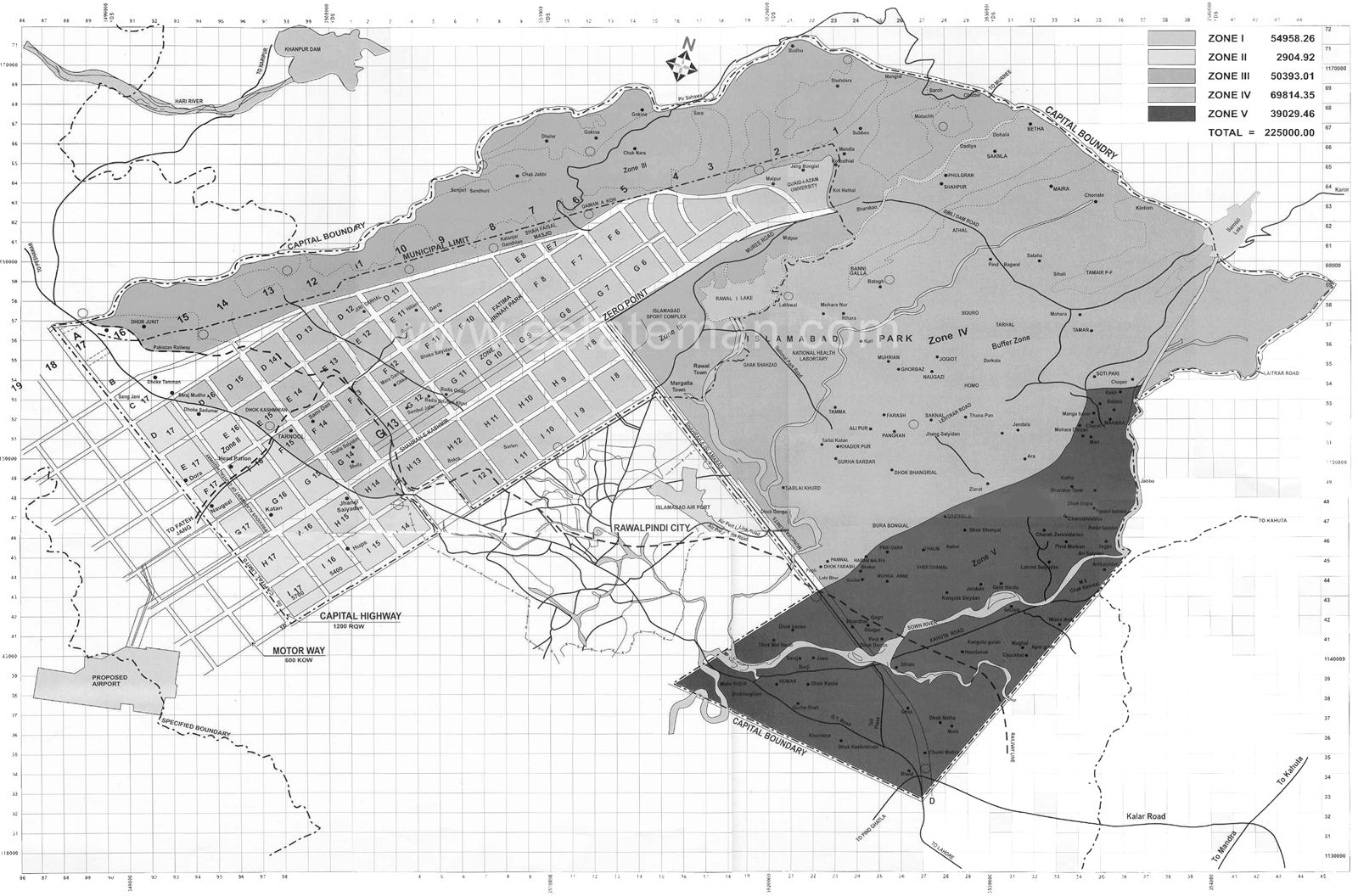
On this date, the Capital Development Authority formally approved the first sector boundary map for Pakistan’s newly designated federal capital, Islamabad. The authorisation marked one of the earliest and most consequential administrative steps taken by the newly formed authority, which had been established in June 1960 under the direction of President Muhammad Ayub Khan.
Prepared within the framework of the master plan developed by Doxiadis Associates of Athens, the boundary map confirmed the geometric layout of the F, G, H and I series sectors, forming the structural grid that would shape the capital’s long-term growth. The CDA chairman at the time, Major General Yahya Khan, described the approval as the foundational “planning DNA” of the new city.
Structure and Intent of the Sector Plan
Under the Doxiadis plan, Islamabad was conceived as a modern, orderly and environmentally integrated capital. The adopted boundary system arranged the city on a two by two kilometre grid, with each sector divided into four sub-sectors planned as self-contained communities. Residential, commercial, educational and recreational functions were placed within walkable distances, framed by green belts intended to protect natural landscapes.
F Series: Predominantly residential in nature, the F sectors were designed to house middle and lower-middle income groups, including federal employees. Early development was prioritised in F-6 and F-7, with planned parks, pedestrian routes and green buffers.
G Series: The G sectors were positioned as central residential and community zones. G-6, the first to be developed, was designed to be completed by the end of 1960, with markets, schools, mosques and health facilities integrated into its layout.
I Series: The I sectors served the industrial and commercial functions of the new city. Areas from I-8 to I-17 were assigned for light industry, transport hubs and office clusters, forming the economic base of Islamabad.
H Series: Reserved for higher-income residences and institutional development, the H sectors were planned to accommodate universities, hospitals and cultural facilities, establishing Islamabad as an administrative and academic centre.
Planning Philosophy and Long Term Significance
The approval reflected the Doxiadis concept of a “Dynapolis”, a city designed to expand gradually from the north-east to the south-west, preserving existing villages while creating space for controlled urban growth. Road hierarchies were calibrated at 100-foot dual carriageways, 80-foot single lanes and dedicated pedestrian pathways, ensuring orderly circulation and low environmental impact.
President Ayub Khan, while reviewing the approved boundaries, remarked that Islamabad was intended not only as the administrative heart of Pakistan but also as “a model Asian city”, combining human needs, natural setting and modern technology.
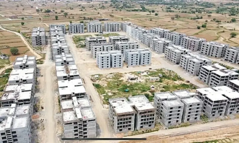
The 26 November approval laid the administrative and spatial foundations for all future development. It enabled the CDA to begin land acquisition, allocate resources and initiate phased construction. Work on F-6 and G-6 was scheduled for commencement in early 1961, with core infrastructure projected for completion by 1963.
Historical Context
The decision to relocate the capital from Karachi to a new site near Rawalpindi was taken in 1959 following a national review of administrative needs, geography and security. Doxiadis Associates submitted the first draft of the master plan in May 1960, and the boundary approval of November 1960 represented the earliest formal adoption of that plan.
Legacy
This boundary authorisation became the cornerstone of Islamabad’s urban identity. The grid it introduced remains intact to this day, guiding municipal planning, land regulation and infrastructure development. It is widely regarded as one of the most influential planning decisions in Pakistan’s urban history.
▪References:
26 نومبر 1960
سی ڈی اے نے شہر کے پہلے سیکٹر باؤنڈری میپ کی منظوری دے دی
کیپیٹل ڈویلپمنٹ اتھارٹی نے آج پاکستان کے نئے منصوبہ بند دارالحکومت اسلام آباد کے پہلے سرکاری سیکٹر باؤنڈری میپ کی باضابطہ منظوری دے دی ہے۔ یہ منظوری ایف (F)، جی (G)، آئی (I) اور ایچ (H) سیریز کے سیکٹروں کے لیے دی گئی ہے، جو شہر کے ماسٹر پلان کی بنیادی اکائیوں میں شمار ہوں گے۔ سی ڈی اے کے چیئرمین میجر جنرل یحییٰ خان نے اس منظوری کو “شہر کی مستقبل کی ترقی کا بنیادی نقشہ” قرار دیا ہے۔
یہ فیصلہ سی ڈی اے کی تشکیل کے چند ماہ بعد سامنے آیا ہے۔ اتھارٹی جون 1960 میں صدر ایوب خان کے حکم پر قائم کی گئی تھی، جسے اسلام آباد کی تعمیر، اراضی کے حصول، ترقیاتی کاموں اور ضابطوں کی نگرانی کی ذمہ داری دی گئی۔ یونانی ماہر شہر ساز کمپنی ڈوکسیاڈیس ایسوسی ایٹس کی تیار کردہ ماسٹر پلان کے مطابق شہر کو گرڈ آئرن نظام میں تقسیم کیا گیا ہے، جہاں ہر سیکٹر تقریباً دو کلومیٹر ضرب دو کلومیٹر کے مربع پر مشتمل ہوگا اور چار سب سیکٹروں میں تقسیم ہوگا۔
سیکٹروں کی تفصیلات اور منصوبہ ▫بندی
ایف سیریز (F Series)▫
یہ سیکٹرز بنیادی طور پر رہائشی علاقوں کے لیے مختص ہیں۔ ایف 6 اور ایف 7 جیسے سیکٹرز میں سرکاری ملازمین کی رہائش کے ابتدائی انتظامات کیے جائیں گے۔ گرین بیلٹس، پارکس، پیدل راستے اور مقامی سہولیات ہر سیکٹر کا لازمی حصہ ہوں گے۔
جی سیریز (G Series)▫
جی 6 کو اسلام آباد کا پہلا مکمل رہائشی سیکٹر قرار دیا گیا ہے، جو 1960 کے آخر تک تیار ہونے کی امید ہے۔ یہاں مارکیٹس، سکولوں، مساجد اور ہسپتالوں کی تعمیر ماسٹر پلان کے مطابق کی جا رہی ہے۔ جی سیریز شہر کے مرکزی حصے میں واقع ہے اور انتظامی دفاتر سے قریب ہے۔
آئی سیریز (I Series)▫
یہ سیکٹرز صنعتی، کمرشل اور ٹرانسپورٹ سرگرمیوں کے لیے مخصوص کیے گئے ہیں۔ آئی 8 سے آئی 17 تک کے علاقوں میں چھوٹی صنعتیں، کاروباری دفاتر، اور ٹرانسپورٹ ہبس قائم کیے جائیں گے۔ یہ اسلام آباد کی اقتصادی سرگرمیوں کا مرکز ہوں گے۔
ایچ سیریز (H Series)▫
ایچ 8 سے ایچ 17 تک کے سیکٹرز اعلیٰ تعلیم، ہسپتالوں اور جدید رہائش کے لیے مختص ہیں۔ یہاں یونیورسٹیاں، تحقیقاتی ادارے اور تفریحی مراکز شامل ہوں گے۔ سی ڈی اے کے مطابق ایچ سیریز اسلام آباد کو ایک علمی و صحت کے مرکز میں تبدیل کرے گی۔
شہر کی منصوبہ بندی کا ڈھانچہ▫
سی ڈی اے کے مطابق باؤنڈری میپ کی منظوری سے شہر کی یکساں اور سائنسی بنیادوں پر ترقی ممکن ہو سکے گی۔ ماسٹر پلان میں “ڈائناپولیس” (Dynapolis) کا تصور شامل ہے، جس کے تحت شہر شمال مشرق سے جنوب مغرب تک منظم توسیع کے قابل ہوگا۔ ہر سیکٹر کے گرد گرین بیلٹس آلودگی اور شور سے تحفظ فراہم کریں گی۔
شہر کے روڈ نیٹ ورک کو درج ذیل درجہ بندی کے مطابق ترتیب دیا گیا ہے:
– سو فٹ چوڑی ڈبل روڈز
– اسی فٹ چوڑی سنگل روڈز
– پیدل سفر کے لیے علیحدہ راستے
تاریخی پس منظر اور اہمیت▫
1959 میں کراچی کے بجائے نیا دارالحکومت تعمیر کرنے کا فیصلہ کیا گیا۔ راولپنڈی کے قریب موجود خطہ ماہرین کے مطابق موسمی، جغرافیائی اور دفاعی طور پر موزوں تھا۔ ڈوکسیاڈیس ایسوسی ایٹس نے مئی 1960 میں ابتدائی ماسٹر پلان پیش کیا، جس کے فوراً بعد سی ڈی اے قائم کی گئی۔
صدر ایوب خان کے مطابق “اسلام آباد نہ صرف پاکستان بلکہ خطے کا ایک ماڈل شہر ہوگا، جہاں جدید ترقی، قدرتی ماحول اور شہری ضرورتوں کا توازن قائم ہوگا۔”
ماہرین کا کہنا ہے کہ سیکٹر باؤنڈری میپ کی منظوری اسلام آباد کی طویل المدتی شہری شناخت کا پہلا بنیادی قدم ہے۔
چیلنجز اور مستقبل کے منصوبے▫
سی ڈی اے کے مطابق تعمیرات کے آغاز میں اراضی کے حصول، فنڈنگ اور مشینری کی فراہمی کے چیلنجز موجود ہیں، لیکن حکومتی حمایت کے بعد منصوبہ تیزی سے مکمل ہوگا۔ پہلے مرحلے میں ایف 6 اور جی 6 پر ترقیاتی کام شروع کیے جائیں گے اور 1963 تک بنیادی تعمیر مکمل کرنے کا ہدف رکھا گیا ہے۔
شہریوں سے اپیل کی گئی ہے کہ وہ منصوبہ بندی کے اصولوں کے مطابق تعاون کریں تاکہ اسلام آباد کو دنیا کے بہترین دارالحکومتوں میں شامل کیا جا سکے۔
▪️سید شایان ریئل اسٹیٹ آرکائیو


No comments yet. Be the first to comment!