From Real Estate History
30 December
Real Estate Regulation, Law

Foundation Stone of Pakistan Steel Mills
On 30 December 1973, a day of exceptional significance in the industrial and urban history of Pakistan, former Prime Minister Zulfikar Ali Bhutto laid the foundation stone of Pakistan Steel Mills at Bin Qasim, Steel Town, to the east of Karachi, beyond the then urban limits of the city. This project not only became a symbol of Pakistan’s industrial sovereignty but also led to an immediate and notable rise in land values across the surrounding areas of Karachi. Pakistan Steel Mills was established on approximately eighteen thousand six hundred acres of land near Karachi. Spread across such an extensive area, it was not merely an industrial unit but effectively a city within a city. The scale of this development can be understood by comparing it to Sukkur, the third largest city of Sindh, whose present urban area is approximately seventy five square kilometres. The land occupied by Pakistan Steel Mills was comparable to, and in some assessments larger than, the urban footprint of Sukkur. This vast expanse comprised the main industrial complex of the steel mills, the residential settlement of Steel Town, supporting infrastructure, roads, railway connections, and essential utilities. From a research perspective, it would not be inaccurate to describe Pakistan Steel Mills as one of the most prominent examples of large scale industrial land use undertaken by the state at that time. Its impact extended beyond industrial production to influence national patterns of urban expansion and land utilisation. As a result of this project, extensive coastal and semi agricultural land near Karachi was converted to industrial use. Over thousands of acres, the central steel complex, residential colonies, roads, utilities, and auxiliary infrastructure were developed, giving rise to a fully integrated industrial and urban zone in the Bin Qasim area. In parallel, Steel Town emerged as a planned residential city, designed specifically to accommodate industrial workers and government employees. From the perspective of real estate and urban development, the establishment of Pakistan Steel Mills triggered an extraordinary expansion of Karachi’s urban boundaries. Coastal and underdeveloped land underwent a fundamental transformation, land values increased significantly, and a new urban model emerged based on the interrelationship between port activity, industry, and residential settlement. This project became a defining example of large scale industrial land use by the state in Pakistan. From an archival standpoint, 30 December 1973 stands as the date that permanently reshaped the geographical, urban, and property landscape of Karachi’s eastern coastline. It is preserved as a milestone in the history of industrial real estate development in Pakistan.
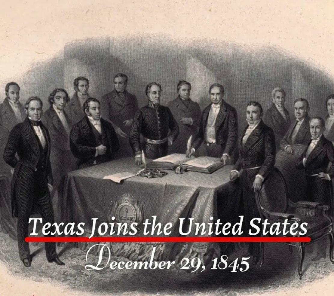
The Annexation of Texas to the United States
On 29 December 1845, Texas formally became the twenty eighth state of the United States. This event was not merely a political decision. It marked an extraordinary turning point in the global history of land ownership and real estate. As a result of this single day’s decision, approximately 259000 square miles, or nearly 695000 square kilometres, came under the jurisdiction of the American federal system. Texas held a unique position because it had previously existed as an independent republic. The land was already settled. Agriculture was actively practised. Claims of private as well as communal ownership were firmly in place. When Texas was annexed by the United States, all these lands were brought under the American constitutional and legal framework in a single moment. This transition reshaped land registration, land claims, agricultural ownership, and future urban planning within an entirely new framework influenced by American legal culture. Concepts of ownership, legal documentation, boundary demarcation, and patterns of urban expansion shifted from local traditions to align with the federal American system. The historical importance of this annexation is further underscored by the fact that it represented the largest territorial addition ever gained through the admission of a sovereign state into the United States. At the time, the area exceeded that of several European countries and opened the path for the expansion of the American property market towards the southern and western regions. In subsequent decades, these lands formed the foundation for vast agricultural estates, railway networks, industrial centres, and newly established cities. One of the most significant outcomes of Texas’s annexation for the United States was the acquisition of an extensive coastline, providing strong and direct access to the Gulf of Mexico. This geographical transformation also produced a broader economic benefit for landlocked states. The development of ports along the Texas coast created new and more accessible routes for the agricultural and industrial output of inland regions to reach global markets. Over time, as expansive railway networks and integrated river systems connected these landlocked states to the Texas coastline, interior regions became part of the global trade system. In this way, the annexation of Texas emerged as a gradual yet profoundly significant milestone in the overall economic growth of the United States.
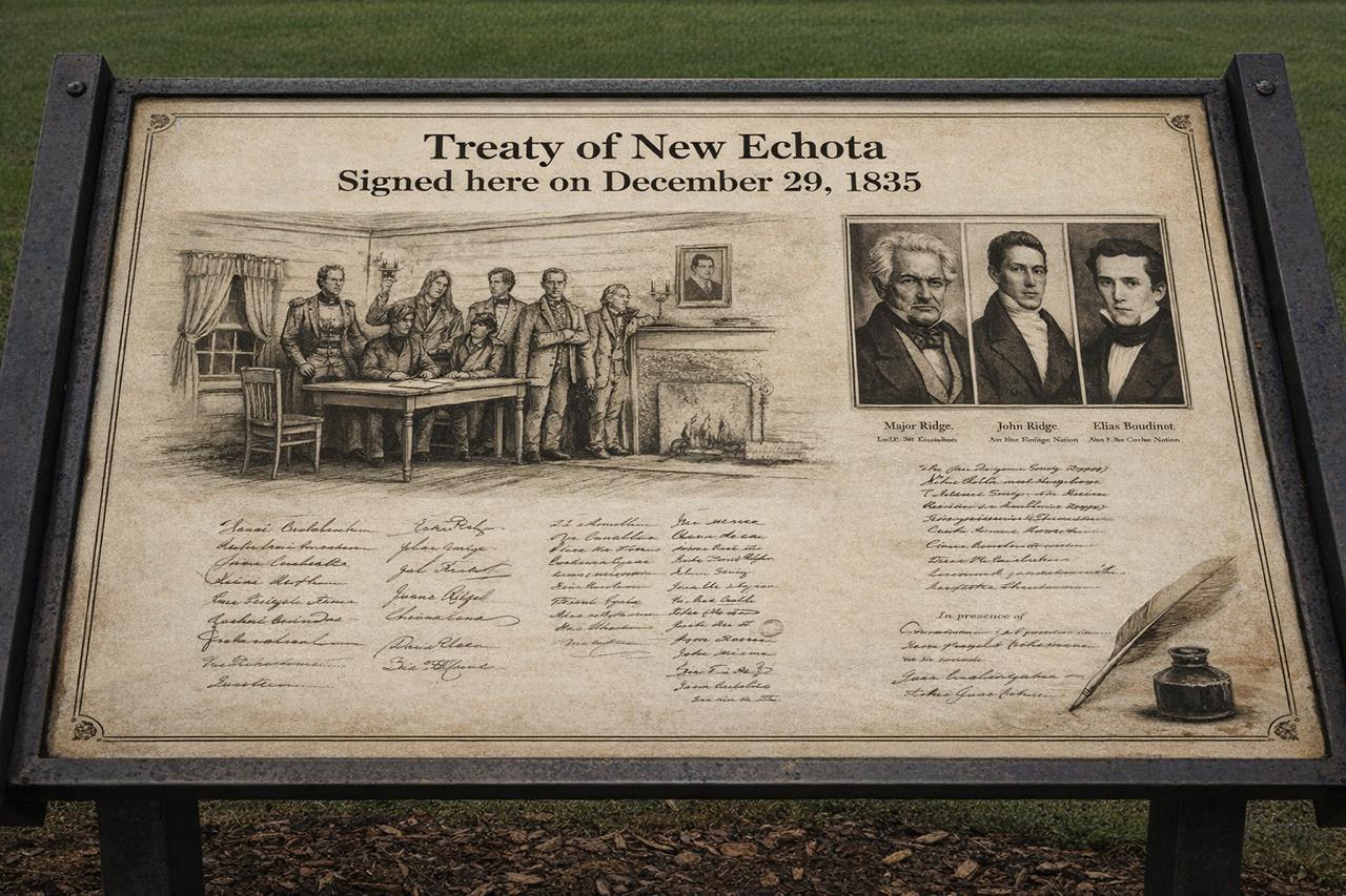
Treaty of New Echota When a minority group negotiated away an entire nation and its land
On 29 December 1835, a legal treaty was concluded in the American state of Georgia, historically known as the Treaty of New Echota. This agreement is regarded as one of the most controversial and troubling chapters in United States history, particularly in relation to land ownership, state authority, and the rights of Indigenous nations. By the early nineteenth century, the south eastern states of the United States, especially Georgia, Alabama, and Tennessee, had become centres of an expanding agricultural economy. Cotton cultivation, commonly referred to as the Cotton Economy, was growing rapidly, leading to an exceptional demand for fertile land. Large tracts of this land were owned by Indigenous communities, most notably the Cherokee Nation. Their continued presence was increasingly viewed as an obstacle to the American policy of westward territorial expansion. Within this context, the United States Congress passed the Indian Removal Act in 1830, which provided the legal framework for the forced relocation of Indigenous peoples from east of the Mississippi River to lands further west. The Treaty of New Echota emerged as a direct outcome of this policy. The treaty was finalised on 29 December 1835 at New Echota, which was then the capital of the Cherokee Nation. Under its terms, the Cherokee ceded all their lands east of the Mississippi River to the United States government. This territory amounted to approximately seven million acres. In return, the government promised compensation of five million dollars and the allocation of alternative land in the west. This land lay within the area of present day Oklahoma, known at the time as Indian Territory. From a legal perspective, the most contentious aspect of the treaty concerned the issue of representation. The agreement was not signed by the elected leadership or the national council of the Cherokee Nation. Instead, it was endorsed by a small political faction, later known as the Ridge Party, whose members included Major Ridge, John Ridge, Elias Boudinot, and Stand Watie. The principal chief of the Cherokee Nation, John Ross, along with the majority of the national council, rejected the treaty as invalid and contrary to the collective will of the people. The United States was represented in the negotiations by John F. Schermerhorn, a federal commissioner. Despite widespread opposition among the Cherokee population, the United States Senate ratified the treaty by a margin of just one vote. This ratification elevated the agreement to the status of federal law and paved the way for the use of state force. When a large proportion of the Cherokee people refused to comply with the treaty and abandon their ancestral lands, the United States military initiated a programme of forced removal. Between 1838 and 1839, thousands of Cherokee men, women, and children were gathered into detention camps and subsequently transported westwards. This episode became known in history as the Trail of Tears. Historical records indicate that approximately sixteen thousand Cherokee individuals were forcibly displaced from their homelands. The journey covered an average distance of twelve hundred miles and was undertaken on foot, by riverboats, and with limited means of transport. Severe weather conditions, inadequate food supplies, disease, and poor administration resulted in the deaths of an estimated four thousand people. In the Cherokee language, this journey is remembered as Nu na da ut sun y, meaning the place where they cried. After arriving in the west, the Cherokee Nation re established its political and social institutions in Oklahoma. Tahlequah was designated as the new capital, and systems of constitutional governance, courts, educational institutions, and newspapers were rebuilt. Nevertheless, their legal ownership of their former eastern lands was considered permanently extinguished. The legacy of this treaty has not entirely faded in the modern era. In 2020, the United States Supreme Court, in the case of McGirt v. Oklahoma, affirmed that large parts of Oklahoma legally remain tribal reservation land, as earlier treaties had never been formally revoked. This ruling carried significant implications for land rights, jurisdiction, and property law. [img:Images/2nd-image-29-dec.jpeg | desc:The Treaty of New Echota and the subsequent forced removal of the Cherokee people have been the subject of numerous serious documentary films and historical reconstructions based on official records and archival evidence. Notable among these are Trail of Tears: Cherokee Legacy and the PBS series We Shall Remain, which examine the legal and political consequences of the Indian Removal Act and the Treaty of New Echota. These works illustrate how treaties and federal policy were used to reshape patterns of land ownership and population geography. ] The Treaty of New Echota has been included in the Syed Shayan Real Estate Archives to serve as a reminder of how state policy, legal instruments, and economic interests can combine to dispossess ordinary people of their land.
The Florida Land Boom of the 1920s The Florida Land Boom is widely regarded as the first major speculative bubble of the modern real estate era, a period when land could change hands several times within a single day, each transaction multiplying its price
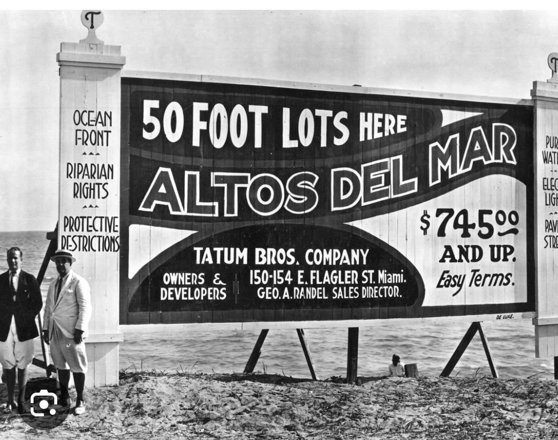
Exactly one century ago, on 23 December 1925, the most famous real estate phenomenon in American history stood at its absolute peak. Across Florida, particularly in Miami and Palm Beach, the purchase of land had transformed into a national obsession. The promise was simple and intoxicating: fortunes could be made overnight. At the height of the boom, even the smallest plots in virtually any district of these cities could double in value within hours. Buyers routinely paid advances without inspecting the land, and in many cases plots were resold for profit even before formal registration was completed. Real estate agents, investors, and ordinary citizens alike were swept into the frenzy, united by a shared conviction that prices would never fall. Contemporary newspaper reports from December 1925, most notably the 23 December edition of The Miami Herald, describe scenes bordering on the extraordinary. Despite the Christmas holidays, thousands queued to purchase land. Railway stations, ports, and land offices were overwhelmed, while civic systems struggled to cope with the sheer volume of speculative activity. Economic historians have since identified this episode as the first great real estate bubble of the modern age. Land values were no longer determined by housing needs or economic fundamentals, but by speculation, rumour, and the pursuit of rapid profit. The boom, however, proved unsustainable. In 1926, a devastating hurricane struck Florida, destroying vast areas and shattering investor confidence almost overnight. Economic strains quickly followed, land prices collapsed with remarkable speed, and the Florida Land Boom, once celebrated worldwide as a symbol of opportunity and prosperity, became a lasting cautionary tale in real estate history. When examined plainly, the underlying story is unmistakably clear. Following the First World War, the United States experienced a surge in wealth. Automobiles became commonplace, railways and advertising compressed distances, and Florida was marketed as a dreamland where sunshine, oceanfront living, and rapidly expanding cities promised universal prosperity. In Miami and Palm Beach in particular, land was no longer acquired for settlement but for immediate resale. Plots were purchased without inspection, without maps, and often without any understanding of location, driven solely by hearsay and expectations of rising prices. A plot acquired in the morning could pass through several owners by evening. Land ceased to function as an asset rooted in utility and instead became a certificate of anticipated wealth, sustained by the collective belief that prices could only rise. The fundamental weakness of the system lay in the absence of genuine end users. Most buyers had no intention of building homes or establishing communities. They were merely waiting for the next purchaser. Once the flow of new buyers slowed, the structure began to falter. By late 1925, rail networks were paralysed, not by building materials, but by the transport of land documents. Banks began to restrict lending, buyers disappeared, and for the first time prices stagnated. These were the early signs of collapse.[img:Images/2nd-image-23-dec1.jpeg | desc:This board is a striking example of the deceptive advertising that characterised the Florida Land Boom. Swamp land and waterlogged areas were promoted as “reclaimed land” and boldly described as “the richest soil in the world.” The purpose of such language was not to reflect the land’s actual condition, but to convince buyers that an immediate purchase would yield rapid profits. In reality, most of these plots were neither properly drained nor suitable for housing or cultivation. Yet slogans such as “buy now at ground floor prices” were used to intensify speculation. This form of misleading promotion played a central role in inflating the Florida Land Boom into a speculative bubble, which ultimately left thousands of investors facing heavy financial losses.] Two decisive developments in 1926 rendered the decline irreversible. First, a powerful hurricane struck Miami, destroying thousands of structures, crippling ports, and exposing the reality that the city had been sold far faster than it had been built, secured, or prepared. Second, confidence among banks and developers evaporated. As payments ceased and instalments defaulted, the very documents once regarded as wealth became liabilities. Countless individuals who had purchased land through borrowed funds lost everything. The outcome was severe. In many areas, land values fell by fifty to seventy percent. Thousands of projects were abandoned, banks failed, and Florida’s economy was set back for years. Crucially, all of this occurred three years before the Great Depression of 1929. For this reason, scholars consistently identify the Florida Land Boom as the first modern speculative real estate bubble, containing all the defining elements later repeated across the world: purchases driven by rumour, the absence of real demand, faith in effortless profit, and the sudden collapse of systemic confidence. The enduring lesson of the Florida Land Boom is unmistakable. Land was stripped of its function as shelter and long-term asset and transformed into a vehicle for rapid speculation. When buyers place their faith solely in the next buyer and abandon underlying use, prices may rise, but they cannot endure. This principle lies at the heart of why the episode is still taught in universities across the United States and beyond, within disciplines such as real estate studies, economics, urban planning, and finance. Students are shown how speculation, market psychology, and the abandonment of economic fundamentals combine to inflate bubbles, and how those same forces ultimately precipitate collapse. Estimates of the financial losses caused by the Florida Land Boom have varied across historical accounts, and no single official figure exists. Nevertheless, economic historians have established a broadly accepted consensus range. Historical records indicate that during the early 1920s, speculative land transactions in Florida reached an estimated total value of six to seven billion US dollars in 1920s terms. When the bubble collapsed between 1925 and 1926, direct and indirect losses are estimated at approximately two billion US dollars in contemporary values. This figure appears consistently in American economic history and is regarded as a confirmed historical estimate. Adjusted for inflation, these losses equate to approximately thirty to thirty-five billion US dollars in present-day terms. It is important to note that the damage extended far beyond declining land prices. It encompassed widespread bank failures, the cancellation of construction projects, loan defaults, and the prolonged paralysis of Florida’s state economy.


.jpeg)
.jpeg)
.jpg)


.jpg)